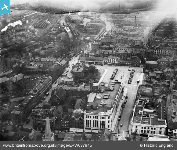
EPW037845 ENGLAND (1932). King's Square and environs, Gloucester, 1932
© Copyright OpenStreetMap contributors and licensed by the OpenStreetMap Foundation. 2025. Cartography is licensed as CC BY-SA.
Nearby Images (12)
Details
| Title | [EPW037845] King's Square and environs, Gloucester, 1932 |
| Reference | EPW037845 |
| Date | May-1932 |
| Link | |
| Place name | GLOUCESTER |
| Parish | |
| District | |
| Country | ENGLAND |
| Easting / Northing | 383372, 218578 |
| Longitude / Latitude | -2.2415103339089, 51.865092705999 |
| National Grid Reference | SO834186 |
Pins
 gBr |
Wednesday 17th of May 2023 08:32:54 PM | |
 Class31 |
Friday 5th of June 2015 11:44:46 AM | |
 galatea |
Saturday 7th of February 2015 03:33:11 PM | |
 marcus |
Sunday 5th of May 2013 09:37:41 PM | |
 marcus |
Sunday 5th of May 2013 09:37:20 PM | |
 marcus |
Sunday 5th of May 2013 09:36:42 PM |


![[EPW037845] King's Square and environs, Gloucester, 1932](http://britainfromabove.org.uk/sites/all/libraries/aerofilms-images/public/100x100/EPW/037/EPW037845.jpg)
![[EPW041488] Station Road, Russell Street and the city centre, Gloucester, 1933](http://britainfromabove.org.uk/sites/all/libraries/aerofilms-images/public/100x100/EPW/041/EPW041488.jpg)
![[EPW037846] The cattle market, King's Square and the city centre, Gloucester, 1932](http://britainfromabove.org.uk/sites/all/libraries/aerofilms-images/public/100x100/EPW/037/EPW037846.jpg)
![[EPW037844] The cattle market, St Aldate Street and the city centre, Gloucester, 1932](http://britainfromabove.org.uk/sites/all/libraries/aerofilms-images/public/100x100/EPW/037/EPW037844.jpg)
![[EPW001179] Gloucester Cathedral, Station and town centre, Gloucester, 1920](http://britainfromabove.org.uk/sites/all/libraries/aerofilms-images/public/100x100/EPW/001/EPW001179.jpg)
![[EPW006016] The city centre, Gloucester, 1921. This image has been produced from a copy-negative.](http://britainfromabove.org.uk/sites/all/libraries/aerofilms-images/public/100x100/EPW/006/EPW006016.jpg)
![[EAW018729] The city, Gloucester, 1948. This image has been produced from a print.](http://britainfromabove.org.uk/sites/all/libraries/aerofilms-images/public/100x100/EAW/018/EAW018729.jpg)
![[EAW000727] Holy Trinity Cathedral and the city, Gloucester, 1946](http://britainfromabove.org.uk/sites/all/libraries/aerofilms-images/public/100x100/EAW/000/EAW000727.jpg)
![[EAW032306] Holy Trinity Cathedral, Gloucester, 1950](http://britainfromabove.org.uk/sites/all/libraries/aerofilms-images/public/100x100/EAW/032/EAW032306.jpg)
![[EAW003568] Gloucester Cathedral, Gloucester, 1947](http://britainfromabove.org.uk/sites/all/libraries/aerofilms-images/public/100x100/EAW/003/EAW003568.jpg)
![[EAW003569] Gloucester Cathedral, Gloucester, 1947](http://britainfromabove.org.uk/sites/all/libraries/aerofilms-images/public/100x100/EAW/003/EAW003569.jpg)
![[EPW024170] Holy Trinity Cathedral and environs, Gloucester, 1928](http://britainfromabove.org.uk/sites/all/libraries/aerofilms-images/public/100x100/EPW/024/EPW024170.jpg)