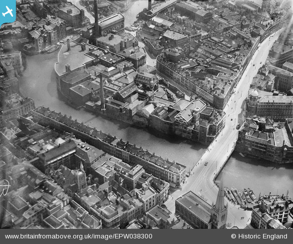
EPW038300 ENGLAND (1932). George's Brewery and Bristol Bridge, Bristol, 1932
© Copyright OpenStreetMap contributors and licensed by the OpenStreetMap Foundation. 2025. Cartography is licensed as CC BY-SA.
Nearby Images (27)
Details
| Title | [EPW038300] George's Brewery and Bristol Bridge, Bristol, 1932 |
| Reference | EPW038300 |
| Date | June-1932 |
| Link | |
| Place name | BRISTOL |
| Parish | |
| District | |
| Country | ENGLAND |
| Easting / Northing | 359078, 172934 |
| Longitude / Latitude | -2.5890046029914, 51.453418421511 |
| National Grid Reference | ST591729 |
Pins
 adfbristol |
Thursday 16th of April 2020 01:48:15 PM | |
 adfbristol |
Thursday 16th of April 2020 01:47:03 PM | |
 MB |
Sunday 20th of January 2013 11:07:40 PM | |
 MB |
Sunday 20th of January 2013 11:06:21 PM | |
 Class31 |
Sunday 20th of January 2013 11:05:52 PM | |
 Class31 |
Sunday 20th of January 2013 11:05:10 PM | |
Details of Bridge Street in 1937 here: www.flickr.com/photos/brizzlebornandbred/2056421543/in/photostream/ |
 MB |
Sunday 20th of January 2013 11:21:37 PM |
 Class31 |
Sunday 20th of January 2013 11:04:36 PM | |
 Class31 |
Sunday 20th of January 2013 10:54:42 PM | |
 Class31 |
Sunday 20th of January 2013 10:54:11 PM | |
 MB |
Sunday 20th of January 2013 06:01:45 PM | |
 MB |
Sunday 20th of January 2013 06:00:00 PM | |
 MB |
Sunday 20th of January 2013 05:59:43 PM | |
 MB |
Sunday 20th of January 2013 05:59:14 PM | |
I'm afraid not. The is St. Mary le Port Church. St. Peter's is further east of this location. |
 Class31 |
Sunday 20th of January 2013 11:02:39 PM |
 MB |
Sunday 20th of January 2013 05:58:54 PM | |
 MB |
Sunday 20th of January 2013 05:58:25 PM | |
 MB |
Sunday 20th of January 2013 05:58:07 PM |
User Comment Contributions
More on Mary-le-Port Street: www.flickr.com/photos/brizzlebornandbred/2056421861/ The tower of St Mary-le-Port survived the German bombing; I've incorrectly labelled the church St Peter's, which as Class 31 points out is further to the east |
 MB |
Sunday 20th of January 2013 11:17:13 PM |
The tramlines are clearly visible on Bristol Bridge; the sunlight reflecting off them |
 MB |
Sunday 20th of January 2013 11:02:43 PM |


![[EPW038300] George's Brewery and Bristol Bridge, Bristol, 1932](http://britainfromabove.org.uk/sites/all/libraries/aerofilms-images/public/100x100/EPW/038/EPW038300.jpg)
![[EPW038303] Industry around the Bristol Bridge, Bristol, 1932](http://britainfromabove.org.uk/sites/all/libraries/aerofilms-images/public/100x100/EPW/038/EPW038303.jpg)
![[EPW038304] Victoria Street, George's Brewey and the W.B. Harris Print Works, Bristol, 1932](http://britainfromabove.org.uk/sites/all/libraries/aerofilms-images/public/100x100/EPW/038/EPW038304.jpg)
![[EPW033498] Bristol Bridge and the city, Bristol, 1930](http://britainfromabove.org.uk/sites/all/libraries/aerofilms-images/public/100x100/EPW/033/EPW033498.jpg)
![[EPW038302] Industry around the Bristol Bridge, Bristol, 1932](http://britainfromabove.org.uk/sites/all/libraries/aerofilms-images/public/100x100/EPW/038/EPW038302.jpg)
![[EPW038301] Industry around the Bristol Bridge, Bristol, 1932](http://britainfromabove.org.uk/sites/all/libraries/aerofilms-images/public/100x100/EPW/038/EPW038301.jpg)
![[EPW034455] Victoria Street and Works off Bath Street, Bristol, 1930](http://britainfromabove.org.uk/sites/all/libraries/aerofilms-images/public/100x100/EPW/034/EPW034455.jpg)
![[EAW032259] Victoria Street, the E. S. & A. Robinson Premises on Redcliff Street and environs, 1950. This image was marked by Aerofilms Ltd for photo editing.](http://britainfromabove.org.uk/sites/all/libraries/aerofilms-images/public/100x100/EAW/032/EAW032259.jpg)
![[EPW034460] Bennett's Counterslip Works (Printing and Stationery) and the Tramway Generating Station, Bristol, 1930](http://britainfromabove.org.uk/sites/all/libraries/aerofilms-images/public/100x100/EPW/034/EPW034460.jpg)
![[EAW032257] Victoria Street, Redcliff Street and environs, Bristol, 1950. This image was marked by Aerofilms Ltd for photo editing.](http://britainfromabove.org.uk/sites/all/libraries/aerofilms-images/public/100x100/EAW/032/EAW032257.jpg)
![[EPW034452] George's Brewey, the Tramway Generating Station and Victoria Street, Bristol, 1930](http://britainfromabove.org.uk/sites/all/libraries/aerofilms-images/public/100x100/EPW/034/EPW034452.jpg)
![[EAW032254] Victoria Street, the E. S. & A. Robinson Premises on Redcliff Street and environs, 1950. This image was marked by Aerofilms Ltd for photo editing.](http://britainfromabove.org.uk/sites/all/libraries/aerofilms-images/public/100x100/EAW/032/EAW032254.jpg)
![[EAW032256] Bath Street, Victoria Street and Redcliff Street, Bristol, 1950. This image was marked by Aerofilms Ltd for photo editing.](http://britainfromabove.org.uk/sites/all/libraries/aerofilms-images/public/100x100/EAW/032/EAW032256.jpg)
![[EAW032258] Victoria Street, the E. S. & A. Robinson Premises on Redcliff Street and environs, 1950. This image was marked by Aerofilms Ltd for photo editing.](http://britainfromabove.org.uk/sites/all/libraries/aerofilms-images/public/100x100/EAW/032/EAW032258.jpg)
![[EPW034451] Tramway Generating Station at Philip Street and the area around St Philip's Bridge and Bristol Bridge, Bristol, 1930](http://britainfromabove.org.uk/sites/all/libraries/aerofilms-images/public/100x100/EPW/034/EPW034451.jpg)
![[EPW034458] Victoria Street and Temple Street and environs, Bristol, 1930](http://britainfromabove.org.uk/sites/all/libraries/aerofilms-images/public/100x100/EPW/034/EPW034458.jpg)
![[EPW034459] Bennett's Counterslip Works (Printing and Stationery) and the Tramway Generating Station, Bristol, 1930](http://britainfromabove.org.uk/sites/all/libraries/aerofilms-images/public/100x100/EPW/034/EPW034459.jpg)
![[EPW034454] George's Brewery, Bennett's Counterslip Works (Print and Stationey) and the Tramway Generating Station, Bristol, 1930](http://britainfromabove.org.uk/sites/all/libraries/aerofilms-images/public/100x100/EPW/034/EPW034454.jpg)
![[EPW034453] George's Brewey, the Tramway Generating Station and Temple Street, Bristol, 1930](http://britainfromabove.org.uk/sites/all/libraries/aerofilms-images/public/100x100/EPW/034/EPW034453.jpg)
![[EPW060117] The city centre, Bristol, 1938](http://britainfromabove.org.uk/sites/all/libraries/aerofilms-images/public/100x100/EPW/060/EPW060117.jpg)
![[EPW034457] St Philip's Bridge, Works off Bath Street and environs, Bristol, 1930](http://britainfromabove.org.uk/sites/all/libraries/aerofilms-images/public/100x100/EPW/034/EPW034457.jpg)
![[EAW032261] Redcliff Street, the Church of St Thomas the Martyr and environs, Bristol, 1950. This image was marked by Aerofilms Ltd for photo editing.](http://britainfromabove.org.uk/sites/all/libraries/aerofilms-images/public/100x100/EAW/032/EAW032261.jpg)
![[EPW034450] Tramway Generating Station at Philip Street and the area around St Philip's Bridge and Bristol Bridge, Bristol, 1930](http://britainfromabove.org.uk/sites/all/libraries/aerofilms-images/public/100x100/EPW/034/EPW034450.jpg)
![[EAW032260] Victoria Street, Redcliff Street and Bristol Bridge, Bristol, 1950. This image was marked by Aerofilms Ltd for photo editing.](http://britainfromabove.org.uk/sites/all/libraries/aerofilms-images/public/100x100/EAW/032/EAW032260.jpg)
![[EAW032255] Victoria Street, Redcliff Street and Bristol Bridge, Bristol, 1950. This image was marked by Aerofilms Ltd for photo editing.](http://britainfromabove.org.uk/sites/all/libraries/aerofilms-images/public/100x100/EAW/032/EAW032255.jpg)
![[EPR000072] Baldwin Street, Bristol Bridge and the city centre, Bristol, 1934](http://britainfromabove.org.uk/sites/all/libraries/aerofilms-images/public/100x100/EPR/000/EPR000072.jpg)
![[EPW034456] Tramway Generating Station at Philip Street and the area around St Philip's Bridge and Bristol Bridge, Bristol, 1930](http://britainfromabove.org.uk/sites/all/libraries/aerofilms-images/public/100x100/EPW/034/EPW034456.jpg)