
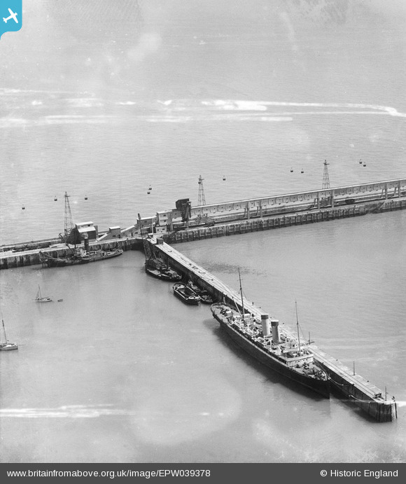
EPW039378 ENGLAND (1932). The Eastern Breakwater and boats moored alongside the South Jetty, Dover, 1932
© Copyright OpenStreetMap contributors and licensed by the OpenStreetMap Foundation. 2025. Cartography is licensed as CC BY-SA.
Nearby Images (2)
EPW039378

EPW039382

Details
| Title | [EPW039378] The Eastern Breakwater and boats moored alongside the South Jetty, Dover, 1932 |
| Reference | EPW039378 |
| Date | August-1932 |
| Link | |
| Place name | DOVER |
| Parish | DOVER |
| District | |
| Country | ENGLAND |
| Easting / Northing | 633991, 141686 |
| Longitude / Latitude | 1.3444403596065, 51.126053041392 |
| National Grid Reference | TR340417 |
Pins
 MB |
Monday 1st of April 2013 01:38:08 PM | |
An aerial ropeway was built in 1930 to link Tilmanstone pit with Dover Harbour. This included tunnelling through the cliff at Dover to deliver the coal to a 5,000 ton bunker at the harbour. It wasn't used much after 1935, and was dismantled in 1954. |
 Class31 |
Friday 12th of April 2013 11:21:44 AM |
MB |
Monday 1st of April 2013 01:37:39 PM | |
MB |
Monday 1st of April 2013 01:36:31 PM | |
MB |
Monday 1st of April 2013 01:35:42 PM |
User Comment Contributions
 Love the cable system in the background - for transporting coal? |
James Crawford |
Tuesday 2nd of April 2013 10:10:33 AM |