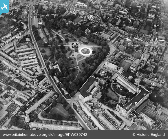
EPW039742 ENGLAND (1932). Chapelfield Gardens and the town centre, Norwich, 1932
© Copyright OpenStreetMap contributors and licensed by the OpenStreetMap Foundation. 2025. Cartography is licensed as CC BY-SA.
Nearby Images (10)
Details
| Title | [EPW039742] Chapelfield Gardens and the town centre, Norwich, 1932 |
| Reference | EPW039742 |
| Date | 23-July-1932 |
| Link | |
| Place name | NORWICH |
| Parish | |
| District | |
| Country | ENGLAND |
| Easting / Northing | 622620, 308319 |
| Longitude / Latitude | 1.2897053188756, 52.62654653364 |
| National Grid Reference | TG226083 |
Pins
 Chris Booty |
Monday 23rd of April 2018 12:29:13 PM | |
 Chris Booty |
Monday 23rd of April 2018 12:27:41 PM | |
 Andrew Wenley |
Wednesday 11th of April 2018 04:20:51 PM | |
 Andrew Wenley |
Wednesday 11th of April 2018 04:18:28 PM | |
 nikksie |
Tuesday 1st of March 2016 03:51:49 PM | |
 nikksie |
Tuesday 1st of March 2016 03:51:44 PM | |
 bugbear |
Friday 30th of August 2013 05:02:07 PM | |
 bugbear |
Friday 30th of August 2013 05:01:28 PM | |
 bugbear |
Monday 19th of August 2013 10:58:04 AM |
User Comment Contributions
Caleys chocolate factory |
 Dan Blanchflower |
Friday 20th of December 2013 08:03:55 PM |


![[EPW039742] Chapelfield Gardens and the town centre, Norwich, 1932](http://britainfromabove.org.uk/sites/all/libraries/aerofilms-images/public/100x100/EPW/039/EPW039742.jpg)
![[EPW052261] A.J. Caley and Sons Chapel Field Confectionery Works and environs, Norwich, 1936](http://britainfromabove.org.uk/sites/all/libraries/aerofilms-images/public/100x100/EPW/052/EPW052261.jpg)
![[EPW021204] The A. J. Caley & Son Ltd Confectionery Works, Norwich, 1928](http://britainfromabove.org.uk/sites/all/libraries/aerofilms-images/public/100x100/EPW/021/EPW021204.jpg)
![[EPW052260] A.J. Caley and Sons Chapel Field Confectionery Works and environs, Norwich, 1936](http://britainfromabove.org.uk/sites/all/libraries/aerofilms-images/public/100x100/EPW/052/EPW052260.jpg)
![[EPW021216] The A. J. Caley & Son Ltd Confectionery Works, Norwich, 1928](http://britainfromabove.org.uk/sites/all/libraries/aerofilms-images/public/100x100/EPW/021/EPW021216.jpg)
![[EPW021217] The A. J. Caley & Son Ltd Confectionery Works, Norwich, 1928](http://britainfromabove.org.uk/sites/all/libraries/aerofilms-images/public/100x100/EPW/021/EPW021217.jpg)
![[EPW052263] A.J. Caley and Sons Chapel Field Confectionery Works and environs, Norwich, 1936. This image has been produced from a damaged negative.](http://britainfromabove.org.uk/sites/all/libraries/aerofilms-images/public/100x100/EPW/052/EPW052263.jpg)
![[EPW052262] A.J. Caley and Sons Chapel Field Confectionery Works and environs, Norwich, 1936](http://britainfromabove.org.uk/sites/all/libraries/aerofilms-images/public/100x100/EPW/052/EPW052262.jpg)
![[EPW001971] Chapelfield Road and environs, Norwich, 1920](http://britainfromabove.org.uk/sites/all/libraries/aerofilms-images/public/100x100/EPW/001/EPW001971.jpg)
![[EAW005080] City Hall, the Fire Station and environs, Norwich, 1947](http://britainfromabove.org.uk/sites/all/libraries/aerofilms-images/public/100x100/EAW/005/EAW005080.jpg)