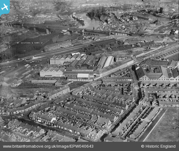
EPW040643 ENGLAND (1932). The Sunderland Forge and Engineering Co Ltd Works, Sunderland, 1932
© Copyright OpenStreetMap contributors and licensed by the OpenStreetMap Foundation. 2025. Cartography is licensed as CC BY-SA.
Nearby Images (6)
Details
| Title | [EPW040643] The Sunderland Forge and Engineering Co Ltd Works, Sunderland, 1932 |
| Reference | EPW040643 |
| Date | October-1932 |
| Link | |
| Place name | SUNDERLAND |
| Parish | |
| District | |
| Country | ENGLAND |
| Easting / Northing | 437849, 557377 |
| Longitude / Latitude | -1.4095845965193, 54.909586250602 |
| National Grid Reference | NZ378574 |
Pins
 PinzaC55 |
Friday 27th of March 2020 10:14:44 PM | |
 Alan |
Tuesday 2nd of January 2018 04:55:33 PM | |
 Alan |
Tuesday 2nd of January 2018 04:54:41 PM | |
 Alan |
Tuesday 2nd of January 2018 04:53:37 PM | |
 Coops |
Friday 11th of March 2016 04:09:58 PM | |
 Brigham |
Thursday 26th of November 2015 04:07:09 PM | |
 kevin n |
Tuesday 17th of December 2013 02:04:10 PM | |
 kevin n |
Tuesday 17th of December 2013 02:02:53 PM | |
 kevin n |
Tuesday 17th of December 2013 02:01:28 PM | |
Sir James Laing to be exact,established in the late 1700's. I finished my apprenticeship here in 1967. |
 Coops |
Friday 11th of March 2016 04:09:04 PM |
 Maurice |
Sunday 21st of July 2013 01:35:02 PM |


![[EPW040643] The Sunderland Forge and Engineering Co Ltd Works, Sunderland, 1932](http://britainfromabove.org.uk/sites/all/libraries/aerofilms-images/public/100x100/EPW/040/EPW040643.jpg)
![[EPW040646] The Sunderland Forge and Engineering Co Ltd Works, Sunderland, 1932](http://britainfromabove.org.uk/sites/all/libraries/aerofilms-images/public/100x100/EPW/040/EPW040646.jpg)
![[EPW040647] The Sunderland Forge and Engineering Co Ltd Works, Sunderland, 1932](http://britainfromabove.org.uk/sites/all/libraries/aerofilms-images/public/100x100/EPW/040/EPW040647.jpg)
![[EPW040644] The Sunderland Forge and Engineering Co Ltd Works, Sunderland, 1932](http://britainfromabove.org.uk/sites/all/libraries/aerofilms-images/public/100x100/EPW/040/EPW040644.jpg)
![[EPW040642] The Sunderland Forge and Engineering Co Ltd Works and John Lynn and Co St Luke's Engineering Works, Sunderland, 1932](http://britainfromabove.org.uk/sites/all/libraries/aerofilms-images/public/100x100/EPW/040/EPW040642.jpg)
![[EPW040645] The Sunderland Forge and Engineering Co Ltd Works, Sunderland, 1932](http://britainfromabove.org.uk/sites/all/libraries/aerofilms-images/public/100x100/EPW/040/EPW040645.jpg)