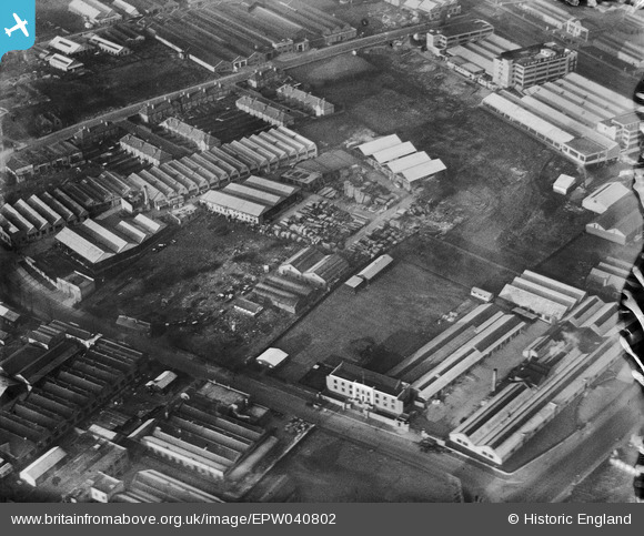
EPW040802 ENGLAND (1933). The Bovis Ltd Works, Kemps Biscuit Works and environs, Dollis Hill, 1933
© Copyright OpenStreetMap contributors and licensed by the OpenStreetMap Foundation. 2025. Cartography is licensed as CC BY-SA.
Nearby Images (18)
Details
| Title | [EPW040802] The Bovis Ltd Works, Kemps Biscuit Works and environs, Dollis Hill, 1933 |
| Reference | EPW040802 |
| Date | January-1933 |
| Link | |
| Place name | DOLLIS HILL |
| Parish | |
| District | |
| Country | ENGLAND |
| Easting / Northing | 522645, 186964 |
| Longitude / Latitude | -0.23024809452752, 51.567717896438 |
| National Grid Reference | TQ226870 |
Pins
Be the first to add a comment to this image!


![[EPW040802] The Bovis Ltd Works, Kemps Biscuit Works and environs, Dollis Hill, 1933](http://britainfromabove.org.uk/sites/all/libraries/aerofilms-images/public/100x100/EPW/040/EPW040802.jpg)
![[EPW040800] The Bovis Ltd Works, Kemps Biscuit Works and Brent Reservoir, Dollis Hill, 1933](http://britainfromabove.org.uk/sites/all/libraries/aerofilms-images/public/100x100/EPW/040/EPW040800.jpg)
![[EPW040804] The Bovis Ltd Works, Kemps Biscuit Works and environs, Dollis Hill, 1933](http://britainfromabove.org.uk/sites/all/libraries/aerofilms-images/public/100x100/EPW/040/EPW040804.jpg)
![[EPW040803] The Bovis Ltd Works, Kemps Biscuit Works and environs, Dollis Hill, 1933](http://britainfromabove.org.uk/sites/all/libraries/aerofilms-images/public/100x100/EPW/040/EPW040803.jpg)
![[EPW040801] The Bovis Ltd Works, Kemps Biscuit Works and environs, Dollis Hill, 1933](http://britainfromabove.org.uk/sites/all/libraries/aerofilms-images/public/100x100/EPW/040/EPW040801.jpg)
![[EPW040798] The Bovis Ltd Works, Kemps Biscuit Works and environs, Dollis Hill, 1933](http://britainfromabove.org.uk/sites/all/libraries/aerofilms-images/public/100x100/EPW/040/EPW040798.jpg)
![[EPW040799] The Bovis Ltd Works, Kemps Biscuit Works and environs, Dollis Hill, 1933. This image has been produced from a damaged negative.](http://britainfromabove.org.uk/sites/all/libraries/aerofilms-images/public/100x100/EPW/040/EPW040799.jpg)
![[EPW040806] The Bovis Ltd Works, Kemps Biscuit Works and environs, Dollis Hill, 1933](http://britainfromabove.org.uk/sites/all/libraries/aerofilms-images/public/100x100/EPW/040/EPW040806.jpg)
![[EPW040805] The Bovis Ltd Works, Crest Road and environs, Dollis Hill, 1933. This image has been produced from a damaged negative.](http://britainfromabove.org.uk/sites/all/libraries/aerofilms-images/public/100x100/EPW/040/EPW040805.jpg)
![[EPW013748] Staples Corner, Dollis Hill, 1925. This image has been produced from a copy-negative.](http://britainfromabove.org.uk/sites/all/libraries/aerofilms-images/public/100x100/EPW/013/EPW013748.jpg)
![[EPW032145] Scribbans-Kemp Biscuit Factory and environs, Dollis Hill, 1930](http://britainfromabove.org.uk/sites/all/libraries/aerofilms-images/public/100x100/EPW/032/EPW032145.jpg)
![[EPW057606] The Hendon Greyhound Racing Stadium and Kemps Biscuit Works off the North Circular Road and the surrounding area, Dollis Hill, 1938. This image has been produced from a copy-negative.](http://britainfromabove.org.uk/sites/all/libraries/aerofilms-images/public/100x100/EPW/057/EPW057606.jpg)
![[EPW032172] The Staples Mattress Factory and Staples Corner, Dollis Hill, 1930](http://britainfromabove.org.uk/sites/all/libraries/aerofilms-images/public/100x100/EPW/032/EPW032172.jpg)
![[EPW032171] The Staples Mattress Factory and Staples Corner, Dollis Hill, 1930](http://britainfromabove.org.uk/sites/all/libraries/aerofilms-images/public/100x100/EPW/032/EPW032171.jpg)
![[EPW038799] North Circular Road at Brent Bridge and environs, Golders Green, from the south-west, 1932](http://britainfromabove.org.uk/sites/all/libraries/aerofilms-images/public/100x100/EPW/038/EPW038799.jpg)
![[EPW032146] Scribbans-Kemp Biscuit Factory and environs, Dollis Hill, 1930](http://britainfromabove.org.uk/sites/all/libraries/aerofilms-images/public/100x100/EPW/032/EPW032146.jpg)
![[EPW032144] Scribbans-Kemp Biscuit Factory and environs, Dollis Hill, 1930](http://britainfromabove.org.uk/sites/all/libraries/aerofilms-images/public/100x100/EPW/032/EPW032144.jpg)
![[EPW050427] The Kemps Biscuit Factory on the North Circular Road, Dollis Hill, 1936](http://britainfromabove.org.uk/sites/all/libraries/aerofilms-images/public/100x100/EPW/050/EPW050427.jpg)