
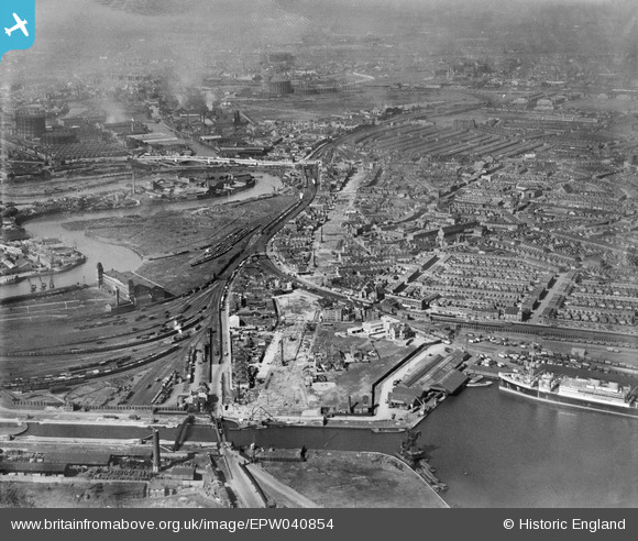
EPW040854 ENGLAND (1933). Slum clearance off the Victoria Dock Road and environs, Canning Town, 1933
© Copyright OpenStreetMap contributors and licensed by the OpenStreetMap Foundation. 2025. Cartography is licensed as CC BY-SA.
Nearby Images (6)
EPW040854

EPW059407

EPW040853

EPW046798

EPW059453

EPW059455

Details
| Title | [EPW040854] Slum clearance off the Victoria Dock Road and environs, Canning Town, 1933 |
| Reference | EPW040854 |
| Date | March-1933 |
| Link | |
| Place name | CANNING TOWN |
| Parish | |
| District | |
| Country | ENGLAND |
| Easting / Northing | 539745, 180977 |
| Longitude / Latitude | 0.01397136661141, 51.509934426874 |
| National Grid Reference | TQ397810 |
Pins
 Del |
Thursday 1st of June 2023 12:09:09 PM | |
Blake1 |
Sunday 25th of February 2018 05:20:23 PM | |
Blake1 |
Wednesday 25th of January 2017 12:43:31 AM | |
Blake1 |
Wednesday 25th of January 2017 12:40:47 AM | |
Blake1 |
Wednesday 25th of January 2017 12:39:55 AM | |
Blake1 |
Wednesday 25th of January 2017 12:38:44 AM | |
Blake1 |
Wednesday 25th of January 2017 12:37:31 AM | |
Blake1 |
Wednesday 25th of January 2017 12:34:58 AM | |
Blake1 |
Wednesday 25th of January 2017 12:31:26 AM | |
Blake1 |
Wednesday 25th of January 2017 12:29:02 AM | |
Blake1 |
Wednesday 25th of January 2017 12:25:57 AM | |
Blake1 |
Wednesday 25th of January 2017 12:22:14 AM | |
Blake1 |
Wednesday 25th of January 2017 12:18:01 AM | |
Blake1 |
Wednesday 25th of January 2017 12:16:42 AM | |
Blake1 |
Wednesday 25th of January 2017 12:14:30 AM | |
Blake1 |
Wednesday 25th of January 2017 12:13:06 AM | |
Blake1 |
Wednesday 25th of January 2017 12:11:18 AM | |
Blake1 |
Wednesday 25th of January 2017 12:09:54 AM | |
Blake1 |
Wednesday 25th of January 2017 12:08:56 AM | |
Blake1 |
Wednesday 25th of January 2017 12:07:03 AM | |
Blake1 |
Wednesday 25th of January 2017 12:04:34 AM | |
Blake1 |
Wednesday 25th of January 2017 12:02:58 AM | |
Blake1 |
Wednesday 25th of January 2017 12:01:16 AM | |
Blake1 |
Tuesday 24th of January 2017 11:59:49 PM | |
Blake1 |
Tuesday 24th of January 2017 11:58:47 PM | |
Blake1 |
Tuesday 24th of January 2017 11:57:41 PM | |
Blake1 |
Tuesday 24th of January 2017 11:54:01 PM | |
Blake1 |
Tuesday 24th of January 2017 11:52:57 PM | |
Blake1 |
Tuesday 24th of January 2017 11:49:47 PM | |
 Class31 |
Saturday 28th of February 2015 07:19:55 AM | |
Grollo |
Saturday 18th of October 2014 08:18:38 AM | |
Grollo |
Sunday 9th of March 2014 11:32:19 AM | |
Grollo |
Sunday 9th of March 2014 11:21:09 AM | |
Grollo |
Sunday 9th of March 2014 10:43:10 AM | |
Grollo |
Sunday 9th of March 2014 10:35:10 AM |

User Comment Contributions
Not only slum clearance but making room for the elevated 'Silvertown Way' - a road to improve connections with the docks and other local industries. |
John W |
Saturday 4th of February 2017 05:33:14 PM |
 I can just make out Holy Trinity church, Barking Road. Closed 1948 then demolished. |
Where's Canning Town? |
Sunday 2nd of February 2014 12:14:01 AM |
So much to see! The 'new' Silvertown Way viaduct can be seen under construction slicing its way almost north - south and designed to alleviate the traffic congestion on the old Victoria Dock Road (to the west) with its bridges and level crossings and that formed one of the main roads into the Victoria and Royal Albert Docks. This 1940 map extract covers some of this area; http://www.flickr.com/photos/36844288@N00/11527458604/ |
Mikeya |
Tuesday 24th of December 2013 08:01:54 AM |