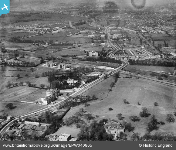
EPW040865 ENGLAND (1933). Hanger Hill, Hanger Lane and environs, Ealing, 1933
© Copyright OpenStreetMap contributors and licensed by the OpenStreetMap Foundation. 2025. Cartography is licensed as CC BY-SA.
Nearby Images (13)
Details
| Title | [EPW040865] Hanger Hill, Hanger Lane and environs, Ealing, 1933 |
| Reference | EPW040865 |
| Date | March-1933 |
| Link | |
| Place name | EALING |
| Parish | |
| District | |
| Country | ENGLAND |
| Easting / Northing | 518419, 182550 |
| Longitude / Latitude | -0.29268514707945, 51.528946478899 |
| National Grid Reference | TQ184826 |
Pins
 Leslie B |
Sunday 2nd of December 2018 01:28:48 AM |


![[EPW040865] Hanger Hill, Hanger Lane and environs, Ealing, 1933](http://britainfromabove.org.uk/sites/all/libraries/aerofilms-images/public/100x100/EPW/040/EPW040865.jpg)
![[EPW040863] Hanger Hill, Hanger Lane and environs, Ealing, 1933](http://britainfromabove.org.uk/sites/all/libraries/aerofilms-images/public/100x100/EPW/040/EPW040863.jpg)
![[EPW040772] The Virol Factory, Hanger Lane and Wellington House, Ealing, 1932. This image has been produced from a damaged negative.](http://britainfromabove.org.uk/sites/all/libraries/aerofilms-images/public/100x100/EPW/040/EPW040772.jpg)
![[EPW040873] Western Avenue and Hanger Hill, Ealing, 1933](http://britainfromabove.org.uk/sites/all/libraries/aerofilms-images/public/100x100/EPW/040/EPW040873.jpg)
![[EPW040874] Western Avenue and Hanger Hill, Ealing, 1933](http://britainfromabove.org.uk/sites/all/libraries/aerofilms-images/public/100x100/EPW/040/EPW040874.jpg)
![[EAW015158] Greystoke House, Sandall Close, Hanger Lane and environs, Ealing, 1948. This image has been produced from a print marked by Aerofilms Ltd for photo editing.](http://britainfromabove.org.uk/sites/all/libraries/aerofilms-images/public/100x100/EAW/015/EAW015158.jpg)
![[EPW040866] Hanger Hill and Hanger Lane, Ealing, 1933](http://britainfromabove.org.uk/sites/all/libraries/aerofilms-images/public/100x100/EPW/040/EPW040866.jpg)
![[EAW015160] Greystoke House and Hanger Lane, Ealing, 1948. This image has been produced from a print marked by Aerofilms Ltd for photo editing.](http://britainfromabove.org.uk/sites/all/libraries/aerofilms-images/public/100x100/EAW/015/EAW015160.jpg)
![[EAW015159] Greystoke House, Hanger Lane and environs, Ealing, 1948. This image was marked by Aerofilms Ltd for photo editing.](http://britainfromabove.org.uk/sites/all/libraries/aerofilms-images/public/100x100/EAW/015/EAW015159.jpg)
![[EPW025992] Fox Reservoir, Hanger Hill Park and Greystoke Court under construction, Ealing, 1929](http://britainfromabove.org.uk/sites/all/libraries/aerofilms-images/public/100x100/EPW/025/EPW025992.jpg)
![[EPW040864] Hanger Hill and Hanger Lane, Ealing, 1933](http://britainfromabove.org.uk/sites/all/libraries/aerofilms-images/public/100x100/EPW/040/EPW040864.jpg)
![[EAW015161] Greystoke House and Hanger Lane, Ealing, 1948. This image has been produced from a print marked by Aerofilms Ltd for photo editing.](http://britainfromabove.org.uk/sites/all/libraries/aerofilms-images/public/100x100/EAW/015/EAW015161.jpg)
![[EPW025997] Hanger Hill Park and environs, Ealing, 1929](http://britainfromabove.org.uk/sites/all/libraries/aerofilms-images/public/100x100/EPW/025/EPW025997.jpg)