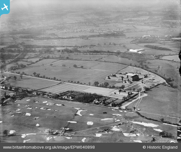
EPW040898 ENGLAND (1933). Sandy Lodge Golf Course, the Merchant Taylors' School and environs, Moor Park, from the south-east, 1933
© Copyright OpenStreetMap contributors and licensed by the OpenStreetMap Foundation. 2025. Cartography is licensed as CC BY-SA.
Details
| Title | [EPW040898] Sandy Lodge Golf Course, the Merchant Taylors' School and environs, Moor Park, from the south-east, 1933 |
| Reference | EPW040898 |
| Date | March-1933 |
| Link | |
| Place name | MOOR PARK |
| Parish | |
| District | |
| Country | ENGLAND |
| Easting / Northing | 509346, 193603 |
| Longitude / Latitude | -0.41999773548151, 51.630131876051 |
| National Grid Reference | TQ093936 |
Pins
 John Swain |
Friday 27th of September 2013 11:46:32 AM | |
 John Swain |
Friday 27th of September 2013 11:10:58 AM | |
 John Swain |
Friday 27th of September 2013 11:08:19 AM | |
 John Swain |
Friday 27th of September 2013 11:05:59 AM | |
 John Swain |
Friday 27th of September 2013 11:03:35 AM | |
 John Swain |
Friday 27th of September 2013 11:02:32 AM | |
 John Swain |
Friday 27th of September 2013 11:01:00 AM | |
 John Swain |
Friday 27th of September 2013 10:59:43 AM | |
 John Swain |
Friday 27th of September 2013 10:57:08 AM | |
 John Swain |
Friday 27th of September 2013 10:55:22 AM | |
 John Swain |
Friday 27th of September 2013 10:53:52 AM | |
 John Swain |
Friday 27th of September 2013 10:52:31 AM | |
 John Swain |
Friday 27th of September 2013 10:51:34 AM | |
 John Swain |
Friday 27th of September 2013 10:50:30 AM | |
 John Swain |
Friday 27th of September 2013 10:48:27 AM | |
 John Swain |
Friday 27th of September 2013 10:47:08 AM | |
 John Swain |
Friday 27th of September 2013 10:46:19 AM | |
 John Swain |
Friday 27th of September 2013 10:45:16 AM | |
 John Swain |
Friday 27th of September 2013 10:44:32 AM | |
 John Swain |
Friday 27th of September 2013 10:43:10 AM |
User Comment Contributions
 John Swain |
Friday 27th of September 2013 11:52:28 AM | |
Sandy Lodge is one of several courses in the area which were set up between 1910 and 1944. Sandy Lodge Golf Club was founded in 1910 and the course was designed by Harry Vardon, who also planned the neighbouring links at Oxhey. Merchant Taylors' School was built in 1933 on a spacious site of 256 acres, having successfully completed the move out of central London after years of debate. This image is one of a series undertaken by Aerofilms, on a crisp March afternoon, just as the school buildings were completed for the start of the Summer Term. The wet pit marked above would soon be filled by the first of the lakes at Hampermill by 1938 and a second was to follow in 1961. In the distance to the north-west, the first of many industrial concerns to be established along Tolpits Lane was the Universal Asbestos Manufacturing Company's works, the initial phase of which was completed by the end of 1930. Further expansion was to take place by 1939 and a railway siding was laid on the south side of the London Midland & Scottish (Rickmansworth Branch), just beyond the Croxley Mill siding junction. The siding into the west side of the Asbestos factory remained in place until the freight line was closed in 1968, but the Croxley Mill siding gained a reprieve until 1981 and so the factory on Tolpits Lane continued to be served by the Croxley Mill weekday train after its journey to the Mill. Both factories were closed in the 1980s as further evidence of the declining industrial base in the Watford District. However, both the independent school and the golf club continue to thrive! |
 John Swain |
Friday 27th of September 2013 11:45:50 AM |


![[EPW040898] Sandy Lodge Golf Course, the Merchant Taylors' School and environs, Moor Park, from the south-east, 1933](http://britainfromabove.org.uk/sites/all/libraries/aerofilms-images/public/100x100/EPW/040/EPW040898.jpg)
![[EPW031286] Sandy Lodge Golf Course, Northwood, 1930](http://britainfromabove.org.uk/sites/all/libraries/aerofilms-images/public/100x100/EPW/031/EPW031286.jpg)
![[EPW031467] Sandy Lodge Lane, Sandy Lodge Golf Course and Common Moor, Moor Park, from the south-east, 1930](http://britainfromabove.org.uk/sites/all/libraries/aerofilms-images/public/100x100/EPW/031/EPW031467.jpg)
![[EPW031468] Sandy Lodge Lane, Sandy Lodge Golf Course and Common Moor, Moor Park, 1930](http://britainfromabove.org.uk/sites/all/libraries/aerofilms-images/public/100x100/EPW/031/EPW031468.jpg)
