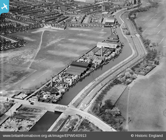
EPW040913 ENGLAND (1933). The G. Surrey Ltd Timber Yard, Marshgate Bridge and the River Lee Navigation, Homerton, 1933
© Copyright OpenStreetMap contributors and licensed by the OpenStreetMap Foundation. 2024. Cartography is licensed as CC BY-SA.
Nearby Images (16)
Details
| Title | [EPW040913] The G. Surrey Ltd Timber Yard, Marshgate Bridge and the River Lee Navigation, Homerton, 1933 |
| Reference | EPW040913 |
| Date | April-1933 |
| Link | |
| Place name | HOMERTON |
| Parish | |
| District | |
| Country | ENGLAND |
| Easting / Northing | 536545, 185583 |
| Longitude / Latitude | -0.030330390349568, 51.552111713938 |
| National Grid Reference | TQ365856 |
Pins
Be the first to add a comment to this image!


![[EPW040913] The G. Surrey Ltd Timber Yard, Marshgate Bridge and the River Lee Navigation, Homerton, 1933](http://britainfromabove.org.uk/sites/all/libraries/aerofilms-images/public/100x100/EPW/040/EPW040913.jpg)
![[EPW040914] The G. Surrey Ltd Timber Yard, Marshgate Bridge and the Hackney Marsh Recreation Grounds, Homerton, 1933](http://britainfromabove.org.uk/sites/all/libraries/aerofilms-images/public/100x100/EPW/040/EPW040914.jpg)
![[EPW040917] The G. Surrey Ltd Timber Yard, Marshgate Bridge and the River Lee Navigation, Homerton, 1933](http://britainfromabove.org.uk/sites/all/libraries/aerofilms-images/public/100x100/EPW/040/EPW040917.jpg)
![[EPW040912] The G. Surrey Ltd Timber Yard, Marshgate Bridge and the River Lee Navigation, Homerton, 1933](http://britainfromabove.org.uk/sites/all/libraries/aerofilms-images/public/100x100/EPW/040/EPW040912.jpg)
![[EPW040915] The G. Surrey Ltd Timber Yard, Marshgate Bridge and the River Lee Navigation, Homerton, 1933](http://britainfromabove.org.uk/sites/all/libraries/aerofilms-images/public/100x100/EPW/040/EPW040915.jpg)
![[EPW005649] Factories and wharves alongside the Hackney Cut Navigation, Hackney Marsh, 1921](http://britainfromabove.org.uk/sites/all/libraries/aerofilms-images/public/100x100/EPW/005/EPW005649.jpg)
![[EPW005647] Factories and wharves alongside the Hackney Cut Navigation, Hackney Marsh, 1921](http://britainfromabove.org.uk/sites/all/libraries/aerofilms-images/public/100x100/EPW/005/EPW005647.jpg)
![[EPW040916] The G. Surrey Ltd Timber Yard and the W. Could & Sons Saw Mill alongside the River Lee Navigation, Homerton, 1933](http://britainfromabove.org.uk/sites/all/libraries/aerofilms-images/public/100x100/EPW/040/EPW040916.jpg)
![[EPW044838] W Gould and Sons Wharf and Saw Mills on the Lee Navigation, Hackney, 1934. This image was marked by Aerofilms Ltd for photo editing.](http://britainfromabove.org.uk/sites/all/libraries/aerofilms-images/public/100x100/EPW/044/EPW044838.jpg)
![[EPW043987] The W. Gould & Sons Wharf and Saw Mill and the G. Surrey Ltd Timber Yard, Homerton, 1934](http://britainfromabove.org.uk/sites/all/libraries/aerofilms-images/public/100x100/EPW/043/EPW043987.jpg)
![[EPW043988] The W. Gould & Sons Wharf and Saw Mill and the G. Surrey Ltd Timber Yard, Homerton, 1934](http://britainfromabove.org.uk/sites/all/libraries/aerofilms-images/public/100x100/EPW/043/EPW043988.jpg)
![[EPW043990] The W. Gould & Sons Wharf and Saw Mill, the G. Surrey Ltd Timber Yard alongside the River Lee Navigation, Homerton, 1934](http://britainfromabove.org.uk/sites/all/libraries/aerofilms-images/public/100x100/EPW/043/EPW043990.jpg)
![[EPW044839] W Gould and Sons Wharf and Saw Mills on the Lee Navigation, Hackney, 1934](http://britainfromabove.org.uk/sites/all/libraries/aerofilms-images/public/100x100/EPW/044/EPW044839.jpg)
![[EPW044837] W Gould and Sons Wharf and Saw Mills on the Lee Navigation, Hackney, 1934](http://britainfromabove.org.uk/sites/all/libraries/aerofilms-images/public/100x100/EPW/044/EPW044837.jpg)
![[EPW043989] The W. Gould & Sons Wharf and Saw Mill, the G. Surrey Ltd Timber Yard and Wick Field, Homerton, 1934](http://britainfromabove.org.uk/sites/all/libraries/aerofilms-images/public/100x100/EPW/043/EPW043989.jpg)
![[EPW040918] The G. Surrey Ltd Timber Yard, Marshgate Bridge and the River Lee Navigation, Homerton, from the east, 1933](http://britainfromabove.org.uk/sites/all/libraries/aerofilms-images/public/100x100/EPW/040/EPW040918.jpg)