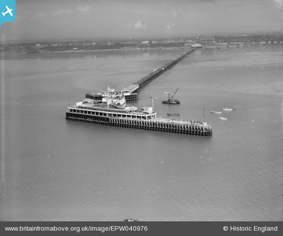
EPW040976 ENGLAND (1933). The Southend Pier, Southend-on-Sea, from the south, 1933
© Copyright OpenStreetMap contributors and licensed by the OpenStreetMap Foundation. 2025. Cartography is licensed as CC BY-SA.
Nearby Images (36)
Details
| Title | [EPW040976] The Southend Pier, Southend-on-Sea, from the south, 1933 |
| Reference | EPW040976 |
| Date | April-1933 |
| Link | |
| Place name | SOUTHEND-ON-SEA |
| Parish | |
| District | |
| Country | ENGLAND |
| Easting / Northing | 589007, 182974 |
| Longitude / Latitude | 0.72424351466287, 51.513543647112 |
| National Grid Reference | TQ890830 |
Pins
 bargee1937 |
Thursday 18th of June 2015 08:32:28 PM | |
 bargee1937 |
Sunday 5th of April 2015 05:11:20 PM |


![[EPW040976] The Southend Pier, Southend-on-Sea, from the south, 1933](http://britainfromabove.org.uk/sites/all/libraries/aerofilms-images/public/100x100/EPW/040/EPW040976.jpg)
![[EAW017030] The Southend Pier Prince George Extension, Southend-on-Sea, from the south, 1948. This image has been produced from a print.](http://britainfromabove.org.uk/sites/all/libraries/aerofilms-images/public/100x100/EAW/017/EAW017030.jpg)
![[EPW062734] The Royal Eagle Paddle Steamer and the Moelfre Rose alongside Southend Pier, Southend-on-Sea, from the south, 1939](http://britainfromabove.org.uk/sites/all/libraries/aerofilms-images/public/100x100/EPW/062/EPW062734.jpg)
![[EAW026905] Southend Pier, Southend-on-Sea, from the south-east, 1949. This image has been produced from a damaged negative.](http://britainfromabove.org.uk/sites/all/libraries/aerofilms-images/public/100x100/EAW/026/EAW026905.jpg)
![[EAW038547] The Pier Extension, Southend-on-Sea, 1951. This image has been produced from a copy-negative.](http://britainfromabove.org.uk/sites/all/libraries/aerofilms-images/public/100x100/EAW/038/EAW038547.jpg)
![[EPW062736] The Royal Eagle Paddle Steamer alongside Southend Pier, Southend-on-Sea, from the south, 1939](http://britainfromabove.org.uk/sites/all/libraries/aerofilms-images/public/100x100/EPW/062/EPW062736.jpg)
![[EAW017027] The Southend Pier Prince George Extension, Southend-on-Sea, from the south, 1948. This image has been produced from a print.](http://britainfromabove.org.uk/sites/all/libraries/aerofilms-images/public/100x100/EAW/017/EAW017027.jpg)
![[EAW002215] Paddle Steamer and crowds at the Pier Extension, Southend-on-Sea, 1946](http://britainfromabove.org.uk/sites/all/libraries/aerofilms-images/public/100x100/EAW/002/EAW002215.jpg)
![[EAW017028] The Southend Pier Prince George Extension, Southend-on-Sea, from the south-east, 1948. This image has been produced from a print.](http://britainfromabove.org.uk/sites/all/libraries/aerofilms-images/public/100x100/EAW/017/EAW017028.jpg)
![[EAW026940] The Southend Pier Prince George Extension, Southend-on-Sea, from the south-west, 1949](http://britainfromabove.org.uk/sites/all/libraries/aerofilms-images/public/100x100/EAW/026/EAW026940.jpg)
![[EPW062735] The Royal Eagle Paddle Steamer alongside Southend Pier, Southend-on-Sea, from the south-east, 1939](http://britainfromabove.org.uk/sites/all/libraries/aerofilms-images/public/100x100/EPW/062/EPW062735.jpg)
![[EAW026938] The Southend Pier Prince George Extension, Southend-on-Sea, from the south-west, 1949](http://britainfromabove.org.uk/sites/all/libraries/aerofilms-images/public/100x100/EAW/026/EAW026938.jpg)
![[EAW026900] The Southend Pier Prince George Extension, Southend-on-Sea, from the south-west, 1949. This image was marked by Aerofilms Ltd for photo editing.](http://britainfromabove.org.uk/sites/all/libraries/aerofilms-images/public/100x100/EAW/026/EAW026900.jpg)
![[EAW038548] The Pier and Prince George Extensions to Southend Pier, Southend-on-Sea, 1951. This image has been produced from a copy-negative.](http://britainfromabove.org.uk/sites/all/libraries/aerofilms-images/public/100x100/EAW/038/EAW038548.jpg)
![[EAW026903] Southend Pier, Southend-on-Sea, from the south, 1949. This image was marked by Aerofilms Ltd for photo editing.](http://britainfromabove.org.uk/sites/all/libraries/aerofilms-images/public/100x100/EAW/026/EAW026903.jpg)
![[EPW040977] The Southend Pier Extension, Southend-on-Sea, from the south-west, 1933](http://britainfromabove.org.uk/sites/all/libraries/aerofilms-images/public/100x100/EPW/040/EPW040977.jpg)
![[EPW024882] Southend old pier head and pier extension under construction, Southend-on-Sea, 1928](http://britainfromabove.org.uk/sites/all/libraries/aerofilms-images/public/100x100/EPW/024/EPW024882.jpg)
![[EPW062737] The Royal Eagle Paddle Steamer alongside Southend Pier, Southend-on-Sea, from the south, 1939. This image has been produced from a damaged negative.](http://britainfromabove.org.uk/sites/all/libraries/aerofilms-images/public/100x100/EPW/062/EPW062737.jpg)
![[EAW026902] Southend Pier, Southend-on-Sea, from the south-east, 1949. This image was marked by Aerofilms Ltd for photo editing.](http://britainfromabove.org.uk/sites/all/libraries/aerofilms-images/public/100x100/EAW/026/EAW026902.jpg)
![[EAW002216] Paddle Steamer and crowds at the Pier Extension, Southend-on-Sea, 1946](http://britainfromabove.org.uk/sites/all/libraries/aerofilms-images/public/100x100/EAW/002/EAW002216.jpg)
![[EAW017026] Southend Pier, Southend-on-Sea, from the south, 1948. This image has been produced from a damaged print.](http://britainfromabove.org.uk/sites/all/libraries/aerofilms-images/public/100x100/EAW/017/EAW017026.jpg)
![[EPW036622] Southend Pier, Southend-on-Sea, 1931](http://britainfromabove.org.uk/sites/all/libraries/aerofilms-images/public/100x100/EPW/036/EPW036622.jpg)
![[EAW026904] Southend Pier, Southend-on-Sea, from the south-east, 1949. This image has been produced from a damaged negative.](http://britainfromabove.org.uk/sites/all/libraries/aerofilms-images/public/100x100/EAW/026/EAW026904.jpg)
![[EPW024880] Southend old pier head and pier extension, Southend-on-Sea, 1928](http://britainfromabove.org.uk/sites/all/libraries/aerofilms-images/public/100x100/EPW/024/EPW024880.jpg)
![[EAW026939] Southend Pier, Southend-on-Sea, from the south-west, 1949](http://britainfromabove.org.uk/sites/all/libraries/aerofilms-images/public/100x100/EAW/026/EAW026939.jpg)
![[EAW017029] The Southend Pier Prince George Extension, Southend-on-Sea, from the south, 1948. This image has been produced from a print.](http://britainfromabove.org.uk/sites/all/libraries/aerofilms-images/public/100x100/EAW/017/EAW017029.jpg)
![[EAW042706] The Pier Extension, Southend-on-Sea, 1952](http://britainfromabove.org.uk/sites/all/libraries/aerofilms-images/public/100x100/EAW/042/EAW042706.jpg)
![[EPW000446] Southend Pier Extension, Southend-on-Sea, 1920](http://britainfromabove.org.uk/sites/all/libraries/aerofilms-images/public/100x100/EPW/000/EPW000446.jpg)
![[EAW026937] Southend Pier, Southend-on-Sea, from the south-east, 1949](http://britainfromabove.org.uk/sites/all/libraries/aerofilms-images/public/100x100/EAW/026/EAW026937.jpg)
![[EAW026901] Southend Pier, Southend-on-Sea, from the south-west, 1949. This image was marked by Aerofilms Ltd for photo editing.](http://britainfromabove.org.uk/sites/all/libraries/aerofilms-images/public/100x100/EAW/026/EAW026901.jpg)
![[EAW054228] The Old Pier Head and the Pier Extension, Southend-on-Sea, 1954](http://britainfromabove.org.uk/sites/all/libraries/aerofilms-images/public/100x100/EAW/054/EAW054228.jpg)
![[EAW042705] The Old Pier Head, Southend-on-Sea, 1952](http://britainfromabove.org.uk/sites/all/libraries/aerofilms-images/public/100x100/EAW/042/EAW042705.jpg)
![[EAW002214] The pier, Old Pier Head and Pier Extension, Southend-on-Sea, 1946](http://britainfromabove.org.uk/sites/all/libraries/aerofilms-images/public/100x100/EAW/002/EAW002214.jpg)
![[EPW000561] Southend Pier, Southend-on-Sea, from the south, 1920](http://britainfromabove.org.uk/sites/all/libraries/aerofilms-images/public/100x100/EPW/000/EPW000561.jpg)
![[EPW036623] Southend Pier, Southend-on-Sea, 1931](http://britainfromabove.org.uk/sites/all/libraries/aerofilms-images/public/100x100/EPW/036/EPW036623.jpg)
![[EPW000445] Southend Pier, Southend-on-Sea, from the south, 1920](http://britainfromabove.org.uk/sites/all/libraries/aerofilms-images/public/100x100/EPW/000/EPW000445.jpg)