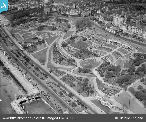
EPW040980 ENGLAND (1933). The Cifffs, Southend-on-Sea, 1933
© Copyright OpenStreetMap contributors and licensed by the OpenStreetMap Foundation. 2025. Cartography is licensed as CC BY-SA.
Nearby Images (27)
Details
| Title | [EPW040980] The Cifffs, Southend-on-Sea, 1933 |
| Reference | EPW040980 |
| Date | April-1933 |
| Link | |
| Place name | SOUTHEND-ON-SEA |
| Parish | |
| District | |
| Country | ENGLAND |
| Easting / Northing | 587417, 185151 |
| Longitude / Latitude | 0.70251179546969, 51.533628179082 |
| National Grid Reference | TQ874852 |
Pins
Be the first to add a comment to this image!


![[EPW040980] The Cifffs, Southend-on-Sea, 1933](http://britainfromabove.org.uk/sites/all/libraries/aerofilms-images/public/100x100/EPW/040/EPW040980.jpg)
![[EPW040968] Outdoor Swimming Baths by The Cliffs and the town, Southend-on-Sea, 1933](http://britainfromabove.org.uk/sites/all/libraries/aerofilms-images/public/100x100/EPW/040/EPW040968.jpg)
![[EAW053091] Cliff Gardens and Westcliff Parade, Southend-on-Sea, 1954](http://britainfromabove.org.uk/sites/all/libraries/aerofilms-images/public/100x100/EAW/053/EAW053091.jpg)
![[EAW002197] Southend Seawater Swimming Bath and The Cliffs on Western Esplanade, Southend-on-Sea, 1946](http://britainfromabove.org.uk/sites/all/libraries/aerofilms-images/public/100x100/EAW/002/EAW002197.jpg)
![[EPW036994] The Swimming Baths and The Cliffs, Clifftown, 1931](http://britainfromabove.org.uk/sites/all/libraries/aerofilms-images/public/100x100/EPW/036/EPW036994.jpg)
![[EAW002196] Southend Seawater Swimming Bath and The Cliffs on Western Esplanade and environs, Southend-on-Sea, 1946](http://britainfromabove.org.uk/sites/all/libraries/aerofilms-images/public/100x100/EAW/002/EAW002196.jpg)
![[EPW036713] The Western Esplanade Swimming Baths, The Cliffs and the town, Southend-on-Sea, from the south, 1931](http://britainfromabove.org.uk/sites/all/libraries/aerofilms-images/public/100x100/EPW/036/EPW036713.jpg)
![[EPW032905] The Cliffs and environs, Clifftown, 1930](http://britainfromabove.org.uk/sites/all/libraries/aerofilms-images/public/100x100/EPW/032/EPW032905.jpg)
![[EAW002195] Southend Seawater Swimming Bath and The Cliffs on Western Esplanade, Southend-on-Sea, 1946](http://britainfromabove.org.uk/sites/all/libraries/aerofilms-images/public/100x100/EAW/002/EAW002195.jpg)
![[EPW024862] The Westcliff sea water swimming bath, Southend-on-Sea, 1928](http://britainfromabove.org.uk/sites/all/libraries/aerofilms-images/public/100x100/EPW/024/EPW024862.jpg)
![[EPW036740] The Western Esplanade Swimming Baths, The Cliffs and environs, Southend-on-Sea, 1931](http://britainfromabove.org.uk/sites/all/libraries/aerofilms-images/public/100x100/EPW/036/EPW036740.jpg)
![[EPW036991] Westcliff Parade, The Cliffs and environs, Westcliff-on-Sea, from the south-west, 1931](http://britainfromabove.org.uk/sites/all/libraries/aerofilms-images/public/100x100/EPW/036/EPW036991.jpg)
![[EPW036728] The Western Esplanade, The Cliffs and Westcliff Parade, Southend-on-Sea, 1931](http://britainfromabove.org.uk/sites/all/libraries/aerofilms-images/public/100x100/EPW/036/EPW036728.jpg)
![[EPW024861] Westcliff Parade and environs, Southend-on-Sea, 1928](http://britainfromabove.org.uk/sites/all/libraries/aerofilms-images/public/100x100/EPW/024/EPW024861.jpg)
![[EPW024866] Nore Yacht Club and cliff gardens to the west, Southend-on-Sea, 1928](http://britainfromabove.org.uk/sites/all/libraries/aerofilms-images/public/100x100/EPW/024/EPW024866.jpg)
![[EAW053090] The Westcliff sea water swimming bath, Southend-on-Sea, from the south, 1954](http://britainfromabove.org.uk/sites/all/libraries/aerofilms-images/public/100x100/EAW/053/EAW053090.jpg)
![[EPW039869] The Cliffs and environs, Southend-on-Sea, 1932](http://britainfromabove.org.uk/sites/all/libraries/aerofilms-images/public/100x100/EPW/039/EPW039869.jpg)
![[EPW054670] Southend Seawater Swimming Bath and The Cliffs, Clifftown, 1937](http://britainfromabove.org.uk/sites/all/libraries/aerofilms-images/public/100x100/EPW/054/EPW054670.jpg)
![[EPW000449] Clifftown, Southend-on-Sea, 1920](http://britainfromabove.org.uk/sites/all/libraries/aerofilms-images/public/100x100/EPW/000/EPW000449.jpg)
![[EPW054676] Westcliff Parade and The Cliffs, Westcliff-on-Sea, 1937](http://britainfromabove.org.uk/sites/all/libraries/aerofilms-images/public/100x100/EPW/054/EPW054676.jpg)
![[EPW040984] The Western Esplanade Swimming Baths, The Cliffs and Clifftown, Southend-on-Sea, from the south-east, 1933](http://britainfromabove.org.uk/sites/all/libraries/aerofilms-images/public/100x100/EPW/040/EPW040984.jpg)
![[EPW058504] The Cliffs Pavilion under construction, Westcliff-on-Sea, 1938](http://britainfromabove.org.uk/sites/all/libraries/aerofilms-images/public/100x100/EPW/058/EPW058504.jpg)
![[EPW036992] The Padding Pool, The Cliffs and environs, Westcliff-on-Sea, from the south-west, 1931](http://britainfromabove.org.uk/sites/all/libraries/aerofilms-images/public/100x100/EPW/036/EPW036992.jpg)
![[EPW036739] The Western Esplanade, The Cliffs and the Clifftown Parade War Memorial, Southend-on-Sea, 1931](http://britainfromabove.org.uk/sites/all/libraries/aerofilms-images/public/100x100/EPW/036/EPW036739.jpg)
![[EPW000447] Clifftown, Southend-on-Sea, from the south-west, 1920](http://britainfromabove.org.uk/sites/all/libraries/aerofilms-images/public/100x100/EPW/000/EPW000447.jpg)
![[EPW036993] The Cliffs and environs, Clifftown, from the south, 1931](http://britainfromabove.org.uk/sites/all/libraries/aerofilms-images/public/100x100/EPW/036/EPW036993.jpg)
![[EPW000562] Westcliff-on-Sea, Southend-on-Sea, from the south-east, 1920](http://britainfromabove.org.uk/sites/all/libraries/aerofilms-images/public/100x100/EPW/000/EPW000562.jpg)