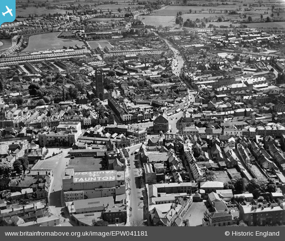
EPW041181 ENGLAND (1933). Fore Street and the town centre, Taunton, 1933
© Copyright OpenStreetMap contributors and licensed by the OpenStreetMap Foundation. 2025. Cartography is licensed as CC BY-SA.
Nearby Images (29)
Details
| Title | [EPW041181] Fore Street and the town centre, Taunton, 1933 |
| Reference | EPW041181 |
| Date | May-1933 |
| Link | |
| Place name | TAUNTON |
| Parish | |
| District | |
| Country | ENGLAND |
| Easting / Northing | 322756, 124528 |
| Longitude / Latitude | -3.1012790961226, 51.014397241516 |
| National Grid Reference | ST228245 |
Pins
 Class31 |
Saturday 16th of May 2015 11:14:52 PM | |
 Class31 |
Saturday 16th of May 2015 12:51:13 PM | |
 John Wass |
Friday 5th of December 2014 07:22:45 PM | |
 Applecounty |
Thursday 14th of August 2014 11:15:34 PM |
User Comment Contributions
The Parish Church of Saint Mary Magdalen, Church Square, Taunton, 12/05/2015 |
 Class31 |
Saturday 16th of May 2015 12:49:42 PM |


![[EPW041181] Fore Street and the town centre, Taunton, 1933](http://britainfromabove.org.uk/sites/all/libraries/aerofilms-images/public/100x100/EPW/041/EPW041181.jpg)
![[EPW027899] The town centre, Taunton, 1929. This image has been produced from a print.](http://britainfromabove.org.uk/sites/all/libraries/aerofilms-images/public/100x100/EPW/027/EPW027899.jpg)
![[EPW027893] The town centre, Taunton, 1929. This image has been produced from a print.](http://britainfromabove.org.uk/sites/all/libraries/aerofilms-images/public/100x100/EPW/027/EPW027893.jpg)
![[EAW005347] The town, Taunton, 1947](http://britainfromabove.org.uk/sites/all/libraries/aerofilms-images/public/100x100/EAW/005/EAW005347.jpg)
![[EPW013541] The Market House, Fore Street and environs, Taunton, 1925. This image has been produced from a copy-negative.](http://britainfromabove.org.uk/sites/all/libraries/aerofilms-images/public/100x100/EPW/013/EPW013541.jpg)
![[EAW005346] The town, Taunton, 1947](http://britainfromabove.org.uk/sites/all/libraries/aerofilms-images/public/100x100/EAW/005/EAW005346.jpg)
![[EAW051944] The town centre, Taunton, 1953](http://britainfromabove.org.uk/sites/all/libraries/aerofilms-images/public/100x100/EAW/051/EAW051944.jpg)
![[EAW051943] The town centre, Taunton, 1953. This image was marked by Aerofilms Ltd for photo editing.](http://britainfromabove.org.uk/sites/all/libraries/aerofilms-images/public/100x100/EAW/051/EAW051943.jpg)
![[EPW027885] St Mary Magdalen's Church and the town centre, Taunton, 1929. This image has been produced from a copy-negative.](http://britainfromabove.org.uk/sites/all/libraries/aerofilms-images/public/100x100/EPW/027/EPW027885.jpg)
![[EPW027886] North Street, the Cattle Market and the town centre, Taunton, 1929. This image has been produced from a copy-negative.](http://britainfromabove.org.uk/sites/all/libraries/aerofilms-images/public/100x100/EPW/027/EPW027886.jpg)
![[EAW051947] The town centre, Taunton, 1953. This image was marked by Aerofilms Ltd for photo editing.](http://britainfromabove.org.uk/sites/all/libraries/aerofilms-images/public/100x100/EAW/051/EAW051947.jpg)
![[EAW051941] The town centre, Taunton, 1953. This image was marked by Aerofilms Ltd for photo editing.](http://britainfromabove.org.uk/sites/all/libraries/aerofilms-images/public/100x100/EAW/051/EAW051941.jpg)
![[EPW041093] North Street and excavation at the Castle Hotel, Taunton, 1933](http://britainfromabove.org.uk/sites/all/libraries/aerofilms-images/public/100x100/EPW/041/EPW041093.jpg)
![[EPW041184] Castle Green and the Castle Hotel, Taunton, 1933](http://britainfromabove.org.uk/sites/all/libraries/aerofilms-images/public/100x100/EPW/041/EPW041184.jpg)
![[EPW041094] North Street and excavation at the Castle Hotel, Taunton, 1933](http://britainfromabove.org.uk/sites/all/libraries/aerofilms-images/public/100x100/EPW/041/EPW041094.jpg)
![[EAW005343] St Mary Magdalen's Church, Taunton, 1947](http://britainfromabove.org.uk/sites/all/libraries/aerofilms-images/public/100x100/EAW/005/EAW005343.jpg)
![[EPW041183] Castle Green and excavation at the Castle Hotel, Taunton, 1933](http://britainfromabove.org.uk/sites/all/libraries/aerofilms-images/public/100x100/EPW/041/EPW041183.jpg)
![[EPW013539] St Mary Magdalen's Church and East Street, Taunton, 1925. This image has been produced from a print affected by flare.](http://britainfromabove.org.uk/sites/all/libraries/aerofilms-images/public/100x100/EPW/013/EPW013539.jpg)
![[EAW005339] The remains of Taunton Castle and environs, Taunton, 1947. This image has been produced from a print.](http://britainfromabove.org.uk/sites/all/libraries/aerofilms-images/public/100x100/EAW/005/EAW005339.jpg)
![[EAW005342] The remains of Taunton Castle and environs, Taunton, 1947. This image has been produced from a print.](http://britainfromabove.org.uk/sites/all/libraries/aerofilms-images/public/100x100/EAW/005/EAW005342.jpg)
![[EAW005341] The remains of Taunton Castle, Taunton, 1947](http://britainfromabove.org.uk/sites/all/libraries/aerofilms-images/public/100x100/EAW/005/EAW005341.jpg)
![[EAW005337] The remains of Taunton Castle, Taunton, 1947. This image has been produced from a print.](http://britainfromabove.org.uk/sites/all/libraries/aerofilms-images/public/100x100/EAW/005/EAW005337.jpg)
![[EAW015036] The town, Taunton, from the south, 1948. This image has been produced from a print.](http://britainfromabove.org.uk/sites/all/libraries/aerofilms-images/public/100x100/EAW/015/EAW015036.jpg)
![[EAW005340] The remains of Taunton Castle, Taunton, 1947](http://britainfromabove.org.uk/sites/all/libraries/aerofilms-images/public/100x100/EAW/005/EAW005340.jpg)
![[EPW041182] The Gaumont Palace Cinema and Corporation Street, Taunton, 1933](http://britainfromabove.org.uk/sites/all/libraries/aerofilms-images/public/100x100/EPW/041/EPW041182.jpg)
![[EAW051945] The town centre, Taunton, 1953. This image was marked by Aerofilms Ltd for photo editing.](http://britainfromabove.org.uk/sites/all/libraries/aerofilms-images/public/100x100/EAW/051/EAW051945.jpg)
![[EAW005338] The remains of Taunton Castle and environs, Taunton, 1947. This image has been produced from a print.](http://britainfromabove.org.uk/sites/all/libraries/aerofilms-images/public/100x100/EAW/005/EAW005338.jpg)
![[EPW027892] The town centre, Taunton, 1929. This image has been produced from a print.](http://britainfromabove.org.uk/sites/all/libraries/aerofilms-images/public/100x100/EPW/027/EPW027892.jpg)
![[EAW051946] The town centre, Taunton, 1953](http://britainfromabove.org.uk/sites/all/libraries/aerofilms-images/public/100x100/EAW/051/EAW051946.jpg)