
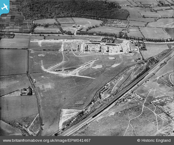
EPW041467 ENGLAND (1933). New housing under construction along Hall Road, Handsworth, 1933
© Copyright OpenStreetMap contributors and licensed by the OpenStreetMap Foundation. 2025. Cartography is licensed as CC BY-SA.
Nearby Images (6)
EPW041467

EPW041463

EPW041470

EPW041464

EPW041469

EPW041465

Details
| Title | [EPW041467] New housing under construction along Hall Road, Handsworth, 1933 |
| Reference | EPW041467 |
| Date | June-1933 |
| Link | |
| Place name | HANDSWORTH |
| Parish | |
| District | |
| Country | ENGLAND |
| Easting / Northing | 440351, 387386 |
| Longitude / Latitude | -1.3933141461033, 53.381516315253 |
| National Grid Reference | SK404874 |
Pins
 Ian D |
Friday 17th of January 2020 11:40:00 AM | |
ambergirls |
Saturday 16th of November 2013 08:28:22 AM | |
ambergirls |
Saturday 16th of November 2013 08:27:29 AM | |
ambergirls |
Saturday 16th of November 2013 08:26:48 AM | |
ambergirls |
Saturday 16th of November 2013 08:26:06 AM | |
ambergirls |
Wednesday 13th of November 2013 01:33:01 PM |