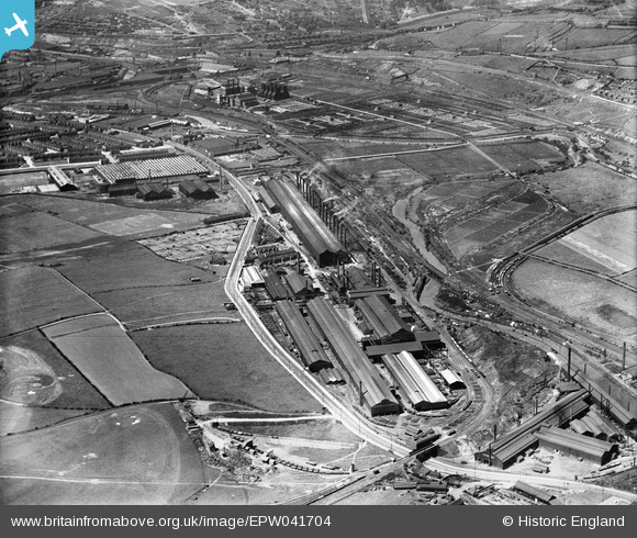
EPW041704 ENGLAND (1933). The Templeborough Steel Works alongside the River Don, Rotherham, 1933
© Copyright OpenStreetMap contributors and licensed by the OpenStreetMap Foundation. 2025. Cartography is licensed as CC BY-SA.
Nearby Images (17)
Details
| Title | [EPW041704] The Templeborough Steel Works alongside the River Don, Rotherham, 1933 |
| Reference | EPW041704 |
| Date | June-1933 |
| Link | |
| Place name | ROTHERHAM |
| Parish | |
| District | |
| Country | ENGLAND |
| Easting / Northing | 440986, 391543 |
| Longitude / Latitude | -1.3832272567936, 53.418835073207 |
| National Grid Reference | SK410915 |


![[EPW041704] The Templeborough Steel Works alongside the River Don, Rotherham, 1933](http://britainfromabove.org.uk/sites/all/libraries/aerofilms-images/public/100x100/EPW/041/EPW041704.jpg)
![[EAW030483] The Steel, Peech and Tozer Templeborough Steel Works and environs, Templeborough, 1950](http://britainfromabove.org.uk/sites/all/libraries/aerofilms-images/public/100x100/EAW/030/EAW030483.jpg)
![[EPW041706] The Templeborough Steel Works alongside the River Don, Rotherham, 1933](http://britainfromabove.org.uk/sites/all/libraries/aerofilms-images/public/100x100/EPW/041/EPW041706.jpg)
![[EAW030484] The Steel, Peech and Tozer Templeborough Steel Works and environs, Templeborough, 1950](http://britainfromabove.org.uk/sites/all/libraries/aerofilms-images/public/100x100/EAW/030/EAW030484.jpg)
![[EPW041702] The Templeborough Steel Works and environs, Rotherham, 1933](http://britainfromabove.org.uk/sites/all/libraries/aerofilms-images/public/100x100/EPW/041/EPW041702.jpg)
![[EPW015447] Templeborough Steel Works, Templeborough, 1926](http://britainfromabove.org.uk/sites/all/libraries/aerofilms-images/public/100x100/EPW/015/EPW015447.jpg)
![[EAW030480] The Steel, Peech and Tozer Templeborough Steel Works and environs, Templeborough, 1950](http://britainfromabove.org.uk/sites/all/libraries/aerofilms-images/public/100x100/EAW/030/EAW030480.jpg)
![[EAW025973] The Templeborough Steel Works, Templeborough, 1949. This image has been produced from a print marked by Aerofilms Ltd for photo editing.](http://britainfromabove.org.uk/sites/all/libraries/aerofilms-images/public/100x100/EAW/025/EAW025973.jpg)
![[EAW030490] The Steel, Peech and Tozer Templeborough Steel Works and environs, Templeborough, 1950](http://britainfromabove.org.uk/sites/all/libraries/aerofilms-images/public/100x100/EAW/030/EAW030490.jpg)
![[EAW030482] The Steel, Peech and Tozer Templeborough Steel Works and environs, Templeborough, 1950](http://britainfromabove.org.uk/sites/all/libraries/aerofilms-images/public/100x100/EAW/030/EAW030482.jpg)
![[EAW024151] The Steel, Peech and Tozer Templeborough Steel Works and Rolling Mills, Templeborough, from the south-east, 1949](http://britainfromabove.org.uk/sites/all/libraries/aerofilms-images/public/100x100/EAW/024/EAW024151.jpg)
![[EAW030481] The Steel, Peech and Tozer Templeborough Steel Works and environs, Magna, 1950](http://britainfromabove.org.uk/sites/all/libraries/aerofilms-images/public/100x100/EAW/030/EAW030481.jpg)
![[EPW041707] The Templeborough Steel Works and environs, Rotherham, 1933](http://britainfromabove.org.uk/sites/all/libraries/aerofilms-images/public/100x100/EPW/041/EPW041707.jpg)
![[EAW025969] The Templeborough Steel Works, Templeborough, 1949. This image has been produced from a print.](http://britainfromabove.org.uk/sites/all/libraries/aerofilms-images/public/100x100/EAW/025/EAW025969.jpg)
![[EAW030491] The Steel, Peech and Tozer Templeborough Steel Works, Templeborough, 1950](http://britainfromabove.org.uk/sites/all/libraries/aerofilms-images/public/100x100/EAW/030/EAW030491.jpg)
![[EAW030493] The Steel, Peech and Tozer Templeborough Steel Works and environs, Templeborough, 1950](http://britainfromabove.org.uk/sites/all/libraries/aerofilms-images/public/100x100/EAW/030/EAW030493.jpg)
![[EPW041701] The Templeborough Steel Works alongside the River Don, Rotherham, 1933](http://britainfromabove.org.uk/sites/all/libraries/aerofilms-images/public/100x100/EPW/041/EPW041701.jpg)