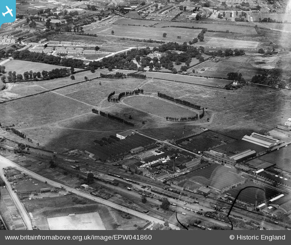
EPW041860 ENGLAND (1933). The Horse Ring football ground, Park Royal, 1933. This image has been produced from a damaged negative.
© Copyright OpenStreetMap contributors and licensed by the OpenStreetMap Foundation. 2025. Cartography is licensed as CC BY-SA.
Nearby Images (48)
Details
| Title | [EPW041860] The Horse Ring football ground, Park Royal, 1933. This image has been produced from a damaged negative. |
| Reference | EPW041860 |
| Date | June-1933 |
| Link | |
| Place name | PARK ROYAL |
| Parish | |
| District | |
| Country | ENGLAND |
| Easting / Northing | 519443, 182772 |
| Longitude / Latitude | -0.2778533869773, 51.530726180035 |
| National Grid Reference | TQ194828 |
Pins
 Class31 |
Wednesday 19th of August 2015 09:17:40 AM |


![[EPW041860] The Horse Ring football ground, Park Royal, 1933. This image has been produced from a damaged negative.](http://britainfromabove.org.uk/sites/all/libraries/aerofilms-images/public/100x100/EPW/041/EPW041860.jpg)
![[EPW041857] The Horse Ring football ground, Park Royal, 1933](http://britainfromabove.org.uk/sites/all/libraries/aerofilms-images/public/100x100/EPW/041/EPW041857.jpg)
![[EPW041850] The Horse Ring football ground, Park Royal, 1933](http://britainfromabove.org.uk/sites/all/libraries/aerofilms-images/public/100x100/EPW/041/EPW041850.jpg)
![[EPW048435] The Guinness Brewery under construction, Park Royal, 1935](http://britainfromabove.org.uk/sites/all/libraries/aerofilms-images/public/100x100/EPW/048/EPW048435.jpg)
![[EPW041852] The Horse Ring football ground, Park Royal, 1933](http://britainfromabove.org.uk/sites/all/libraries/aerofilms-images/public/100x100/EPW/041/EPW041852.jpg)
![[EPW041851] The Horse Ring football ground and various factories, Park Royal, 1933](http://britainfromabove.org.uk/sites/all/libraries/aerofilms-images/public/100x100/EPW/041/EPW041851.jpg)
![[EAW031552] The Guinness Brewery, Park Royal, 1950. This image has been produced from a print marked by Aerofilms Ltd for photo editing.](http://britainfromabove.org.uk/sites/all/libraries/aerofilms-images/public/100x100/EAW/031/EAW031552.jpg)
![[EPW041849] The Horse Ring football ground, Park Royal, 1933](http://britainfromabove.org.uk/sites/all/libraries/aerofilms-images/public/100x100/EPW/041/EPW041849.jpg)
![[EAW031549] The Guinness Brewery and environs, Park Royal, 1950. This image has been produced from a print.](http://britainfromabove.org.uk/sites/all/libraries/aerofilms-images/public/100x100/EAW/031/EAW031549.jpg)
![[EPW041844] The Horse Ring football ground, Park Royal, 1933](http://britainfromabove.org.uk/sites/all/libraries/aerofilms-images/public/100x100/EPW/041/EPW041844.jpg)
![[EPW041854] The Horse Ring football ground, Park Royal, 1933](http://britainfromabove.org.uk/sites/all/libraries/aerofilms-images/public/100x100/EPW/041/EPW041854.jpg)
![[EPW041859] The Horse Ring football ground, Park Royal, 1933](http://britainfromabove.org.uk/sites/all/libraries/aerofilms-images/public/100x100/EPW/041/EPW041859.jpg)
![[EAW031544] The Guinness Brewery, Park Royal, 1950. This image has been produced from a print.](http://britainfromabove.org.uk/sites/all/libraries/aerofilms-images/public/100x100/EAW/031/EAW031544.jpg)
![[EPW041855] The Horse Ring football ground, Park Royal, 1933](http://britainfromabove.org.uk/sites/all/libraries/aerofilms-images/public/100x100/EPW/041/EPW041855.jpg)
![[EAW031554] The Guinness Brewery, Park Royal, 1950. This image has been produced from a print marked by Aerofilms Ltd for photo editing.](http://britainfromabove.org.uk/sites/all/libraries/aerofilms-images/public/100x100/EAW/031/EAW031554.jpg)
![[EPW041856] The Horse Ring football ground, Park Royal, 1933](http://britainfromabove.org.uk/sites/all/libraries/aerofilms-images/public/100x100/EPW/041/EPW041856.jpg)
![[EPW052702] The Guiness Brewery and nearby factories, Park Royal, 1937. This image has been produced from a copy-negative.](http://britainfromabove.org.uk/sites/all/libraries/aerofilms-images/public/100x100/EPW/052/EPW052702.jpg)
![[EAW031551] The Guinness Brewery and environs, Park Royal, 1950. This image has been produced from a print marked by Aerofilms Ltd for photo editing.](http://britainfromabove.org.uk/sites/all/libraries/aerofilms-images/public/100x100/EAW/031/EAW031551.jpg)
![[EPW033750] The Mono Service Containers factory, the Horse Ring and environs, Park Royal, 1930](http://britainfromabove.org.uk/sites/all/libraries/aerofilms-images/public/100x100/EPW/033/EPW033750.jpg)
![[EPW033809] The Mono Service Containers factory, Park Royal Football Ground and environs, Park Royal, 1930](http://britainfromabove.org.uk/sites/all/libraries/aerofilms-images/public/100x100/EPW/033/EPW033809.jpg)
![[EPW055630] Construction work on the Mono Containers Ltd Carton Factory, Park Royal, 1937](http://britainfromabove.org.uk/sites/all/libraries/aerofilms-images/public/100x100/EPW/055/EPW055630.jpg)
![[EPW033751] The Mono Service Containers factory and environs, Park Royal, 1930](http://britainfromabove.org.uk/sites/all/libraries/aerofilms-images/public/100x100/EPW/033/EPW033751.jpg)
![[EAW017049] The Mono Containers Ltd Carton Factory and environs, Park Royal, 1948. This image was marked by Aerofilms Ltd for photo editing.](http://britainfromabove.org.uk/sites/all/libraries/aerofilms-images/public/100x100/EAW/017/EAW017049.jpg)
![[EAW031555] The Guinness Brewery, Moyne Place and environs, Park Royal, 1950. This image has been produced from a print marked by Aerofilms Ltd for photo editing.](http://britainfromabove.org.uk/sites/all/libraries/aerofilms-images/public/100x100/EAW/031/EAW031555.jpg)
![[EPW033807] The Mono Service Containers factory and environs, Park Royal, 1930](http://britainfromabove.org.uk/sites/all/libraries/aerofilms-images/public/100x100/EPW/033/EPW033807.jpg)
![[EPW033806] The Mono Service Containers factory and surrounding industrial units, Park Royal, 1930](http://britainfromabove.org.uk/sites/all/libraries/aerofilms-images/public/100x100/EPW/033/EPW033806.jpg)
![[EPW055632] Mono Containers Ltd Carton Factory undergoing construction, the Guiness Brewery and surrounding works, Park Royal, 1937](http://britainfromabove.org.uk/sites/all/libraries/aerofilms-images/public/100x100/EPW/055/EPW055632.jpg)
![[EPW055718] The Guinness Brewery, Park Royal, 1937. This image has been produced from a copy-negative.](http://britainfromabove.org.uk/sites/all/libraries/aerofilms-images/public/100x100/EPW/055/EPW055718.jpg)
![[EPW033805] The Mono Service Containers factory and environs, Park Royal, 1930](http://britainfromabove.org.uk/sites/all/libraries/aerofilms-images/public/100x100/EPW/033/EPW033805.jpg)
![[EPW033808] The Mono Service Containers factory, Park Royal Football Ground and environs, Park Royal, 1930](http://britainfromabove.org.uk/sites/all/libraries/aerofilms-images/public/100x100/EPW/033/EPW033808.jpg)
![[EPW055631] Mono Containers Ltd Carton Factory undergoing construction and the Guiness Brewery, Park Royal, 1937](http://britainfromabove.org.uk/sites/all/libraries/aerofilms-images/public/100x100/EPW/055/EPW055631.jpg)
![[EPW033748] The Mono Service Containers factory and surrounding industrial units, Park Royal, 1930](http://britainfromabove.org.uk/sites/all/libraries/aerofilms-images/public/100x100/EPW/033/EPW033748.jpg)
![[EAW031546] The Guinness Brewery, Park Royal, 1950. This image has been produced from a print.](http://britainfromabove.org.uk/sites/all/libraries/aerofilms-images/public/100x100/EAW/031/EAW031546.jpg)
![[EPW048434] The Guinness Brewery under construction, Park Royal, 1935](http://britainfromabove.org.uk/sites/all/libraries/aerofilms-images/public/100x100/EPW/048/EPW048434.jpg)
![[EAW017048] The Mono Containers Ltd Carton Factory and environs, Park Royal, 1948. This image was marked by Aerofilms Ltd for photo editing.](http://britainfromabove.org.uk/sites/all/libraries/aerofilms-images/public/100x100/EAW/017/EAW017048.jpg)
![[EAW017047] The Mono Containers Ltd Carton Factory and environs, Park Royal, 1948. This image was marked by Aerofilms Ltd for photo editing.](http://britainfromabove.org.uk/sites/all/libraries/aerofilms-images/public/100x100/EAW/017/EAW017047.jpg)
![[EAW031547] The Guinness Brewery, Park Royal, 1950. This image has been produced from a print marked by Aerofilms Ltd for photo editing.](http://britainfromabove.org.uk/sites/all/libraries/aerofilms-images/public/100x100/EAW/031/EAW031547.jpg)
![[EPW033752] The Mono Service Containers factory and surrounding industrial units, Park Royal, 1930](http://britainfromabove.org.uk/sites/all/libraries/aerofilms-images/public/100x100/EPW/033/EPW033752.jpg)
![[EAW017050] The Mono Containers Ltd Carton Factory and environs, Park Royal, 1948. This image was marked by Aerofilms Ltd for photo editing.](http://britainfromabove.org.uk/sites/all/libraries/aerofilms-images/public/100x100/EAW/017/EAW017050.jpg)
![[EPW055633] Mono Containers Ltd Carton Factory undergoing construction and surrounding works, Park Royal, 1937](http://britainfromabove.org.uk/sites/all/libraries/aerofilms-images/public/100x100/EPW/055/EPW055633.jpg)
![[EAW017053] The Mono Containers Ltd Carton Factory and environs, Park Royal, 1948. This image was marked by Aerofilms Ltd for photo editing.](http://britainfromabove.org.uk/sites/all/libraries/aerofilms-images/public/100x100/EAW/017/EAW017053.jpg)
![[EAW017046] The Mono Containers Ltd Carton Factory and environs, Park Royal, 1948. This image was marked by Aerofilms Ltd for photo editing.](http://britainfromabove.org.uk/sites/all/libraries/aerofilms-images/public/100x100/EAW/017/EAW017046.jpg)
![[EAW031548] The Guinness Brewery, Park Royal, 1950. This image has been produced from a print.](http://britainfromabove.org.uk/sites/all/libraries/aerofilms-images/public/100x100/EAW/031/EAW031548.jpg)
![[EAW031553] The Guinness Brewery and environs, Park Royal, 1950. This image has been produced from a print marked by Aerofilms Ltd for photo editing.](http://britainfromabove.org.uk/sites/all/libraries/aerofilms-images/public/100x100/EAW/031/EAW031553.jpg)
![[EAW031543] The Guinness Brewery and environs, Park Royal, 1950. This image has been produced from a print marked by Aerofilms Ltd for photo editing.](http://britainfromabove.org.uk/sites/all/libraries/aerofilms-images/public/100x100/EAW/031/EAW031543.jpg)
![[EAW031542] The Guinness Brewery, Park Royal, 1950. This image has been produced from a print.](http://britainfromabove.org.uk/sites/all/libraries/aerofilms-images/public/100x100/EAW/031/EAW031542.jpg)
![[EPR000519] The Guinness Brewery under construction, Park Royal, 1935. This image has been produced from a damaged negative.](http://britainfromabove.org.uk/sites/all/libraries/aerofilms-images/public/100x100/EPR/000/EPR000519.jpg)
![[EAW031545] The Guinness Brewery and environs, Park Royal, 1950. This image has been produced from a print marked by Aerofilms Ltd for photo editing.](http://britainfromabove.org.uk/sites/all/libraries/aerofilms-images/public/100x100/EAW/031/EAW031545.jpg)