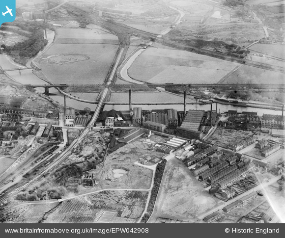
EPW042908 ENGLAND (1933). Mills off Huddersfield Road and environs, Ravensthorpe, 1933
© Copyright OpenStreetMap contributors and licensed by the OpenStreetMap Foundation. 2025. Cartography is licensed as CC BY-SA.
Nearby Images (14)
Details
| Title | [EPW042908] Mills off Huddersfield Road and environs, Ravensthorpe, 1933 |
| Reference | EPW042908 |
| Date | August-1933 |
| Link | |
| Place name | RAVENSTHORPE |
| Parish | |
| District | |
| Country | ENGLAND |
| Easting / Northing | 423097, 420455 |
| Longitude / Latitude | -1.6502840040529, 53.679818152149 |
| National Grid Reference | SE231205 |
Pins
 HOLMES |
Tuesday 22nd of September 2015 10:52:40 AM |


![[EPW042908] Mills off Huddersfield Road and environs, Ravensthorpe, 1933](http://britainfromabove.org.uk/sites/all/libraries/aerofilms-images/public/100x100/EPW/042/EPW042908.jpg)
![[EPW048721] Wharf Mills and Raven Ings Woollen Mills beside the River Calder, Ravensthorpe, 1935](http://britainfromabove.org.uk/sites/all/libraries/aerofilms-images/public/100x100/EPW/048/EPW048721.jpg)
![[EPW042907] Mills off Huddersfield Road and environs, Ravensthorpe, 1933](http://britainfromabove.org.uk/sites/all/libraries/aerofilms-images/public/100x100/EPW/042/EPW042907.jpg)
![[EPW042905] Mills off Huddersfield Road and environs, Ravensthorpe, 1933](http://britainfromabove.org.uk/sites/all/libraries/aerofilms-images/public/100x100/EPW/042/EPW042905.jpg)
![[EPW042904] Mills off Huddersfield Road and environs, Ravensthorpe, 1933](http://britainfromabove.org.uk/sites/all/libraries/aerofilms-images/public/100x100/EPW/042/EPW042904.jpg)
![[EPW048719] Wharf Mills and Raven Ings Woollen Mills beside the River Calder, Ravensthorpe, 1935](http://britainfromabove.org.uk/sites/all/libraries/aerofilms-images/public/100x100/EPW/048/EPW048719.jpg)
![[EPW048722] Wharf Mills and Raven Ings Woollen Mills beside the River Calder, Ravensthorpe, 1935](http://britainfromabove.org.uk/sites/all/libraries/aerofilms-images/public/100x100/EPW/048/EPW048722.jpg)
![[EPW042906] Mills off Huddersfield Road and environs, Ravensthorpe, 1933](http://britainfromabove.org.uk/sites/all/libraries/aerofilms-images/public/100x100/EPW/042/EPW042906.jpg)
![[EPW048718] Wharf Mills and Raven Ings Woollen Mills beside the River Calder, Ravensthorpe, 1935](http://britainfromabove.org.uk/sites/all/libraries/aerofilms-images/public/100x100/EPW/048/EPW048718.jpg)
![[EPW048716] Wharf Mills and Raven Ings Woollen Mills beside the River Calder, Ravensthorpe, 1935. This image has been produced from a copy-negative.](http://britainfromabove.org.uk/sites/all/libraries/aerofilms-images/public/100x100/EPW/048/EPW048716.jpg)
![[EPW048720] Wharf Mills and Raven Ings Woollen Mills beside the River Calder, Ravensthorpe, 1935](http://britainfromabove.org.uk/sites/all/libraries/aerofilms-images/public/100x100/EPW/048/EPW048720.jpg)
![[EPW048715] Wharf Mills and Raven Ings Woollen Mills beside the River Calder, Ravensthorpe, 1935](http://britainfromabove.org.uk/sites/all/libraries/aerofilms-images/public/100x100/EPW/048/EPW048715.jpg)
![[EPW048717] Wharf Mills and Raven Ings Woollen Mills beside the River Calder, Ravensthorpe, 1935](http://britainfromabove.org.uk/sites/all/libraries/aerofilms-images/public/100x100/EPW/048/EPW048717.jpg)
![[EPW048714] Wharf Mills and Raven Ings Woollen Mills beside the River Calder, Ravensthorpe, 1935](http://britainfromabove.org.uk/sites/all/libraries/aerofilms-images/public/100x100/EPW/048/EPW048714.jpg)