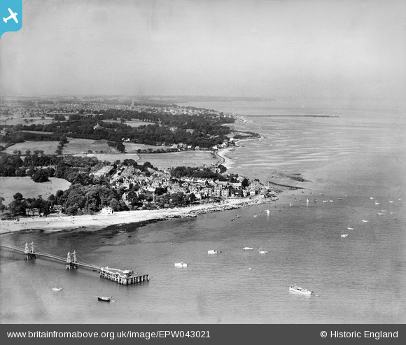
EPW043021 ENGLAND (1933). Nettlestone Point and the coast towards Ryde, Seaview, from the east, 1933
© Copyright OpenStreetMap contributors and licensed by the OpenStreetMap Foundation. 2025. Cartography is licensed as CC BY-SA.
Nearby Images (5)
Details
| Title | [EPW043021] Nettlestone Point and the coast towards Ryde, Seaview, from the east, 1933 |
| Reference | EPW043021 |
| Date | August-1933 |
| Link | |
| Place name | SEAVIEW |
| Parish | NETTLESTONE AND SEAVIEW |
| District | |
| Country | ENGLAND |
| Easting / Northing | 463147, 91553 |
| Longitude / Latitude | -1.1053684408824, 50.719594882725 |
| National Grid Reference | SZ631916 |
Pins
 Charlie Chalk |
Thursday 28th of October 2021 07:06:38 PM | |
 Rob |
Wednesday 30th of July 2014 04:25:49 PM | |
 Maurice |
Thursday 29th of August 2013 06:06:49 PM |


![[EPW043021] Nettlestone Point and the coast towards Ryde, Seaview, from the east, 1933](http://britainfromabove.org.uk/sites/all/libraries/aerofilms-images/public/100x100/EPW/043/EPW043021.jpg)
![[EAW022220] Nettlestone Point and the village, Seaview, from the east, 1949](http://britainfromabove.org.uk/sites/all/libraries/aerofilms-images/public/100x100/EAW/022/EAW022220.jpg)
![[EPW000790] The High Street, Seaview, from the north-east, 1920](http://britainfromabove.org.uk/sites/all/libraries/aerofilms-images/public/100x100/EPW/000/EPW000790.jpg)
![[EPW039636] Nettlestone Point and environs, Seaview, 1932](http://britainfromabove.org.uk/sites/all/libraries/aerofilms-images/public/100x100/EPW/039/EPW039636.jpg)
![[EPW023042] Nettlestone Point and the village, Seaview, 1928. This image has been produced from a copy-negative.](http://britainfromabove.org.uk/sites/all/libraries/aerofilms-images/public/100x100/EPW/023/EPW023042.jpg)

