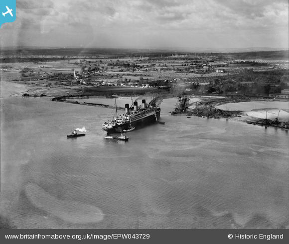
EPW043729 ENGLAND (1934). RMS Majestic entering the King George V Graving Dock, Southampton, 1934
© Copyright OpenStreetMap contributors and licensed by the OpenStreetMap Foundation. 2025. Cartography is licensed as CC BY-SA.
Nearby Images (19)
Details
| Title | [EPW043729] RMS Majestic entering the King George V Graving Dock, Southampton, 1934 |
| Reference | EPW043729 |
| Date | January-1934 |
| Link | |
| Place name | SOUTHAMPTON |
| Parish | |
| District | |
| Country | ENGLAND |
| Easting / Northing | 439415, 112174 |
| Longitude / Latitude | -1.4393522127779, 50.907137250357 |
| National Grid Reference | SU394122 |
Pins
Be the first to add a comment to this image!


![[EPW043729] RMS Majestic entering the King George V Graving Dock, Southampton, 1934](http://britainfromabove.org.uk/sites/all/libraries/aerofilms-images/public/100x100/EPW/043/EPW043729.jpg)
![[EPW043736] RMS Majestic entering the King George V Graving Dock, Southampton, 1934](http://britainfromabove.org.uk/sites/all/libraries/aerofilms-images/public/100x100/EPW/043/EPW043736.jpg)
![[EPW043734] RMS Majestic entering the King George V Graving Dock, Southampton, 1934](http://britainfromabove.org.uk/sites/all/libraries/aerofilms-images/public/100x100/EPW/043/EPW043734.jpg)
![[EPW042951] King George V Graving Dock and environs, Southampton, from the south-east, 1933](http://britainfromabove.org.uk/sites/all/libraries/aerofilms-images/public/100x100/EPW/042/EPW042951.jpg)
![[EPW043727] RMS Majestic entering the King George V Graving Dock, Southampton, 1934](http://britainfromabove.org.uk/sites/all/libraries/aerofilms-images/public/100x100/EPW/043/EPW043727.jpg)
![[EPW043726] RMS Majestic entering the King George V Graving Dock, Southampton, 1934](http://britainfromabove.org.uk/sites/all/libraries/aerofilms-images/public/100x100/EPW/043/EPW043726.jpg)
![[EPW043733] RMS Majestic entering the King George V Graving Dock, Southampton, 1934](http://britainfromabove.org.uk/sites/all/libraries/aerofilms-images/public/100x100/EPW/043/EPW043733.jpg)
![[EPW043735] RMS Majestic entering the King George V Graving Dock, Southampton, 1934](http://britainfromabove.org.uk/sites/all/libraries/aerofilms-images/public/100x100/EPW/043/EPW043735.jpg)
![[EPW043725] RMS Majestic entering the King George V Graving Dock, Southampton, from the south-west, 1934](http://britainfromabove.org.uk/sites/all/libraries/aerofilms-images/public/100x100/EPW/043/EPW043725.jpg)
![[EPW043731] RMS Majestic entering the King George V Graving Dock, Southampton, from the south-east, 1934](http://britainfromabove.org.uk/sites/all/libraries/aerofilms-images/public/100x100/EPW/043/EPW043731.jpg)
![[EPW043728] RMS Majestic entering the King George V Graving Dock, Southampton, from the south-east, 1934](http://britainfromabove.org.uk/sites/all/libraries/aerofilms-images/public/100x100/EPW/043/EPW043728.jpg)
![[EAW001352] The King George V Graving Dock, Southampton, from the south, 1946](http://britainfromabove.org.uk/sites/all/libraries/aerofilms-images/public/100x100/EAW/001/EAW001352.jpg)
![[EAW004210] Queen Mary in dry dock, Southampton, 1947](http://britainfromabove.org.uk/sites/all/libraries/aerofilms-images/public/100x100/EAW/004/EAW004210.jpg)
![[EPW043730] RMS Majestic entering the King George V Graving Dock, Southampton, from the south-west, 1934](http://britainfromabove.org.uk/sites/all/libraries/aerofilms-images/public/100x100/EPW/043/EPW043730.jpg)
![[EAW004211] Queen Mary in dry dock, Southampton, 1947](http://britainfromabove.org.uk/sites/all/libraries/aerofilms-images/public/100x100/EAW/004/EAW004211.jpg)
![[EAW205604] Southampton Docks, Southampton, 1970](http://britainfromabove.org.uk/sites/all/libraries/aerofilms-images/public/100x100/EAW/205/EAW205604.jpg)
![[EPW043732] RMS Majestic entering the King George V Graving Dock, Southampton, from the south-west, 1934](http://britainfromabove.org.uk/sites/all/libraries/aerofilms-images/public/100x100/EPW/043/EPW043732.jpg)
![[EAW001351] The King George V Graving Dock, Southampton, 1946](http://britainfromabove.org.uk/sites/all/libraries/aerofilms-images/public/100x100/EAW/001/EAW001351.jpg)
![[EAW035812] The General Motors Works off West Bay Road and environs, Southampton, 1951. This image has been produced from a print.](http://britainfromabove.org.uk/sites/all/libraries/aerofilms-images/public/100x100/EAW/035/EAW035812.jpg)