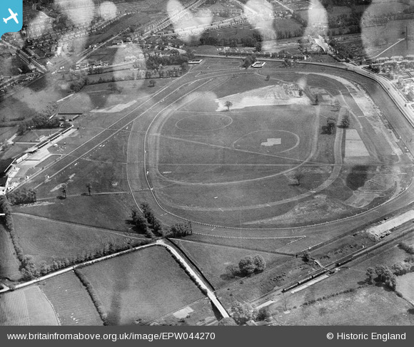
EPW044270 ENGLAND (1934). Northolt Park Racecourse, Northolt, 1934. This image has been produced from a damaged negative.
© Copyright OpenStreetMap contributors and licensed by the OpenStreetMap Foundation. 2025. Cartography is licensed as CC BY-SA.
Nearby Images (19)
Details
| Title | [EPW044270] Northolt Park Racecourse, Northolt, 1934. This image has been produced from a damaged negative. |
| Reference | EPW044270 |
| Date | May-1934 |
| Link | |
| Place name | NORTHOLT |
| Parish | |
| District | |
| Country | ENGLAND |
| Easting / Northing | 513211, 184870 |
| Longitude / Latitude | -0.36699194350503, 51.550868911069 |
| National Grid Reference | TQ132849 |
Pins
Be the first to add a comment to this image!


![[EPW044270] Northolt Park Racecourse, Northolt, 1934. This image has been produced from a damaged negative.](http://britainfromabove.org.uk/sites/all/libraries/aerofilms-images/public/100x100/EPW/044/EPW044270.jpg)
![[EPW040902] Northolt Park Race Course, Northolt, 1933](http://britainfromabove.org.uk/sites/all/libraries/aerofilms-images/public/100x100/EPW/040/EPW040902.jpg)
![[EPR000013] Northolt Park Race Course, Northolt, 1934](http://britainfromabove.org.uk/sites/all/libraries/aerofilms-images/public/100x100/EPR/000/EPR000013.jpg)
![[EPW044271] Northolt Park Racecourse and environs, Northolt, 1934](http://britainfromabove.org.uk/sites/all/libraries/aerofilms-images/public/100x100/EPW/044/EPW044271.jpg)
![[EPW040900] Northolt Park Race Course, Northolt, 1933](http://britainfromabove.org.uk/sites/all/libraries/aerofilms-images/public/100x100/EPW/040/EPW040900.jpg)
![[EPW044273] Northolt Park Racecourse and environs, Northolt, 1934](http://britainfromabove.org.uk/sites/all/libraries/aerofilms-images/public/100x100/EPW/044/EPW044273.jpg)
![[EPR000014] Northolt Park Race Course, Northolt, 1934](http://britainfromabove.org.uk/sites/all/libraries/aerofilms-images/public/100x100/EPR/000/EPR000014.jpg)
![[EPW044554] Northolt Park Race Course, Northolt, 1934](http://britainfromabove.org.uk/sites/all/libraries/aerofilms-images/public/100x100/EPW/044/EPW044554.jpg)
![[EPR000621] Northolt Park Racecourse, Northolt, 1935](http://britainfromabove.org.uk/sites/all/libraries/aerofilms-images/public/100x100/EPR/000/EPR000621.jpg)
![[EPW040901] Northolt Park Race Course, Northolt, 1933](http://britainfromabove.org.uk/sites/all/libraries/aerofilms-images/public/100x100/EPW/040/EPW040901.jpg)
![[EPW040793] Northolt Park Racecourse, Northolt, from the south-west, 1933](http://britainfromabove.org.uk/sites/all/libraries/aerofilms-images/public/100x100/EPW/040/EPW040793.jpg)
![[EPW044947] Northolt, Race Meeting at Northolt Park Racecourse, 1934](http://britainfromabove.org.uk/sites/all/libraries/aerofilms-images/public/100x100/EPW/044/EPW044947.jpg)
![[EPW035054] Northolt Park Race Course, Northolt, 1931](http://britainfromabove.org.uk/sites/all/libraries/aerofilms-images/public/100x100/EPW/035/EPW035054.jpg)
![[EPW044950] Northolt, Race Meeting at Northolt Park Racecourse, 1934](http://britainfromabove.org.uk/sites/all/libraries/aerofilms-images/public/100x100/EPW/044/EPW044950.jpg)
![[EPW044269] The stands and paddock at Northolt Park Racecourse, Northolt, 1934. This image has been produced from a damaged negative.](http://britainfromabove.org.uk/sites/all/libraries/aerofilms-images/public/100x100/EPW/044/EPW044269.jpg)
![[EPW040795] Northolt Park Racecourse, Northolt, from the south-west, 1933](http://britainfromabove.org.uk/sites/all/libraries/aerofilms-images/public/100x100/EPW/040/EPW040795.jpg)
![[EPW040797] Northolt Park Racecourse, Northolt, from the south-west, 1933](http://britainfromabove.org.uk/sites/all/libraries/aerofilms-images/public/100x100/EPW/040/EPW040797.jpg)
![[EPW044272] Northolt Park Racecourse and environs, Northolt, 1934](http://britainfromabove.org.uk/sites/all/libraries/aerofilms-images/public/100x100/EPW/044/EPW044272.jpg)
![[EPW040794] Northolt Park Racecourse, Northolt, from the south-west, 1933](http://britainfromabove.org.uk/sites/all/libraries/aerofilms-images/public/100x100/EPW/040/EPW040794.jpg)