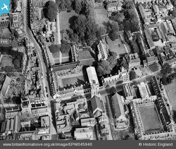
EPW045940 ENGLAND (1934). Pembroke College, Cambridge, 1934
© Copyright OpenStreetMap contributors and licensed by the OpenStreetMap Foundation. 2025. Cartography is licensed as CC BY-SA.
Nearby Images (36)
Details
| Title | [EPW045940] Pembroke College, Cambridge, 1934 |
| Reference | EPW045940 |
| Date | August-1934 |
| Link | |
| Place name | CAMBRIDGE |
| Parish | |
| District | |
| Country | ENGLAND |
| Easting / Northing | 544898, 258040 |
| Longitude / Latitude | 0.12049885593096, 52.201116232229 |
| National Grid Reference | TL449580 |
Pins
Be the first to add a comment to this image!


![[EPW045940] Pembroke College, Cambridge, 1934](http://britainfromabove.org.uk/sites/all/libraries/aerofilms-images/public/100x100/EPW/045/EPW045940.jpg)
![[EPW045941] Cambridge Colleges, Cambridge, 1934](http://britainfromabove.org.uk/sites/all/libraries/aerofilms-images/public/100x100/EPW/045/EPW045941.jpg)
![[EPW045939] Pembroke College, Cambridge, 1934](http://britainfromabove.org.uk/sites/all/libraries/aerofilms-images/public/100x100/EPW/045/EPW045939.jpg)
![[EPW045938] Pembroke College, Cambridge, 1934](http://britainfromabove.org.uk/sites/all/libraries/aerofilms-images/public/100x100/EPW/045/EPW045938.jpg)
![[EPW000059] The Pitt Press, Cambridge, 1920](http://britainfromabove.org.uk/sites/all/libraries/aerofilms-images/public/100x100/EPW/000/EPW000059.jpg)
![[EPW045942] Cambridge Colleges, Cambridge, 1934](http://britainfromabove.org.uk/sites/all/libraries/aerofilms-images/public/100x100/EPW/045/EPW045942.jpg)
![[EAW002919] Peterhouse, St Catharine's College and Kings College, Cambridge, 1946](http://britainfromabove.org.uk/sites/all/libraries/aerofilms-images/public/100x100/EAW/002/EAW002919.jpg)
![[EAW014114] Clare College, King's College and Queens' College, Cambridge, 1948](http://britainfromabove.org.uk/sites/all/libraries/aerofilms-images/public/100x100/EAW/014/EAW014114.jpg)
![[EPW000047] Corpus Christi College and environs, Cambridge, 1920](http://britainfromabove.org.uk/sites/all/libraries/aerofilms-images/public/100x100/EPW/000/EPW000047.jpg)
![[EPW009785] The Downing Site, Cambridge, 1924](http://britainfromabove.org.uk/sites/all/libraries/aerofilms-images/public/100x100/EPW/009/EPW009785.jpg)
![[EPW009788] The Fitzwilliam Museum, Cambridge, 1924](http://britainfromabove.org.uk/sites/all/libraries/aerofilms-images/public/100x100/EPW/009/EPW009788.jpg)
![[EPW000055] The Fitzwilliam Museum, Cambridge, 1920](http://britainfromabove.org.uk/sites/all/libraries/aerofilms-images/public/100x100/EPW/000/EPW000055.jpg)
![[EPW009773] The Downing Site, Cambridge, 1924](http://britainfromabove.org.uk/sites/all/libraries/aerofilms-images/public/100x100/EPW/009/EPW009773.jpg)
![[EPW009775] The Fitzwilliam Museum, Cambridge, 1924](http://britainfromabove.org.uk/sites/all/libraries/aerofilms-images/public/100x100/EPW/009/EPW009775.jpg)
![[EAW012473] St Catharine's College and environs, Cambridge, 1947](http://britainfromabove.org.uk/sites/all/libraries/aerofilms-images/public/100x100/EAW/012/EAW012473.jpg)
![[EAW012472] Colleges on The Backs and environs, Cambridge, from the south, 1947](http://britainfromabove.org.uk/sites/all/libraries/aerofilms-images/public/100x100/EAW/012/EAW012472.jpg)
![[EAW002920] Trumpington Street and the city centre, Cambridge, from the south-east, 1946](http://britainfromabove.org.uk/sites/all/libraries/aerofilms-images/public/100x100/EAW/002/EAW002920.jpg)
![[EAW012467] Colleges on The Backs, Cambridge, from the south, 1947](http://britainfromabove.org.uk/sites/all/libraries/aerofilms-images/public/100x100/EAW/012/EAW012467.jpg)
![[EPW025464] University buildings off Downing Street, Cambridge, 1928. This image has been produced from a copy-negative.](http://britainfromabove.org.uk/sites/all/libraries/aerofilms-images/public/100x100/EPW/025/EPW025464.jpg)
![[EPW009784] Colleges on The Backs, Cambridge, 1924](http://britainfromabove.org.uk/sites/all/libraries/aerofilms-images/public/100x100/EPW/009/EPW009784.jpg)
![[EAW012474] Queen's College Chapel, the President's Garden and environs, Cambridge, 1947](http://britainfromabove.org.uk/sites/all/libraries/aerofilms-images/public/100x100/EAW/012/EAW012474.jpg)
![[EPW000043] The Downing Site, Cambridge, 1920](http://britainfromabove.org.uk/sites/all/libraries/aerofilms-images/public/100x100/EPW/000/EPW000043.jpg)
![[EPW000039] The Downing Site, Cambridge, 1920](http://britainfromabove.org.uk/sites/all/libraries/aerofilms-images/public/100x100/EPW/000/EPW000039.jpg)
![[EAW012471] St Catharine's College and environs, Cambridge, 1947](http://britainfromabove.org.uk/sites/all/libraries/aerofilms-images/public/100x100/EAW/012/EAW012471.jpg)
![[EAW012477] Queen's College Chapel and environs, Cambridge, 1947](http://britainfromabove.org.uk/sites/all/libraries/aerofilms-images/public/100x100/EAW/012/EAW012477.jpg)
![[EAW012476] Queen's College and environs, Cambridge, 1947](http://britainfromabove.org.uk/sites/all/libraries/aerofilms-images/public/100x100/EAW/012/EAW012476.jpg)
![[EAW012478] Queen's College and environs, Cambridge, 1947](http://britainfromabove.org.uk/sites/all/libraries/aerofilms-images/public/100x100/EAW/012/EAW012478.jpg)
![[EPW009780] The Downing Site, Cambridge, 1924](http://britainfromabove.org.uk/sites/all/libraries/aerofilms-images/public/100x100/EPW/009/EPW009780.jpg)
![[EAW012475] Queen's College Chapel and Friar's Court, Cambridge, 1947](http://britainfromabove.org.uk/sites/all/libraries/aerofilms-images/public/100x100/EAW/012/EAW012475.jpg)
![[EPW009781] Colleges on The Backs, Cambridge, 1924](http://britainfromabove.org.uk/sites/all/libraries/aerofilms-images/public/100x100/EPW/009/EPW009781.jpg)
![[EAW012463] Colleges on The Backs and the city, Cambridge, 1947](http://britainfromabove.org.uk/sites/all/libraries/aerofilms-images/public/100x100/EAW/012/EAW012463.jpg)
![[EAW012462] Colleges on The Backs, Cambridge, 1947](http://britainfromabove.org.uk/sites/all/libraries/aerofilms-images/public/100x100/EAW/012/EAW012462.jpg)
![[EAW002918] St Catharine's College, Kings College Chapel and Trinity College, Cambridge, 1946](http://britainfromabove.org.uk/sites/all/libraries/aerofilms-images/public/100x100/EAW/002/EAW002918.jpg)
![[EAW004874] The city centre, Cambridge, from the south-west, 1947](http://britainfromabove.org.uk/sites/all/libraries/aerofilms-images/public/100x100/EAW/004/EAW004874.jpg)
![[EPW059040] Trumpington Street, Addenbrooke's Hospital and environs, Cambridge, 1938. This image has been produced from a copy-negative.](http://britainfromabove.org.uk/sites/all/libraries/aerofilms-images/public/100x100/EPW/059/EPW059040.jpg)
![[EAW012469] Bodley's Court, Cambridge, 1947](http://britainfromabove.org.uk/sites/all/libraries/aerofilms-images/public/100x100/EAW/012/EAW012469.jpg)