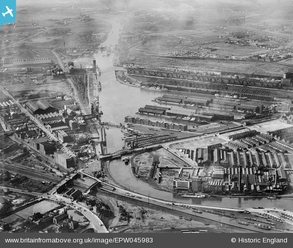
EPW045983 ENGLAND (1934). Salford Docks, Salford, from the south-east, 1934
© Copyright OpenStreetMap contributors and licensed by the OpenStreetMap Foundation. 2025. Cartography is licensed as CC BY-SA.
Nearby Images (11)
Details
| Title | [EPW045983] Salford Docks, Salford, from the south-east, 1934 |
| Reference | EPW045983 |
| Date | September-1934 |
| Link | |
| Place name | SALFORD |
| Parish | |
| District | |
| Country | ENGLAND |
| Easting / Northing | 381327, 396586 |
| Longitude / Latitude | -2.2813046993074, 53.465430753102 |
| National Grid Reference | SJ813966 |
Pins
 Barrie Price |
Thursday 15th of July 2021 12:39:41 PM | |
 phloberts |
Sunday 20th of January 2019 10:31:20 PM |


![[EPW045983] Salford Docks, Salford, from the south-east, 1934](http://britainfromabove.org.uk/sites/all/libraries/aerofilms-images/public/100x100/EPW/045/EPW045983.jpg)
![[EPW045066] The Trafford Road Bridge and industrial works alongside the Pomona Docks, Ordsall, 1934](http://britainfromabove.org.uk/sites/all/libraries/aerofilms-images/public/100x100/EPW/045/EPW045066.jpg)
![[EPW045071] Industrial works alongside the Manchester Ship Canal, Ordsall, 1934](http://britainfromabove.org.uk/sites/all/libraries/aerofilms-images/public/100x100/EPW/045/EPW045071.jpg)
![[EPW045992] Pomona Docks, Salford, from the west, 1934](http://britainfromabove.org.uk/sites/all/libraries/aerofilms-images/public/100x100/EPW/045/EPW045992.jpg)
![[EPW045070] Industrial works alongside the Manchester Ship Canal, Ordsall, 1934](http://britainfromabove.org.uk/sites/all/libraries/aerofilms-images/public/100x100/EPW/045/EPW045070.jpg)
![[EPW045065] The Trafford Road Bridge and industrial works alongside the Pomona Docks, Ordsall, 1934](http://britainfromabove.org.uk/sites/all/libraries/aerofilms-images/public/100x100/EPW/045/EPW045065.jpg)
![[EPW045069] The Trafford Road Bridge and industrial works alongside the Pomona Docks, Ordsall, 1934](http://britainfromabove.org.uk/sites/all/libraries/aerofilms-images/public/100x100/EPW/045/EPW045069.jpg)
![[EPW045067] The Ivy Soap Works, the English and Scottish Joint Co-operative Wholesale Society Works and the Old Trafford Greyhound Racing Track, Ordsall, 1934](http://britainfromabove.org.uk/sites/all/libraries/aerofilms-images/public/100x100/EPW/045/EPW045067.jpg)
![[EPW016773] Goodwin's Ivy Soap Works and environs, Ordsall, 1926](http://britainfromabove.org.uk/sites/all/libraries/aerofilms-images/public/100x100/EPW/016/EPW016773.jpg)
![[EPW016772] Goodwin's Ivy Soap Works and environs, Ordsall, 1926](http://britainfromabove.org.uk/sites/all/libraries/aerofilms-images/public/100x100/EPW/016/EPW016772.jpg)
![[EPW016777] Goodwin's Ivy Soap Works and Pomona Docks, Ordsall, 1926](http://britainfromabove.org.uk/sites/all/libraries/aerofilms-images/public/100x100/EPW/016/EPW016777.jpg)