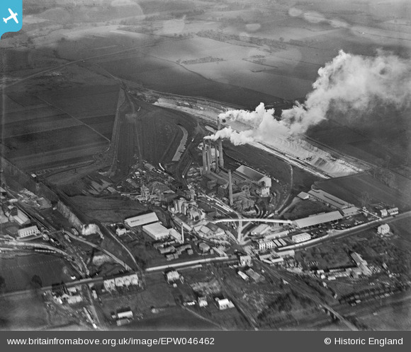
EPW046462 ENGLAND (1935). The Tunnel Portland Cement Works, West Thurrock, 1935
© Copyright OpenStreetMap contributors and licensed by the OpenStreetMap Foundation. 2025. Cartography is licensed as CC BY-SA.
Nearby Images (35)
Details
| Title | [EPW046462] The Tunnel Portland Cement Works, West Thurrock, 1935 |
| Reference | EPW046462 |
| Date | January-1935 |
| Link | |
| Place name | WEST THURROCK |
| Parish | |
| District | |
| Country | ENGLAND |
| Easting / Northing | 557680, 177986 |
| Longitude / Latitude | 0.27090369919606, 51.47833840917 |
| National Grid Reference | TQ577780 |
Pins
Be the first to add a comment to this image!


![[EPW046462] The Tunnel Portland Cement Works, West Thurrock, 1935](http://britainfromabove.org.uk/sites/all/libraries/aerofilms-images/public/100x100/EPW/046/EPW046462.jpg)
![[EPW039470] The Tunnel Cement Works, West Thurrock, 1932](http://britainfromabove.org.uk/sites/all/libraries/aerofilms-images/public/100x100/EPW/039/EPW039470.jpg)
![[EPW057047] The Tunnel Portland Cement Works, West Thurrock, 1938](http://britainfromabove.org.uk/sites/all/libraries/aerofilms-images/public/100x100/EPW/057/EPW057047.jpg)
![[EPW046466] The Tunnel Portland Cement Works, West Thurrock, 1935](http://britainfromabove.org.uk/sites/all/libraries/aerofilms-images/public/100x100/EPW/046/EPW046466.jpg)
![[EPW057044] The Tunnel Portland Cement Works, West Thurrock, 1938](http://britainfromabove.org.uk/sites/all/libraries/aerofilms-images/public/100x100/EPW/057/EPW057044.jpg)
![[EPW046467] The Tunnel Portland Cement Works, West Thurrock, 1935](http://britainfromabove.org.uk/sites/all/libraries/aerofilms-images/public/100x100/EPW/046/EPW046467.jpg)
![[EPW032826] The Fondu Aluminous Cement Works and environs, West Thurrock, 1930](http://britainfromabove.org.uk/sites/all/libraries/aerofilms-images/public/100x100/EPW/032/EPW032826.jpg)
![[EPW046468] The Tunnel Portland Cement Works, West Thurrock, 1935](http://britainfromabove.org.uk/sites/all/libraries/aerofilms-images/public/100x100/EPW/046/EPW046468.jpg)
![[EPW026639] The Tunnel Portland Cement Works, West Thurrock, 1929](http://britainfromabove.org.uk/sites/all/libraries/aerofilms-images/public/100x100/EPW/026/EPW026639.jpg)
![[EPW039473] The Tunnel Cement Works, West Thurrock, 1932](http://britainfromabove.org.uk/sites/all/libraries/aerofilms-images/public/100x100/EPW/039/EPW039473.jpg)
![[EPW026640] The Tunnel Portland Cement Works, West Thurrock, 1929](http://britainfromabove.org.uk/sites/all/libraries/aerofilms-images/public/100x100/EPW/026/EPW026640.jpg)
![[EPW057052] The Tunnel Portland Cement Works, West Thurrock, 1938](http://britainfromabove.org.uk/sites/all/libraries/aerofilms-images/public/100x100/EPW/057/EPW057052.jpg)
![[EPW057050] The Tunnel Portland Cement Works, West Thurrock, 1938](http://britainfromabove.org.uk/sites/all/libraries/aerofilms-images/public/100x100/EPW/057/EPW057050.jpg)
![[EPW039471] The Tunnel Cement Works, West Thurrock, 1932](http://britainfromabove.org.uk/sites/all/libraries/aerofilms-images/public/100x100/EPW/039/EPW039471.jpg)
![[EPW026644] The Tunnel Portland Cement Works, West Thurrock, 1929](http://britainfromabove.org.uk/sites/all/libraries/aerofilms-images/public/100x100/EPW/026/EPW026644.jpg)
![[EPW057054] The Tunnel Portland Cement Works, West Thurrock, 1938](http://britainfromabove.org.uk/sites/all/libraries/aerofilms-images/public/100x100/EPW/057/EPW057054.jpg)
![[EPW057046] The Tunnel Portland Cement Works, West Thurrock, 1938](http://britainfromabove.org.uk/sites/all/libraries/aerofilms-images/public/100x100/EPW/057/EPW057046.jpg)
![[EPW057043] The Tunnel Portland Cement Works, West Thurrock, 1938](http://britainfromabove.org.uk/sites/all/libraries/aerofilms-images/public/100x100/EPW/057/EPW057043.jpg)
![[EPW032825] The Fondu Aluminous Cement Works, West Thurrock, 1930](http://britainfromabove.org.uk/sites/all/libraries/aerofilms-images/public/100x100/EPW/032/EPW032825.jpg)
![[EPW057053] The Tunnel Portland Cement Works, West Thurrock, 1938](http://britainfromabove.org.uk/sites/all/libraries/aerofilms-images/public/100x100/EPW/057/EPW057053.jpg)
![[EPW057055] The Tunnel Portland Cement Works, West Thurrock, 1938](http://britainfromabove.org.uk/sites/all/libraries/aerofilms-images/public/100x100/EPW/057/EPW057055.jpg)
![[EPW039476] The Tunnel Cement Works and the Thurrock Chalk Quarries, West Thurrock, 1932](http://britainfromabove.org.uk/sites/all/libraries/aerofilms-images/public/100x100/EPW/039/EPW039476.jpg)
![[EPW039475] The Tunnel Cement Works and the Thurrock Chalk Quarries, West Thurrock, 1932](http://britainfromabove.org.uk/sites/all/libraries/aerofilms-images/public/100x100/EPW/039/EPW039475.jpg)
![[EPW057048] The Tunnel Portland Cement Works, West Thurrock, 1938](http://britainfromabove.org.uk/sites/all/libraries/aerofilms-images/public/100x100/EPW/057/EPW057048.jpg)
![[EPW039474] The Tunnel Cement Works, West Thurrock, 1932](http://britainfromabove.org.uk/sites/all/libraries/aerofilms-images/public/100x100/EPW/039/EPW039474.jpg)
![[EPW046464] The Tunnel Portland Cement Works, West Thurrock, 1935](http://britainfromabove.org.uk/sites/all/libraries/aerofilms-images/public/100x100/EPW/046/EPW046464.jpg)
![[EPW046469] The Tunnel Portland Cement Works, West Thurrock, 1935](http://britainfromabove.org.uk/sites/all/libraries/aerofilms-images/public/100x100/EPW/046/EPW046469.jpg)
![[EPW046463] The Tunnel Portland Cement Works, West Thurrock, 1935](http://britainfromabove.org.uk/sites/all/libraries/aerofilms-images/public/100x100/EPW/046/EPW046463.jpg)
![[EPW046470] The Tunnel Portland Cement Works, West Thurrock, 1935](http://britainfromabove.org.uk/sites/all/libraries/aerofilms-images/public/100x100/EPW/046/EPW046470.jpg)
![[EPW057049] The Tunnel Portland Cement Works, West Thurrock, 1938](http://britainfromabove.org.uk/sites/all/libraries/aerofilms-images/public/100x100/EPW/057/EPW057049.jpg)
![[EPW039472] The Tunnel Cement Works and the Thurrock Chalk Quarries, West Thurrock, 1932](http://britainfromabove.org.uk/sites/all/libraries/aerofilms-images/public/100x100/EPW/039/EPW039472.jpg)
![[EPW057051] The Tunnel Portland Cement Works, West Thurrock, from the south-west, 1938](http://britainfromabove.org.uk/sites/all/libraries/aerofilms-images/public/100x100/EPW/057/EPW057051.jpg)
![[EPW046465] The Tunnel Portland Cement Works, West Thurrock, 1935](http://britainfromabove.org.uk/sites/all/libraries/aerofilms-images/public/100x100/EPW/046/EPW046465.jpg)
![[EPW057045] The Tunnel Portland Cement Works, West Thurrock, 1938](http://britainfromabove.org.uk/sites/all/libraries/aerofilms-images/public/100x100/EPW/057/EPW057045.jpg)
![[EAW002393] The Lafarge Aluminous Cement Co. Fondu Works and environs, West Thurrock, from the south-west, 1946](http://britainfromabove.org.uk/sites/all/libraries/aerofilms-images/public/100x100/EAW/002/EAW002393.jpg)