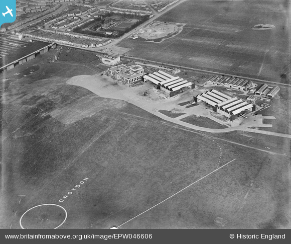
EPW046606 ENGLAND (1935). Croydon Airport, Croydon, 1935
© Copyright OpenStreetMap contributors and licensed by the OpenStreetMap Foundation. 2025. Cartography is licensed as CC BY-SA.
Nearby Images (29)
Details
| Title | [EPW046606] Croydon Airport, Croydon, 1935 |
| Reference | EPW046606 |
| Date | March-1935 |
| Link | |
| Place name | CROYDON |
| Parish | |
| District | |
| Country | ENGLAND |
| Easting / Northing | 531055, 163443 |
| Longitude / Latitude | -0.11768100113717, 51.354426273508 |
| National Grid Reference | TQ311634 |
Pins
 JohnM |
Sunday 17th of July 2016 11:23:06 AM |


![[EPW046606] Croydon Airport, Croydon, 1935](http://britainfromabove.org.uk/sites/all/libraries/aerofilms-images/public/100x100/EPW/046/EPW046606.jpg)
![[EPW046609] Croydon Airport, Croydon, 1935](http://britainfromabove.org.uk/sites/all/libraries/aerofilms-images/public/100x100/EPW/046/EPW046609.jpg)
![[EPW046607] Croydon Airport, Croydon, 1935](http://britainfromabove.org.uk/sites/all/libraries/aerofilms-images/public/100x100/EPW/046/EPW046607.jpg)
![[EPW060370] Terminal building, hotel and hangars at Croydon Airport, Croydon, 1939](http://britainfromabove.org.uk/sites/all/libraries/aerofilms-images/public/100x100/EPW/060/EPW060370.jpg)
![[EPW032785] Croydon Airport, Croydon, from the west, 1930](http://britainfromabove.org.uk/sites/all/libraries/aerofilms-images/public/100x100/EPW/032/EPW032785.jpg)
![[EPW046610] Croydon Airport, Croydon, 1935](http://britainfromabove.org.uk/sites/all/libraries/aerofilms-images/public/100x100/EPW/046/EPW046610.jpg)
![[EPW037828] Hotel, terminal building and hangars at Croydon Airport, Waddon, 1932](http://britainfromabove.org.uk/sites/all/libraries/aerofilms-images/public/100x100/EPW/037/EPW037828.jpg)
![[EPW046608] Croydon Airport, Croydon, 1935](http://britainfromabove.org.uk/sites/all/libraries/aerofilms-images/public/100x100/EPW/046/EPW046608.jpg)
![[EPW046611] Croydon Airport, Croydon, 1935](http://britainfromabove.org.uk/sites/all/libraries/aerofilms-images/public/100x100/EPW/046/EPW046611.jpg)
![[EPW037825] Terminal building and hangars at Croydon Airport, Waddon, 1932](http://britainfromabove.org.uk/sites/all/libraries/aerofilms-images/public/100x100/EPW/037/EPW037825.jpg)
![[EPW021423] Croydon Aerodrome, Croydon, 1928](http://britainfromabove.org.uk/sites/all/libraries/aerofilms-images/public/100x100/EPW/021/EPW021423.jpg)
![[EPW021422] Croydon Aerodrome, Croydon, 1928](http://britainfromabove.org.uk/sites/all/libraries/aerofilms-images/public/100x100/EPW/021/EPW021422.jpg)
![[EAW052826] Rollason's premises at Croydon Airport, Croydon, 1953. This image was marked by Aerofilms Ltd for photo editing.](http://britainfromabove.org.uk/sites/all/libraries/aerofilms-images/public/100x100/EAW/052/EAW052826.jpg)
![[EPW032786] Croydon Airport, Croydon, from the north-west, 1930](http://britainfromabove.org.uk/sites/all/libraries/aerofilms-images/public/100x100/EPW/032/EPW032786.jpg)
![[EAW052827] The Briggs Motor Bodies Ltd Works (Ford Motor Co) at Croydon Airport, Croydon, 1953. This image was marked by Aerofilms Ltd for photo editing.](http://britainfromabove.org.uk/sites/all/libraries/aerofilms-images/public/100x100/EAW/052/EAW052827.jpg)
![[EAW052825] Rollason's premises at Croydon Airport, Croydon, 1953. This image was marked by Aerofilms Ltd for photo editing.](http://britainfromabove.org.uk/sites/all/libraries/aerofilms-images/public/100x100/EAW/052/EAW052825.jpg)
![[EPW025102] Croydon Aerodrome, Croydon, 1928](http://britainfromabove.org.uk/sites/all/libraries/aerofilms-images/public/100x100/EPW/025/EPW025102.jpg)
![[EPW025097] Croydon Aerodrome, Croydon, 1928](http://britainfromabove.org.uk/sites/all/libraries/aerofilms-images/public/100x100/EPW/025/EPW025097.jpg)
![[EPW060397] Croydon Aerodrome and Purley Way Playing Fields, South Croydon, 1939](http://britainfromabove.org.uk/sites/all/libraries/aerofilms-images/public/100x100/EPW/060/EPW060397.jpg)
![[EAW052830] The Briggs Motor Bodies Ltd Works (Ford Motor Co) at Croydon Airport, Croydon, 1953. This image was marked by Aerofilms Ltd for photo editing.](http://britainfromabove.org.uk/sites/all/libraries/aerofilms-images/public/100x100/EAW/052/EAW052830.jpg)
![[EPW037827] Hotel, terminal building and hangars at Croydon Airport, Waddon, 1932](http://britainfromabove.org.uk/sites/all/libraries/aerofilms-images/public/100x100/EPW/037/EPW037827.jpg)
![[EAW052829] The Briggs Motor Bodies Ltd Works (Ford Motor Co) at Croydon Airport, Croydon, 1953. This image was marked by Aerofilms Ltd for photo editing.](http://britainfromabove.org.uk/sites/all/libraries/aerofilms-images/public/100x100/EAW/052/EAW052829.jpg)
![[EPW025098] The Terminal Building at Croydon Aerodrome, Croydon, 1928. This image has been produced from a damaged print.](http://britainfromabove.org.uk/sites/all/libraries/aerofilms-images/public/100x100/EPW/025/EPW025098.jpg)
![[EAW052831] The Briggs Motor Bodies Ltd Works (Ford Motor Co) at Croydon Airport, Croydon, 1953. This image was marked by Aerofilms Ltd for photo editing.](http://britainfromabove.org.uk/sites/all/libraries/aerofilms-images/public/100x100/EAW/052/EAW052831.jpg)
![[EPW025099] The Terminal Building at Croydon Aerodrome, Croydon, 1928. This image has been produced from a copy-negative.](http://britainfromabove.org.uk/sites/all/libraries/aerofilms-images/public/100x100/EPW/025/EPW025099.jpg)
![[EPW037830] Croydon Airport, South Beddington, 1932](http://britainfromabove.org.uk/sites/all/libraries/aerofilms-images/public/100x100/EPW/037/EPW037830.jpg)
![[EAW052828] The Briggs Motor Bodies Ltd Works (Ford Motor Co) at Croydon Airport, Croydon, 1953. This image was marked by Aerofilms Ltd for photo editing.](http://britainfromabove.org.uk/sites/all/libraries/aerofilms-images/public/100x100/EAW/052/EAW052828.jpg)
![[EPW037826] Terminal building and hangars at Croydon Airport, Waddon, 1932](http://britainfromabove.org.uk/sites/all/libraries/aerofilms-images/public/100x100/EPW/037/EPW037826.jpg)
![[EAW052824] Rollason's premises at Croydon Airport and Purley Way Playing Fields, Croydon, 1953. This image was marked by Aerofilms Ltd for photo editing.](http://britainfromabove.org.uk/sites/all/libraries/aerofilms-images/public/100x100/EAW/052/EAW052824.jpg)