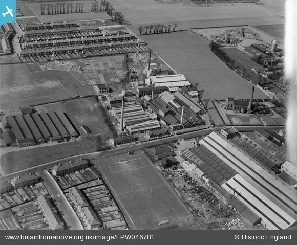
EPW046781 ENGLAND (1935). The Ship Carbon Co Works, Little Heath, 1935
© Copyright OpenStreetMap contributors and licensed by the OpenStreetMap Foundation. 2025. Cartography is licensed as CC BY-SA.
Nearby Images (20)
Details
| Title | [EPW046781] The Ship Carbon Co Works, Little Heath, 1935 |
| Reference | EPW046781 |
| Date | April-1935 |
| Link | |
| Place name | LITTLE HEATH |
| Parish | |
| District | |
| Country | ENGLAND |
| Easting / Northing | 547000, 188272 |
| Longitude / Latitude | 0.12150101491707, 51.573648273982 |
| National Grid Reference | TQ470883 |
Pins
Be the first to add a comment to this image!


![[EPW046781] The Ship Carbon Co Works, Little Heath, 1935](http://britainfromabove.org.uk/sites/all/libraries/aerofilms-images/public/100x100/EPW/046/EPW046781.jpg)
![[EPW046779] The Ship Carbon Co Works and the Ilford Isolation Hospital, Little Heath, 1935](http://britainfromabove.org.uk/sites/all/libraries/aerofilms-images/public/100x100/EPW/046/EPW046779.jpg)
![[EPW046778] The Ship Carbon Co Works, Little Heath, 1935](http://britainfromabove.org.uk/sites/all/libraries/aerofilms-images/public/100x100/EPW/046/EPW046778.jpg)
![[EPW046780] The Ship Carbon Co Works and the Ilford Isolation Hospital, Little Heath, 1935](http://britainfromabove.org.uk/sites/all/libraries/aerofilms-images/public/100x100/EPW/046/EPW046780.jpg)
![[EPW046777] The Ship Carbon Co Works, Little Heath, 1935](http://britainfromabove.org.uk/sites/all/libraries/aerofilms-images/public/100x100/EPW/046/EPW046777.jpg)
![[EPW046783] The Ship Carbon Co Works and the Ilford Isolation Hospital, Little Heath, 1935](http://britainfromabove.org.uk/sites/all/libraries/aerofilms-images/public/100x100/EPW/046/EPW046783.jpg)
![[EAW020751] Stationery Works on Grove Road, Little Heath, 1949. This image was marked by Aerofilms Ltd for photo editing.](http://britainfromabove.org.uk/sites/all/libraries/aerofilms-images/public/100x100/EAW/020/EAW020751.jpg)
![[EAW020752] Stationery Works on Grove Road, Little Heath, 1949](http://britainfromabove.org.uk/sites/all/libraries/aerofilms-images/public/100x100/EAW/020/EAW020752.jpg)
![[EAW020749] Stationery Works on Grove Road and environs, Little Heath, 1949. This image was marked by Aerofilms Ltd for photo editing.](http://britainfromabove.org.uk/sites/all/libraries/aerofilms-images/public/100x100/EAW/020/EAW020749.jpg)
![[EPW046782] The Ship Carbon Co Works and surroundings, Little Heath, 1935](http://britainfromabove.org.uk/sites/all/libraries/aerofilms-images/public/100x100/EPW/046/EPW046782.jpg)
![[EAW020748] Stationery Works on Grove Road, Little Heath, 1949. This image was marked by Aerofilms Ltd for photo editing.](http://britainfromabove.org.uk/sites/all/libraries/aerofilms-images/public/100x100/EAW/020/EAW020748.jpg)
![[EAW020743] Stationery Works on Grove Road, Little Heath, 1949. This image was marked by Aerofilms Ltd for photo editing.](http://britainfromabove.org.uk/sites/all/libraries/aerofilms-images/public/100x100/EAW/020/EAW020743.jpg)
![[EAW020744] Stationery Works on Grove Road, Little Heath, from the south-east, 1949. This image was marked by Aerofilms Ltd for photo editing.](http://britainfromabove.org.uk/sites/all/libraries/aerofilms-images/public/100x100/EAW/020/EAW020744.jpg)
![[EAW020747] Stationery Works on Grove Road, Little Heath, 1949. This image was marked by Aerofilms Ltd for photo editing.](http://britainfromabove.org.uk/sites/all/libraries/aerofilms-images/public/100x100/EAW/020/EAW020747.jpg)
![[EAW020750] Stationery Works on Grove Road, Little Heath, 1949. This image was marked by Aerofilms Ltd for photo editing.](http://britainfromabove.org.uk/sites/all/libraries/aerofilms-images/public/100x100/EAW/020/EAW020750.jpg)
![[EAW020746] Stationery Works on Grove Road, Little Heath, 1949. This image was marked by Aerofilms Ltd for photo editing.](http://britainfromabove.org.uk/sites/all/libraries/aerofilms-images/public/100x100/EAW/020/EAW020746.jpg)
![[EAW020745] Stationery Works on Grove Road, Little Heath, from the east, 1949. This image was marked by Aerofilms Ltd for photo editing.](http://britainfromabove.org.uk/sites/all/libraries/aerofilms-images/public/100x100/EAW/020/EAW020745.jpg)
![[EPW046786] The Ship Carbon Co Works, the Woodland Accumulator Works and Goodmayes Hospital, Little Heath, 1935](http://britainfromabove.org.uk/sites/all/libraries/aerofilms-images/public/100x100/EPW/046/EPW046786.jpg)
![[EPW046787] The Ship Carbon Co Works, Ilford Isolation Hospital and Goodmayes Hospital, Little Heath, 1935](http://britainfromabove.org.uk/sites/all/libraries/aerofilms-images/public/100x100/EPW/046/EPW046787.jpg)
![[EPW046792] The Ship Carbon Co Works, Goodmayes Hospital and the surrounding area, Little Heath, 1935](http://britainfromabove.org.uk/sites/all/libraries/aerofilms-images/public/100x100/EPW/046/EPW046792.jpg)