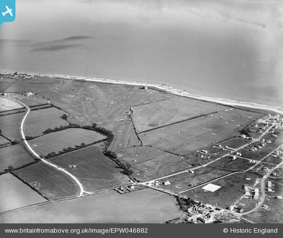
EPW046882 ENGLAND (1935). The Clacton-on-Sea Golf Course, West Road and the seafront, Clacton-on-Sea, 1935
© Copyright OpenStreetMap contributors and licensed by the OpenStreetMap Foundation. 2025. Cartography is licensed as CC BY-SA.
Nearby Images (7)
Details
| Title | [EPW046882] The Clacton-on-Sea Golf Course, West Road and the seafront, Clacton-on-Sea, 1935 |
| Reference | EPW046882 |
| Date | April-1935 |
| Link | |
| Place name | CLACTON-ON-SEA |
| Parish | |
| District | |
| Country | ENGLAND |
| Easting / Northing | 615857, 213511 |
| Longitude / Latitude | 1.1295056872185, 51.778115040063 |
| National Grid Reference | TM159135 |
Pins
 Amiguru |
Wednesday 10th of September 2014 09:44:52 PM | |
 Amiguru |
Wednesday 10th of September 2014 09:44:04 PM | |
 Amiguru |
Wednesday 10th of September 2014 09:43:19 PM | |
 Amiguru |
Wednesday 10th of September 2014 09:42:29 PM | |
 Amiguru |
Wednesday 10th of September 2014 09:41:29 PM | |
 Amiguru |
Wednesday 10th of September 2014 09:40:48 PM | |
 Amiguru |
Wednesday 10th of September 2014 09:39:52 PM | |
 Amiguru |
Wednesday 10th of September 2014 09:38:41 PM | |
 Amiguru |
Wednesday 10th of September 2014 09:38:02 PM | |
 Amiguru |
Wednesday 10th of September 2014 09:36:58 PM |


![[EPW046882] The Clacton-on-Sea Golf Course, West Road and the seafront, Clacton-on-Sea, 1935](http://britainfromabove.org.uk/sites/all/libraries/aerofilms-images/public/100x100/EPW/046/EPW046882.jpg)
![[EPW046888] The Clacton-on-Sea Golf Course, West Road and the seafront, Clacton-on-Sea, 1935](http://britainfromabove.org.uk/sites/all/libraries/aerofilms-images/public/100x100/EPW/046/EPW046888.jpg)
![[EPW046891] The Clacton-on-Sea Golf Course, Clacton-on-Sea, 1935](http://britainfromabove.org.uk/sites/all/libraries/aerofilms-images/public/100x100/EPW/046/EPW046891.jpg)
![[EPW046890] The Clacton-on-Sea Golf Course, Clacton-on-Sea, 1935. This image has been affected by flare.](http://britainfromabove.org.uk/sites/all/libraries/aerofilms-images/public/100x100/EPW/046/EPW046890.jpg)
![[EPW046881] The Clacton-on-Sea Golf Course, West Road and the seafront, Clacton-on-Sea, 1935](http://britainfromabove.org.uk/sites/all/libraries/aerofilms-images/public/100x100/EPW/046/EPW046881.jpg)
![[EPW046886] The Clacton-on-Sea Golf Course, West Road and the seafront, Clacton-on-Sea, 1935](http://britainfromabove.org.uk/sites/all/libraries/aerofilms-images/public/100x100/EPW/046/EPW046886.jpg)
![[EPW046887] The Clacton-on-Sea Golf Course, West Road and the seafront, Clacton-on-Sea, 1935](http://britainfromabove.org.uk/sites/all/libraries/aerofilms-images/public/100x100/EPW/046/EPW046887.jpg)