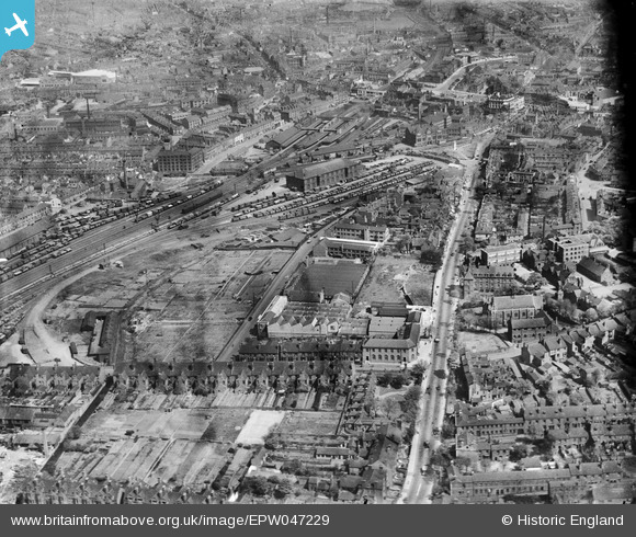
EPW047229 ENGLAND (1935). The Walsall Lithographic Company Works, Bradford Place and the town centre, Walsall, 1935. This image has been produced from a damaged negative.
© Copyright OpenStreetMap contributors and licensed by the OpenStreetMap Foundation. 2024. Cartography is licensed as CC BY-SA.
Nearby Images (20)
Details
| Title | [EPW047229] The Walsall Lithographic Company Works, Bradford Place and the town centre, Walsall, 1935. This image has been produced from a damaged negative. |
| Reference | EPW047229 |
| Date | May-1935 |
| Link | |
| Place name | WALSALL |
| Parish | |
| District | |
| Country | ENGLAND |
| Easting / Northing | 401026, 298130 |
| Longitude / Latitude | -1.9848566041123, 52.580623445284 |
| National Grid Reference | SP010981 |
Pins
Be the first to add a comment to this image!


![[EPW047229] The Walsall Lithographic Company Works, Bradford Place and the town centre, Walsall, 1935. This image has been produced from a damaged negative.](http://britainfromabove.org.uk/sites/all/libraries/aerofilms-images/public/100x100/EPW/047/EPW047229.jpg)
![[EPW047228] The Walsall Lithographic Company Works, Bradford Place and the town centre, Walsall, 1935](http://britainfromabove.org.uk/sites/all/libraries/aerofilms-images/public/100x100/EPW/047/EPW047228.jpg)
![[EPW047231] The Walsall Lithographic Company Works and Walsall Railway Station, Walsall, 1935](http://britainfromabove.org.uk/sites/all/libraries/aerofilms-images/public/100x100/EPW/047/EPW047231.jpg)
![[EPW047233] The Walsall Lithographic Company Works along Midland Road, Walsall, 1935](http://britainfromabove.org.uk/sites/all/libraries/aerofilms-images/public/100x100/EPW/047/EPW047233.jpg)
![[EPW047232] The Walsall Lithographic Company Works, Walsall, 1935](http://britainfromabove.org.uk/sites/all/libraries/aerofilms-images/public/100x100/EPW/047/EPW047232.jpg)
![[EPW047234] The Walsall Lithographic Company Works along Midland Road, Walsall, 1935](http://britainfromabove.org.uk/sites/all/libraries/aerofilms-images/public/100x100/EPW/047/EPW047234.jpg)
![[EPW047226] The Walsall Lithographic Company Works along Midland Road, Walsall, 1935](http://britainfromabove.org.uk/sites/all/libraries/aerofilms-images/public/100x100/EPW/047/EPW047226.jpg)
![[EPW055783] The Co-operative Dairy and the Walsall Lithographic Company Works off Midland Road, Walsall, 1937](http://britainfromabove.org.uk/sites/all/libraries/aerofilms-images/public/100x100/EPW/055/EPW055783.jpg)
![[EPW047227] The Walsall Lithographic Company Works along Midland Road, Walsall, 1935. This image has been produced from a damaged negative.](http://britainfromabove.org.uk/sites/all/libraries/aerofilms-images/public/100x100/EPW/047/EPW047227.jpg)
![[EPW055785] The Co-operative Dairy off Midland Road, Walsall, 1937](http://britainfromabove.org.uk/sites/all/libraries/aerofilms-images/public/100x100/EPW/055/EPW055785.jpg)
![[EPW055784] The Co-operative Dairy off Midland Road, Walsall, 1937](http://britainfromabove.org.uk/sites/all/libraries/aerofilms-images/public/100x100/EPW/055/EPW055784.jpg)
![[EPW055776] The Co-operative Dairy and the Walsall Lithographic Company Works off Midland Road, Walsall, 1937](http://britainfromabove.org.uk/sites/all/libraries/aerofilms-images/public/100x100/EPW/055/EPW055776.jpg)
![[EPW055781] The Co-operative Dairy and the Walsall Lithographic Company Works off Midland Road, Walsall, 1937](http://britainfromabove.org.uk/sites/all/libraries/aerofilms-images/public/100x100/EPW/055/EPW055781.jpg)
![[EPW055786] The Co-operative Dairy off Midland Road, Walsall, 1937](http://britainfromabove.org.uk/sites/all/libraries/aerofilms-images/public/100x100/EPW/055/EPW055786.jpg)
![[EPW055782] The Co-operative Dairy off Midland Road, Walsall, 1937](http://britainfromabove.org.uk/sites/all/libraries/aerofilms-images/public/100x100/EPW/055/EPW055782.jpg)
![[EPW047230] The Walsall Lithographic Company Works and Mere Croft, Walsall, 1935](http://britainfromabove.org.uk/sites/all/libraries/aerofilms-images/public/100x100/EPW/047/EPW047230.jpg)
![[EAW020361] The town centre, Walsall, 1948. This image was marked by Aerofilms Ltd for photo editing.](http://britainfromabove.org.uk/sites/all/libraries/aerofilms-images/public/100x100/EAW/020/EAW020361.jpg)
![[EAW020364] The John Shannon & Sons Ltd Clothing Factory on George Street and the surrounding town, Walsall, from the north-west, 1948. This image was marked by Aerofilms Ltd for photo editing.](http://britainfromabove.org.uk/sites/all/libraries/aerofilms-images/public/100x100/EAW/020/EAW020364.jpg)
![[EPW024715] Bradford Place and the station, Walsall, 1928](http://britainfromabove.org.uk/sites/all/libraries/aerofilms-images/public/100x100/EPW/024/EPW024715.jpg)
![[EAW020362] The town centre, Walsall, 1948. This image was marked by Aerofilms Ltd for photo editing.](http://britainfromabove.org.uk/sites/all/libraries/aerofilms-images/public/100x100/EAW/020/EAW020362.jpg)