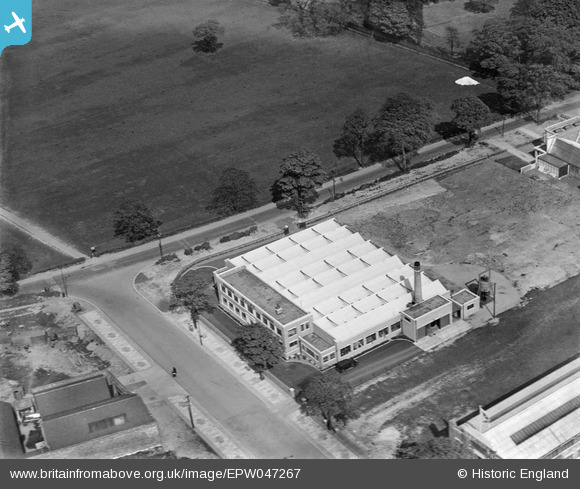
EPW047267 ENGLAND (1935). The Wylex Electrical Works, Wythenshawe, 1935
© Copyright OpenStreetMap contributors and licensed by the OpenStreetMap Foundation. 2025. Cartography is licensed as CC BY-SA.
Nearby Images (9)
Details
| Title | [EPW047267] The Wylex Electrical Works, Wythenshawe, 1935 |
| Reference | EPW047267 |
| Date | May-1935 |
| Link | |
| Place name | WYTHENSHAWE |
| Parish | |
| District | |
| Country | ENGLAND |
| Easting / Northing | 383292, 389407 |
| Longitude / Latitude | -2.2513217216819, 53.400961325423 |
| National Grid Reference | SJ833894 |
Pins
 John Ellis |
Tuesday 25th of November 2014 02:35:17 PM | |
 John Ellis |
Tuesday 25th of November 2014 02:34:42 PM | |
 John Ellis |
Tuesday 25th of November 2014 02:33:59 PM |


![[EPW047267] The Wylex Electrical Works, Wythenshawe, 1935](http://britainfromabove.org.uk/sites/all/libraries/aerofilms-images/public/100x100/EPW/047/EPW047267.jpg)
![[EPW047264] The Wylex Electrical Works and the Moor End Underwear Factory, Wythenshawe, 1935](http://britainfromabove.org.uk/sites/all/libraries/aerofilms-images/public/100x100/EPW/047/EPW047264.jpg)
![[EPW047266] The Wylex Electrical Works and the Moor End Underwear Factory, Wythenshawe, 1935](http://britainfromabove.org.uk/sites/all/libraries/aerofilms-images/public/100x100/EPW/047/EPW047266.jpg)
![[EPW047265] The Wylex Electrical Works and the Washway Embroidery Factory, Wythenshawe, 1935](http://britainfromabove.org.uk/sites/all/libraries/aerofilms-images/public/100x100/EPW/047/EPW047265.jpg)
![[EPW047262] The Wylex Electrical Works and the Washway Embroidery Factory, Wythenshawe, 1935](http://britainfromabove.org.uk/sites/all/libraries/aerofilms-images/public/100x100/EPW/047/EPW047262.jpg)
![[EPW047263] The Wylex Electrical Works and the Washway Embroidery Factory, Wythenshawe, 1935](http://britainfromabove.org.uk/sites/all/libraries/aerofilms-images/public/100x100/EPW/047/EPW047263.jpg)
![[EPW047260] The Wylex Electrical Works, the Washway Embroidery Factory and the Moor End Underwear Factory, Wythenshawe, 1935](http://britainfromabove.org.uk/sites/all/libraries/aerofilms-images/public/100x100/EPW/047/EPW047260.jpg)
![[EPW047261] The Wylex Electrical Works, the Washway Embroidery Factory and the Moor End Underwear Factory, Wythenshawe, 1935](http://britainfromabove.org.uk/sites/all/libraries/aerofilms-images/public/100x100/EPW/047/EPW047261.jpg)
![[EPW017430] Royale Green and environs, Northenden, 1927](http://britainfromabove.org.uk/sites/all/libraries/aerofilms-images/public/100x100/EPW/017/EPW017430.jpg)