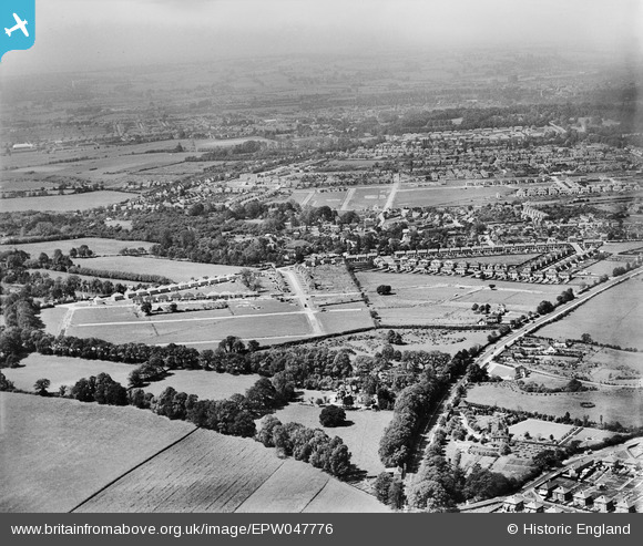
EPW047776 ENGLAND (1935). A housing estate under construction, Risinghurst, from the north-east, 1935
© Copyright OpenStreetMap contributors and licensed by the OpenStreetMap Foundation. 2024. Cartography is licensed as CC BY-SA.
Details
| Title | [EPW047776] A housing estate under construction, Risinghurst, from the north-east, 1935 |
| Reference | EPW047776 |
| Date | June-1935 |
| Link | |
| Place name | RISINGHURST |
| Parish | RISINGHURST AND SANDHILLS |
| District | |
| Country | ENGLAND |
| Easting / Northing | 456121, 207228 |
| Longitude / Latitude | -1.1867603639299, 51.760468064448 |
| National Grid Reference | SP561072 |
Pins
 krintx |
Friday 2nd of August 2019 10:39:26 PM | |
 krintx |
Friday 2nd of August 2019 10:35:07 PM | |
 krintx |
Friday 2nd of August 2019 10:29:52 PM | |
 krintx |
Friday 2nd of August 2019 10:20:25 PM | |
 krintx |
Friday 2nd of August 2019 10:19:44 PM | |
 krintx |
Friday 2nd of August 2019 10:18:13 PM | |
 krintx |
Friday 2nd of August 2019 10:17:25 PM | |
 krintx |
Friday 2nd of August 2019 10:16:48 PM | |
 krintx |
Friday 2nd of August 2019 10:16:22 PM | |
 krintx |
Friday 2nd of August 2019 10:15:06 PM | |
 krintx |
Friday 2nd of August 2019 10:13:49 PM | |
 krintx |
Friday 2nd of August 2019 10:13:10 PM | |
 krintx |
Friday 2nd of August 2019 10:12:24 PM | |
 krintx |
Friday 2nd of August 2019 10:10:34 PM |


![[EPW047776] A housing estate under construction, Risinghurst, from the north-east, 1935](http://britainfromabove.org.uk/sites/all/libraries/aerofilms-images/public/100x100/EPW/047/EPW047776.jpg)
![[EPW047775] A housing estate under construction, Risinghurst, from the east, 1935](http://britainfromabove.org.uk/sites/all/libraries/aerofilms-images/public/100x100/EPW/047/EPW047775.jpg)
![[EAW003875] The Risinghurst Estate, Risinghurst, 1947](http://britainfromabove.org.uk/sites/all/libraries/aerofilms-images/public/100x100/EAW/003/EAW003875.jpg)
![[EAW050077] Housing development at Risinghurst, Sandhills, Barton and Headington Quarry, Risinghurst, 1953](http://britainfromabove.org.uk/sites/all/libraries/aerofilms-images/public/100x100/EAW/050/EAW050077.jpg)