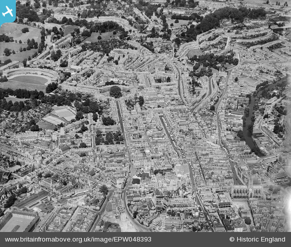
EPW048393 ENGLAND (1935). Gay Street and environs, Bath, from the south-east, 1935
© Copyright OpenStreetMap contributors and licensed by the OpenStreetMap Foundation. 2025. Cartography is licensed as CC BY-SA.
Nearby Images (23)
Details
| Title | [EPW048393] Gay Street and environs, Bath, from the south-east, 1935 |
| Reference | EPW048393 |
| Date | July-1935 |
| Link | |
| Place name | BATH |
| Parish | |
| District | |
| Country | ENGLAND |
| Easting / Northing | 374881, 164935 |
| Longitude / Latitude | -2.3609858695052, 51.382409743618 |
| National Grid Reference | ST749649 |
Pins
 Class31 |
Monday 10th of June 2013 09:25:07 PM |


![[EPW048393] Gay Street and environs, Bath, from the south-east, 1935](http://britainfromabove.org.uk/sites/all/libraries/aerofilms-images/public/100x100/EPW/048/EPW048393.jpg)
![[EPR000129] Queen Square and the city centre, Bath, 1934](http://britainfromabove.org.uk/sites/all/libraries/aerofilms-images/public/100x100/EPR/000/EPR000129.jpg)
![[EPW033154] The city, Bath, from the south-west, 1930](http://britainfromabove.org.uk/sites/all/libraries/aerofilms-images/public/100x100/EPW/033/EPW033154.jpg)
![[EPW001951] Queen Square and environs, Bath, 1920](http://britainfromabove.org.uk/sites/all/libraries/aerofilms-images/public/100x100/EPW/001/EPW001951.jpg)
![[EAW000744] Gay Street, The Circus and environs, Bath, from the south-east, 1946](http://britainfromabove.org.uk/sites/all/libraries/aerofilms-images/public/100x100/EAW/000/EAW000744.jpg)
![[EAW000761] The city, Bath, 1946](http://britainfromabove.org.uk/sites/all/libraries/aerofilms-images/public/100x100/EAW/000/EAW000761.jpg)
![[EAW000745] Gay Street, The Circus and environs, Bath, 1946](http://britainfromabove.org.uk/sites/all/libraries/aerofilms-images/public/100x100/EAW/000/EAW000745.jpg)
![[EPR000133] The Circus and the city centre, Bath, 1934](http://britainfromabove.org.uk/sites/all/libraries/aerofilms-images/public/100x100/EPR/000/EPR000133.jpg)
![[EPW053134] The city centre, Bath, 1937](http://britainfromabove.org.uk/sites/all/libraries/aerofilms-images/public/100x100/EPW/053/EPW053134.jpg)
![[EPW053138] The city centre, Bath, 1937](http://britainfromabove.org.uk/sites/all/libraries/aerofilms-images/public/100x100/EPW/053/EPW053138.jpg)
![[EPW033156] The city, Bath, 1930](http://britainfromabove.org.uk/sites/all/libraries/aerofilms-images/public/100x100/EPW/033/EPW033156.jpg)
![[EPW001958] General view of the town centre, Bath, from the north, 1920](http://britainfromabove.org.uk/sites/all/libraries/aerofilms-images/public/100x100/EPW/001/EPW001958.jpg)
![[EPW053133] The city centre, Bath, 1937](http://britainfromabove.org.uk/sites/all/libraries/aerofilms-images/public/100x100/EPW/053/EPW053133.jpg)
![[EPW053130] The city centre, Bath, 1937](http://britainfromabove.org.uk/sites/all/libraries/aerofilms-images/public/100x100/EPW/053/EPW053130.jpg)
![[EPW053141] The Abbey Church of St Peter and St Paul, the Roman Baths and the city centre, Bath, 1937](http://britainfromabove.org.uk/sites/all/libraries/aerofilms-images/public/100x100/EPW/053/EPW053141.jpg)
![[EPW053127] Pulteney Bridge, St Michael's Church and The Circus, Bath, 1937](http://britainfromabove.org.uk/sites/all/libraries/aerofilms-images/public/100x100/EPW/053/EPW053127.jpg)
![[EAW000760] The Abbey Church of St Peter and St Paul and the surrounding city, Bath, 1946](http://britainfromabove.org.uk/sites/all/libraries/aerofilms-images/public/100x100/EAW/000/EAW000760.jpg)
![[EPW053128] Pulteney Bridge, St Michael's Church and environs, Bath, 1937](http://britainfromabove.org.uk/sites/all/libraries/aerofilms-images/public/100x100/EPW/053/EPW053128.jpg)
![[EAW026456] The city centre, Bath, from the west, 1949](http://britainfromabove.org.uk/sites/all/libraries/aerofilms-images/public/100x100/EAW/026/EAW026456.jpg)
![[EPW001161] View over Bath city centre and the Abbey, Bath, 1920](http://britainfromabove.org.uk/sites/all/libraries/aerofilms-images/public/100x100/EPW/001/EPW001161.jpg)
![[EPW053129] The Tramway Depot, the Cattle Market and Laura Place, Bath, 1937](http://britainfromabove.org.uk/sites/all/libraries/aerofilms-images/public/100x100/EPW/053/EPW053129.jpg)
![[EPW001942] The Abbey Church of St Peter and St Paul and town centre, Bath, 1920](http://britainfromabove.org.uk/sites/all/libraries/aerofilms-images/public/100x100/EPW/001/EPW001942.jpg)
![[EAW000748] The Church of St James, Abbey Church of St Peter and St Paul and the surrounding city, Bath, 1946](http://britainfromabove.org.uk/sites/all/libraries/aerofilms-images/public/100x100/EAW/000/EAW000748.jpg)
