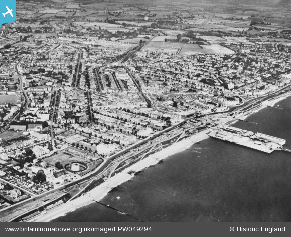
EPW049294 ENGLAND (1935). The town and seafront, Clacton-On-Sea, 1935. This image has been produced from a copy-negative.
© Copyright OpenStreetMap contributors and licensed by the OpenStreetMap Foundation. 2025. Cartography is licensed as CC BY-SA.
Nearby Images (33)
Details
| Title | [EPW049294] The town and seafront, Clacton-On-Sea, 1935. This image has been produced from a copy-negative. |
| Reference | EPW049294 |
| Date | September-1935 |
| Link | |
| Place name | CLACTON-ON-SEA |
| Parish | |
| District | |
| Country | ENGLAND |
| Easting / Northing | 617523, 214634 |
| Longitude / Latitude | 1.154323907837, 51.787552838858 |
| National Grid Reference | TM175146 |
Pins
Be the first to add a comment to this image!


![[EPW049294] The town and seafront, Clacton-On-Sea, 1935. This image has been produced from a copy-negative.](http://britainfromabove.org.uk/sites/all/libraries/aerofilms-images/public/100x100/EPW/049/EPW049294.jpg)
![[EPW039158] The flagstaff beside Pier Gap, Clacton-On-Sea, 1932. This image has been produced from a damaged print.](http://britainfromabove.org.uk/sites/all/libraries/aerofilms-images/public/100x100/EPW/039/EPW039158.jpg)
![[EPW011619] Pier Avenue and environs, Clacton-On-Sea, 1924. This image has been produced from a print.](http://britainfromabove.org.uk/sites/all/libraries/aerofilms-images/public/100x100/EPW/011/EPW011619.jpg)
![[EPW049300] The Pavilion alongside Pier Gap, Clacton-On-Sea, 1935. This image has been produced from a copy-negative.](http://britainfromabove.org.uk/sites/all/libraries/aerofilms-images/public/100x100/EPW/049/EPW049300.jpg)
![[EPW001991] General view of the town centre, Clacton-on-Sea, 1920](http://britainfromabove.org.uk/sites/all/libraries/aerofilms-images/public/100x100/EPW/001/EPW001991.jpg)
![[EAW038332] Holiday-makers on the beach in front of Seafront Gardens, Clacton-On-Sea, 1951. This image has been produced from a print.](http://britainfromabove.org.uk/sites/all/libraries/aerofilms-images/public/100x100/EAW/038/EAW038332.jpg)
![[EPW011621] Beatrice Road and environs, Clacton-On-Sea, 1924. This image has been produced from a copy-negative.](http://britainfromabove.org.uk/sites/all/libraries/aerofilms-images/public/100x100/EPW/011/EPW011621.jpg)
![[EPW058725] The Pavilion, Clacton-On-Sea, 1938. This image has been produced from a copy-negative.](http://britainfromabove.org.uk/sites/all/libraries/aerofilms-images/public/100x100/EPW/058/EPW058725.jpg)
![[EPW011620] The Seafront Gardens and environs, Clacton-On-Sea, 1924. This image has been produced from a copy-negative.](http://britainfromabove.org.uk/sites/all/libraries/aerofilms-images/public/100x100/EPW/011/EPW011620.jpg)
![[EPW011623] Pier Gap and environs, Clacton-On-Sea, 1924. This image has been produced from a copy-negative.](http://britainfromabove.org.uk/sites/all/libraries/aerofilms-images/public/100x100/EPW/011/EPW011623.jpg)
![[EPW039139] The Pavilion, Clacton-on-Sea, 1932](http://britainfromabove.org.uk/sites/all/libraries/aerofilms-images/public/100x100/EPW/039/EPW039139.jpg)
![[EPW011616] The Band Pavilion, Clacton-On-Sea, 1924. This image has been produced from a copy-negative.](http://britainfromabove.org.uk/sites/all/libraries/aerofilms-images/public/100x100/EPW/011/EPW011616.jpg)
![[EPW058724] The Seafront Gardens and environs, Clacton-On-Sea, 1938. This image has been produced from a copy-negative.](http://britainfromabove.org.uk/sites/all/libraries/aerofilms-images/public/100x100/EPW/058/EPW058724.jpg)
![[EAW038331] The Pavilion at Pier Gap, Clacton-On-Sea, 1951. This image has been produced from a print.](http://britainfromabove.org.uk/sites/all/libraries/aerofilms-images/public/100x100/EAW/038/EAW038331.jpg)
![[EPW039138] The Pavilion, Clacton-on-Sea, 1932](http://britainfromabove.org.uk/sites/all/libraries/aerofilms-images/public/100x100/EPW/039/EPW039138.jpg)
![[EPW001863] Rosemary Road and environs, Clacton-On-Sea, 1920. This image has been produced from a print.](http://britainfromabove.org.uk/sites/all/libraries/aerofilms-images/public/100x100/EPW/001/EPW001863.jpg)
![[EPW001870] View of Clacton-on-Sea, pier and Martello Tower, Clacton-on-Sea, 1920](http://britainfromabove.org.uk/sites/all/libraries/aerofilms-images/public/100x100/EPW/001/EPW001870.jpg)
![[EPW058728] Marine Parade East, the seafront and town, Clacton-On-Sea, from the south, 1938. This image has been produced from a copy-negative.](http://britainfromabove.org.uk/sites/all/libraries/aerofilms-images/public/100x100/EPW/058/EPW058728.jpg)
![[EPW049297] Marine Parade East and the town, Clacton-On-Sea, 1935. This image has been produced from a copy-negative.](http://britainfromabove.org.uk/sites/all/libraries/aerofilms-images/public/100x100/EPW/049/EPW049297.jpg)
![[EPW039151] The pier and Marine Parade East, Clacton-On-Sea, 1932. This image has been produced from a print.](http://britainfromabove.org.uk/sites/all/libraries/aerofilms-images/public/100x100/EPW/039/EPW039151.jpg)
![[EPW039150] The pier, pavilion and environs, Clacton-On-Sea, 1932. This image has been produced from a copy-negative.](http://britainfromabove.org.uk/sites/all/libraries/aerofilms-images/public/100x100/EPW/039/EPW039150.jpg)
![[EPW039154] The pier and Marine Parade East, Clacton-on-Sea, 1932](http://britainfromabove.org.uk/sites/all/libraries/aerofilms-images/public/100x100/EPW/039/EPW039154.jpg)
![[EPW039152] The pier and Clacton Seafront Gardens, Clacton-On-Sea, 1932. This image has been produced from a print.](http://britainfromabove.org.uk/sites/all/libraries/aerofilms-images/public/100x100/EPW/039/EPW039152.jpg)
![[EPW039148] The swimming pool on Clacton Pier, Clacton-On-Sea, 1932. This image has been produced from a print.](http://britainfromabove.org.uk/sites/all/libraries/aerofilms-images/public/100x100/EPW/039/EPW039148.jpg)
![[EPW001871] Rosemary Road and Anglefield junction, Clacton-on-Sea, 1920](http://britainfromabove.org.uk/sites/all/libraries/aerofilms-images/public/100x100/EPW/001/EPW001871.jpg)
![[EPW041339] The swimming pool on the Pier, Clacton-On-Sea, 1933](http://britainfromabove.org.uk/sites/all/libraries/aerofilms-images/public/100x100/EPW/041/EPW041339.jpg)
![[EPW039143] The swimming pool on Clacton Pier, Clacton-On-Sea, 1932. This image has been produced from a damaged print.](http://britainfromabove.org.uk/sites/all/libraries/aerofilms-images/public/100x100/EPW/039/EPW039143.jpg)
![[EPW041340] The swimming pool on the Pier, Clacton-On-Sea, 1933](http://britainfromabove.org.uk/sites/all/libraries/aerofilms-images/public/100x100/EPW/041/EPW041340.jpg)
![[EPW039146] The swimming pool on Clacton Pier, Clacton-On-Sea, 1932. This image has been produced from a print.](http://britainfromabove.org.uk/sites/all/libraries/aerofilms-images/public/100x100/EPW/039/EPW039146.jpg)
![[EPW039140] The swimming pool on Clacton Pier, Clacton-on-Sea, 1932](http://britainfromabove.org.uk/sites/all/libraries/aerofilms-images/public/100x100/EPW/039/EPW039140.jpg)
![[EPW041341] The swimming pool on the Pier, Clacton-On-Sea, 1933](http://britainfromabove.org.uk/sites/all/libraries/aerofilms-images/public/100x100/EPW/041/EPW041341.jpg)
![[EPW039142] The pier, Clacton-on-Sea, 1932](http://britainfromabove.org.uk/sites/all/libraries/aerofilms-images/public/100x100/EPW/039/EPW039142.jpg)
![[EPW058704] The pier, Clacton-on-Sea, 1938](http://britainfromabove.org.uk/sites/all/libraries/aerofilms-images/public/100x100/EPW/058/EPW058704.jpg)