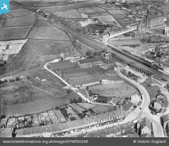
EPW050186 ENGLAND (1936). The E Wilman and Sons Ltd Station Mill and environs, Padfield, 1936
© Copyright OpenStreetMap contributors and licensed by the OpenStreetMap Foundation. 2025. Cartography is licensed as CC BY-SA.
Nearby Images (10)
Details
| Title | [EPW050186] The E Wilman and Sons Ltd Station Mill and environs, Padfield, 1936 |
| Reference | EPW050186 |
| Date | May-1936 |
| Link | |
| Place name | PADFIELD |
| Parish | |
| District | |
| Country | ENGLAND |
| Easting / Northing | 402471, 396196 |
| Longitude / Latitude | -1.9627777452565, 53.462250145867 |
| National Grid Reference | SK025962 |
Pins
 JPS |
Monday 10th of October 2016 09:30:20 PM | |
 J.Smith |
Sunday 24th of August 2014 01:20:52 PM | |
 J.Smith |
Sunday 24th of August 2014 01:20:05 PM | |
 J.Smith |
Sunday 24th of August 2014 01:19:11 PM | |
 J.Smith |
Sunday 24th of August 2014 01:17:35 PM |


![[EPW050186] The E Wilman and Sons Ltd Station Mill and environs, Padfield, 1936](http://britainfromabove.org.uk/sites/all/libraries/aerofilms-images/public/100x100/EPW/050/EPW050186.jpg)
![[EPW050189] The E Wilman and Sons Ltd Station Mill, Padfield, 1936](http://britainfromabove.org.uk/sites/all/libraries/aerofilms-images/public/100x100/EPW/050/EPW050189.jpg)
![[EPW050187] The E Wilman and Sons Ltd Station Mill, Padfield, 1936](http://britainfromabove.org.uk/sites/all/libraries/aerofilms-images/public/100x100/EPW/050/EPW050187.jpg)
![[EPW050183] The E Wilman and Sons Ltd Station Mill, Padfield, 1936](http://britainfromabove.org.uk/sites/all/libraries/aerofilms-images/public/100x100/EPW/050/EPW050183.jpg)
![[EPW050190] The E Wilman and Sons Ltd Station Mill, Padfield, 1936](http://britainfromabove.org.uk/sites/all/libraries/aerofilms-images/public/100x100/EPW/050/EPW050190.jpg)
![[EPW050185] The E Wilman and Sons Ltd Station Mill with Hadfield Mills in the distance, Padfield, 1936](http://britainfromabove.org.uk/sites/all/libraries/aerofilms-images/public/100x100/EPW/050/EPW050185.jpg)
![[EPW050181] The E Wilman and Sons Ltd Station Mill with Hadfield Mills in the distance, Padfield, 1936](http://britainfromabove.org.uk/sites/all/libraries/aerofilms-images/public/100x100/EPW/050/EPW050181.jpg)
![[EPW050188] Platt Street and the E Wilman and Sons Ltd Station Mill, Padfield, 1936](http://britainfromabove.org.uk/sites/all/libraries/aerofilms-images/public/100x100/EPW/050/EPW050188.jpg)
![[EPW050182] The E Wilman and Sons Ltd Station Mill and environs, Padfield, 1936](http://britainfromabove.org.uk/sites/all/libraries/aerofilms-images/public/100x100/EPW/050/EPW050182.jpg)
![[EPW050184] The E Wilman and Sons Ltd Station Mill, Padfield, 1936](http://britainfromabove.org.uk/sites/all/libraries/aerofilms-images/public/100x100/EPW/050/EPW050184.jpg)