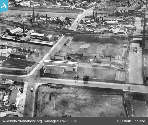
EPW050520 ENGLAND (1936). Vernons Pools Ltd on Linacre Lane and environs, Bootle, 1936
© Copyright OpenStreetMap contributors and licensed by the OpenStreetMap Foundation. 2025. Cartography is licensed as CC BY-SA.
Nearby Images (27)
Details
| Title | [EPW050520] Vernons Pools Ltd on Linacre Lane and environs, Bootle, 1936 |
| Reference | EPW050520 |
| Date | June-1936 |
| Link | |
| Place name | BOOTLE |
| Parish | |
| District | |
| Country | ENGLAND |
| Easting / Northing | 334625, 396289 |
| Longitude / Latitude | -2.9847251111659, 53.459034289018 |
| National Grid Reference | SJ346963 |
Pins
 rivermersey |
Wednesday 19th of August 2020 12:59:59 PM | |
 rivermersey |
Wednesday 19th of August 2020 12:10:25 PM | |
 rivermersey |
Wednesday 19th of August 2020 12:02:26 PM | |
 alan |
Monday 6th of April 2020 01:19:25 AM | |
 alan |
Monday 6th of April 2020 01:17:54 AM | |
 bob |
Tuesday 5th of November 2019 10:31:57 AM | |
 bob |
Wednesday 3rd of July 2019 06:08:30 PM | |
 bob |
Wednesday 3rd of July 2019 06:07:29 PM | |
 alan |
Thursday 22nd of October 2015 08:15:15 PM | |
 alan |
Thursday 22nd of October 2015 08:14:31 PM | |
 alan |
Thursday 22nd of October 2015 08:13:45 PM |


![[EPW050520] Vernons Pools Ltd on Linacre Lane and environs, Bootle, 1936](http://britainfromabove.org.uk/sites/all/libraries/aerofilms-images/public/100x100/EPW/050/EPW050520.jpg)
![[EAW036946] The Liverpool Electric Cable Co Ltd Works, Bootle, 1951. This image has been produced from a print marked by Aerofilms Ltd for photo editing.](http://britainfromabove.org.uk/sites/all/libraries/aerofilms-images/public/100x100/EAW/036/EAW036946.jpg)
![[EPW025316] Liverpool Electric Cable Co Works, Bootle, 1928](http://britainfromabove.org.uk/sites/all/libraries/aerofilms-images/public/100x100/EPW/025/EPW025316.jpg)
![[EPR000196] The Liverpool Electric Cable Co Works off Linacre Road, Bootle, 1934. This image has been affected by flare.](http://britainfromabove.org.uk/sites/all/libraries/aerofilms-images/public/100x100/EPR/000/EPR000196.jpg)
![[EAW036949] The Liverpool Electric Cable Co Ltd Works, Bootle, 1951. This image has been produced from a print marked by Aerofilms Ltd for photo editing.](http://britainfromabove.org.uk/sites/all/libraries/aerofilms-images/public/100x100/EAW/036/EAW036949.jpg)
![[EAW036948] The Liverpool Electric Cable Co Ltd Works, Bootle, 1951. This image has been produced from a print marked by Aerofilms Ltd for photo editing.](http://britainfromabove.org.uk/sites/all/libraries/aerofilms-images/public/100x100/EAW/036/EAW036948.jpg)
![[EPW025314] Liverpool Electric Cable Co Works and the Mersey Cable Works, Bootle, 1928](http://britainfromabove.org.uk/sites/all/libraries/aerofilms-images/public/100x100/EPW/025/EPW025314.jpg)
![[EAW036059] The Liverpool Electric Cable Co Ltd Works off Linacre Lane, Bootle, 1951. This image has been produced from a print marked by Aerofilms Ltd for photo editing.](http://britainfromabove.org.uk/sites/all/libraries/aerofilms-images/public/100x100/EAW/036/EAW036059.jpg)
![[EAW036058] The Liverpool Electric Cable Co Ltd Works off Linacre Lane, Bootle, 1951. This image has been produced from a print marked by Aerofilms Ltd for photo editing.](http://britainfromabove.org.uk/sites/all/libraries/aerofilms-images/public/100x100/EAW/036/EAW036058.jpg)
![[EAW036057] The Liverpool Electric Cable Co Ltd Works off Linacre Lane, Bootle, 1951. This image has been produced from a print marked by Aerofilms Ltd for photo editing.](http://britainfromabove.org.uk/sites/all/libraries/aerofilms-images/public/100x100/EAW/036/EAW036057.jpg)
![[EAW036947] The Liverpool Electric Cable Co Ltd Works, Bootle, 1951. This image has been produced from a print marked by Aerofilms Ltd for photo editing.](http://britainfromabove.org.uk/sites/all/libraries/aerofilms-images/public/100x100/EAW/036/EAW036947.jpg)
![[EPW025319] Liverpool Electric Cable Co Works and the Mersey Cable Works, Bootle, 1928](http://britainfromabove.org.uk/sites/all/libraries/aerofilms-images/public/100x100/EPW/025/EPW025319.jpg)
![[EAW036060] The Liverpool Electric Cable Co Ltd Works off Linacre Lane, Bootle, 1951. This image has been produced from a print marked by Aerofilms Ltd for photo editing.](http://britainfromabove.org.uk/sites/all/libraries/aerofilms-images/public/100x100/EAW/036/EAW036060.jpg)
![[EAW036944] The Liverpool Electric Cable Co Ltd Works, Bootle, 1951. This image has been produced from a print marked by Aerofilms Ltd for photo editing.](http://britainfromabove.org.uk/sites/all/libraries/aerofilms-images/public/100x100/EAW/036/EAW036944.jpg)
![[EAW036943] The Liverpool Electric Cable Co Ltd Works, Bootle, 1951. This image has been produced from a print marked by Aerofilms Ltd for photo editing.](http://britainfromabove.org.uk/sites/all/libraries/aerofilms-images/public/100x100/EAW/036/EAW036943.jpg)
![[EPW025315] Liverpool Electric Cable Co Works and the Mersey Cable Works, Bootle, 1928](http://britainfromabove.org.uk/sites/all/libraries/aerofilms-images/public/100x100/EPW/025/EPW025315.jpg)
![[EAW036063] The Liverpool Electric Cable Co Ltd Works off Linacre Lane, Bootle, 1951. This image has been produced from a print marked by Aerofilms Ltd for photo editing.](http://britainfromabove.org.uk/sites/all/libraries/aerofilms-images/public/100x100/EAW/036/EAW036063.jpg)
![[EAW036056] The Liverpool Electric Cable Co Ltd Works off Linacre Lane, Bootle, 1951. This image has been produced from a print marked by Aerofilms Ltd for photo editing.](http://britainfromabove.org.uk/sites/all/libraries/aerofilms-images/public/100x100/EAW/036/EAW036056.jpg)
![[EAW036062] The Liverpool Electric Cable Co Ltd Works off Linacre Lane, Bootle, 1951. This image has been produced from a print marked by Aerofilms Ltd for photo editing.](http://britainfromabove.org.uk/sites/all/libraries/aerofilms-images/public/100x100/EAW/036/EAW036062.jpg)
![[EAW036941] The Liverpool Electric Cable Co Ltd Works, Bootle, 1951. This image has been produced from a print marked by Aerofilms Ltd for photo editing.](http://britainfromabove.org.uk/sites/all/libraries/aerofilms-images/public/100x100/EAW/036/EAW036941.jpg)
![[EAW036942] The Liverpool Electric Cable Co Ltd Works, Bootle, 1951. This image has been produced from a print marked by Aerofilms Ltd for photo editing.](http://britainfromabove.org.uk/sites/all/libraries/aerofilms-images/public/100x100/EAW/036/EAW036942.jpg)
![[EAW036055] The Liverpool Electric Cable Co Ltd Works off Linacre Lane, Bootle, 1951. This image has been produced from a print marked by Aerofilms Ltd for photo editing.](http://britainfromabove.org.uk/sites/all/libraries/aerofilms-images/public/100x100/EAW/036/EAW036055.jpg)
![[EPW025312] Liverpool Electric Cable Co Works and the Mersey Cable Works, Bootle, 1928](http://britainfromabove.org.uk/sites/all/libraries/aerofilms-images/public/100x100/EPW/025/EPW025312.jpg)
![[EPW025313] Liverpool Electric Cable Co Works and the Mersey Cable Works, Bootle, 1928](http://britainfromabove.org.uk/sites/all/libraries/aerofilms-images/public/100x100/EPW/025/EPW025313.jpg)
![[EAW036945] The Liverpool Electric Cable Co Ltd Works, Bootle, 1951. This image has been produced from a print marked by Aerofilms Ltd for photo editing.](http://britainfromabove.org.uk/sites/all/libraries/aerofilms-images/public/100x100/EAW/036/EAW036945.jpg)
![[EAW036061] The Liverpool Electric Cable Co Ltd Works off Linacre Lane, Bootle, 1951. This image has been produced from a print marked by Aerofilms Ltd for photo editing.](http://britainfromabove.org.uk/sites/all/libraries/aerofilms-images/public/100x100/EAW/036/EAW036061.jpg)
![[EPW011168] The Linacre Gas Works, Bootle, 1924](http://britainfromabove.org.uk/sites/all/libraries/aerofilms-images/public/100x100/EPW/011/EPW011168.jpg)