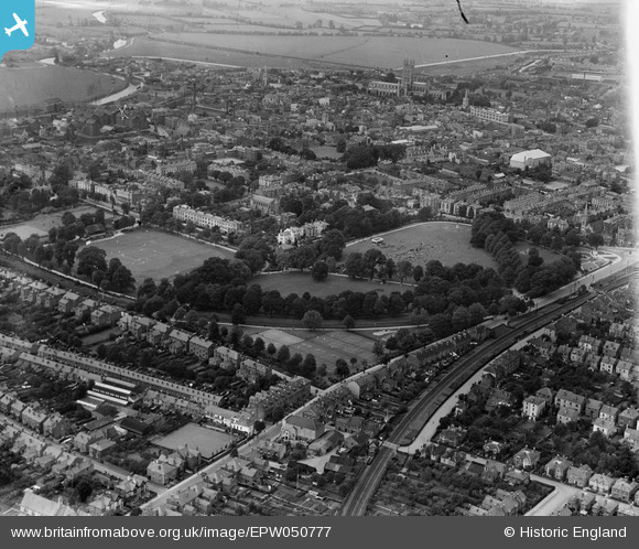
EPW050777 ENGLAND (1936). The Park and the city, Gloucester, 1936
© Copyright OpenStreetMap contributors and licensed by the OpenStreetMap Foundation. 2025. Cartography is licensed as CC BY-SA.
Nearby Images (11)
Details
| Title | [EPW050777] The Park and the city, Gloucester, 1936 |
| Reference | EPW050777 |
| Date | June-1936 |
| Link | |
| Place name | GLOUCESTER |
| Parish | |
| District | |
| Country | ENGLAND |
| Easting / Northing | 383232, 217858 |
| Longitude / Latitude | -2.2435087617539, 51.858614367837 |
| National Grid Reference | SO832179 |
Pins
 Richcl |
Sunday 5th of May 2013 03:40:41 PM |


![[EPW050777] The Park and the city, Gloucester, 1936](http://britainfromabove.org.uk/sites/all/libraries/aerofilms-images/public/100x100/EPW/050/EPW050777.jpg)
![[EPW050780] The Park, Spa Field and the city centre, Gloucester, 1936](http://britainfromabove.org.uk/sites/all/libraries/aerofilms-images/public/100x100/EPW/050/EPW050780.jpg)
![[EPW050779] Crowds gathered around the Bandstand in The Park, Gloucester, 1936](http://britainfromabove.org.uk/sites/all/libraries/aerofilms-images/public/100x100/EPW/050/EPW050779.jpg)
![[EPW024162] The Park, Gloucester, 1928](http://britainfromabove.org.uk/sites/all/libraries/aerofilms-images/public/100x100/EPW/024/EPW024162.jpg)
![[EPW050778] The Park, Spa Field and the city centre, Gloucester, 1936](http://britainfromabove.org.uk/sites/all/libraries/aerofilms-images/public/100x100/EPW/050/EPW050778.jpg)
![[EPW050785] A cricket match being played on the Spa Field, Gloucester, 1936](http://britainfromabove.org.uk/sites/all/libraries/aerofilms-images/public/100x100/EPW/050/EPW050785.jpg)
![[EPW050784] A cricket match being played on the Spa Field, Gloucester, 1936](http://britainfromabove.org.uk/sites/all/libraries/aerofilms-images/public/100x100/EPW/050/EPW050784.jpg)
![[EPW050782] The Presbyterian Church and The Park, Gloucester, 1936](http://britainfromabove.org.uk/sites/all/libraries/aerofilms-images/public/100x100/EPW/050/EPW050782.jpg)
![[EPW050781] The Park, Spa Field and the city centre, Gloucester, 1936](http://britainfromabove.org.uk/sites/all/libraries/aerofilms-images/public/100x100/EPW/050/EPW050781.jpg)
![[EPW050783] The Spa Field and the city centre, Gloucester, 1936](http://britainfromabove.org.uk/sites/all/libraries/aerofilms-images/public/100x100/EPW/050/EPW050783.jpg)
![[EPW024171] The area between Park Road and the railway station, Gloucester, 1928](http://britainfromabove.org.uk/sites/all/libraries/aerofilms-images/public/100x100/EPW/024/EPW024171.jpg)