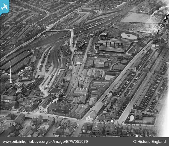
EPW051079 ENGLAND (1936). The British Ropes Ltd Hemp and Rope Works in Monkwearmouth, Sunderland, 1936. This image was marked by Aerofilms Ltd for photo editing.
© Copyright OpenStreetMap contributors and licensed by the OpenStreetMap Foundation. 2025. Cartography is licensed as CC BY-SA.
Nearby Images (7)
Details
| Title | [EPW051079] The British Ropes Ltd Hemp and Rope Works in Monkwearmouth, Sunderland, 1936. This image was marked by Aerofilms Ltd for photo editing. |
| Reference | EPW051079 |
| Date | July-1936 |
| Link | |
| Place name | SUNDERLAND |
| Parish | |
| District | |
| Country | ENGLAND |
| Easting / Northing | 439856, 558216 |
| Longitude / Latitude | -1.3781627070942, 54.916970072959 |
| National Grid Reference | NZ399582 |
Pins
 kevin n |
Friday 29th of November 2013 12:01:16 PM | |
 Barbary Coaster |
Friday 9th of August 2013 10:49:54 PM | |
 Barbary Coaster |
Friday 9th of August 2013 10:47:24 PM | |
 Barbary Coaster |
Friday 9th of August 2013 10:43:09 PM | |
 MalcolmGH |
Thursday 9th of May 2013 09:05:54 AM |
User Comment Contributions
Tyzack Concrete works Now a Residential area |
 Barbary Coaster |
Friday 9th of August 2013 10:44:26 PM |
My old house is at the very top of this photograph, and it looks like the builders are just finishing it off! |
 MalcolmGH |
Thursday 9th of May 2013 09:04:40 AM |


![[EPW051079] The British Ropes Ltd Hemp and Rope Works in Monkwearmouth, Sunderland, 1936. This image was marked by Aerofilms Ltd for photo editing.](http://britainfromabove.org.uk/sites/all/libraries/aerofilms-images/public/100x100/EPW/051/EPW051079.jpg)
![[EPW051080] The British Ropes Ltd Hemp and Rope Works in Monkwearmouth, Sunderland, 1936. This image has been produced from a damaged negative.](http://britainfromabove.org.uk/sites/all/libraries/aerofilms-images/public/100x100/EPW/051/EPW051080.jpg)
![[EPW051082] The British Ropes Ltd Hemp and Rope Works in Monkwearmouth, Sunderland, 1936. This image was marked by Aerofilms Ltd for photo editing.](http://britainfromabove.org.uk/sites/all/libraries/aerofilms-images/public/100x100/EPW/051/EPW051082.jpg)
![[EPW051081] The British Ropes Ltd Hemp and Rope Works in Monkwearmouth, Sunderland, 1936](http://britainfromabove.org.uk/sites/all/libraries/aerofilms-images/public/100x100/EPW/051/EPW051081.jpg)
![[EPW051077] The British Ropes Ltd Hemp and Rope Works in Monkwearmouth, Sunderland, 1936](http://britainfromabove.org.uk/sites/all/libraries/aerofilms-images/public/100x100/EPW/051/EPW051077.jpg)
![[EPW051083] The British Ropes Ltd Hemp and Rope Works and environs in Monkwearmouth, Sunderland, 1936](http://britainfromabove.org.uk/sites/all/libraries/aerofilms-images/public/100x100/EPW/051/EPW051083.jpg)
![[EPW051078] The British Ropes Ltd Hemp and Rope Works and environs in Monkwearmouth, Sunderland, 1936](http://britainfromabove.org.uk/sites/all/libraries/aerofilms-images/public/100x100/EPW/051/EPW051078.jpg)