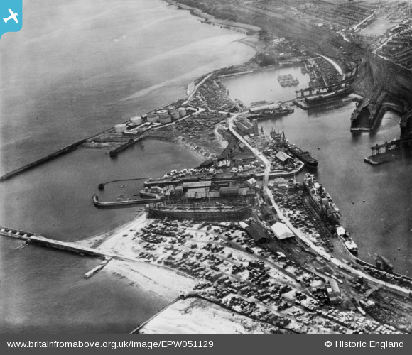
EPW051129 ENGLAND (1936). Hudson Dock Channel and environs, Sunderland, 1936. This image has been produced from copy-negative.
© Copyright OpenStreetMap contributors and licensed by the OpenStreetMap Foundation. 2025. Cartography is licensed as CC BY-SA.
Nearby Images (5)
Details
| Title | [EPW051129] Hudson Dock Channel and environs, Sunderland, 1936. This image has been produced from copy-negative. |
| Reference | EPW051129 |
| Date | July-1936 |
| Link | |
| Place name | SUNDERLAND |
| Parish | |
| District | |
| Country | ENGLAND |
| Easting / Northing | 441356, 557017 |
| Longitude / Latitude | -1.3549335113272, 54.906072943967 |
| National Grid Reference | NZ414570 |
Pins
Be the first to add a comment to this image!


![[EPW051129] Hudson Dock Channel and environs, Sunderland, 1936. This image has been produced from copy-negative.](http://britainfromabove.org.uk/sites/all/libraries/aerofilms-images/public/100x100/EPW/051/EPW051129.jpg)
![[EAW022799] MV "Andulo" at Hudson Dock South, Sunderland, 1949](http://britainfromabove.org.uk/sites/all/libraries/aerofilms-images/public/100x100/EAW/022/EAW022799.jpg)
![[EAW001014] The Hudson Dock South, the South Outlet and the Hendon Railway Junction, Sunderland, 1946. This image has been produced from a damaged negative.](http://britainfromabove.org.uk/sites/all/libraries/aerofilms-images/public/100x100/EAW/001/EAW001014.jpg)
![[EAW001015] The Hudson Dock North, the South Dock Shipbuilding Yard and the Hendon Railway Junction, Sunderland, 1946](http://britainfromabove.org.uk/sites/all/libraries/aerofilms-images/public/100x100/EAW/001/EAW001015.jpg)
![[EPW020532] Hendon and Hudson Docks, Sunderland, 1928](http://britainfromabove.org.uk/sites/all/libraries/aerofilms-images/public/100x100/EPW/020/EPW020532.jpg)