
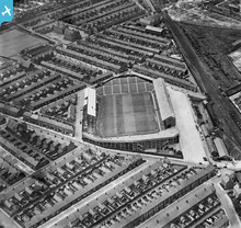
EPW051130 ENGLAND (1936). Roker Park Football Ground, Sunderland, 1936

© Copyright OpenStreetMap contributors and licensed by the OpenStreetMap Foundation. 2025. Cartography is licensed as CC BY-SA.
Details
| Title | [EPW051130] Roker Park Football Ground, Sunderland, 1936 |
| Reference | EPW051130 |
| Date | July-1936 |
| Link | |
| Place name | SUNDERLAND |
| Parish | |
| District | |
| Country | ENGLAND |
| Easting / Northing | 440120, 558669 |
| Longitude / Latitude | -1.3739808326361, 54.921019952795 |
| National Grid Reference | NZ401587 |
Pins
 Billy Turner |
Friday 29th of March 2024 01:46:27 PM | |
 Davison |
Monday 21st of April 2014 08:52:30 PM | |
Davison |
Monday 21st of April 2014 08:50:27 PM | |
kevin n |
Thursday 19th of December 2013 01:16:49 PM | |
kevin n |
Friday 29th of November 2013 11:55:40 AM | |
kevin n |
Friday 29th of November 2013 11:53:48 AM | |
Steve A |
Friday 23rd of August 2013 04:05:43 PM | |
My school after we came to Sunderland from Dover in 1936. |
Wallace Oliver |
Sunday 16th of February 2014 01:31:00 AM |
User Comment Contributions
 Sunderland AFC 1897 to 1997 |
SheerFortitude |
Thursday 9th of May 2013 02:06:36 PM |