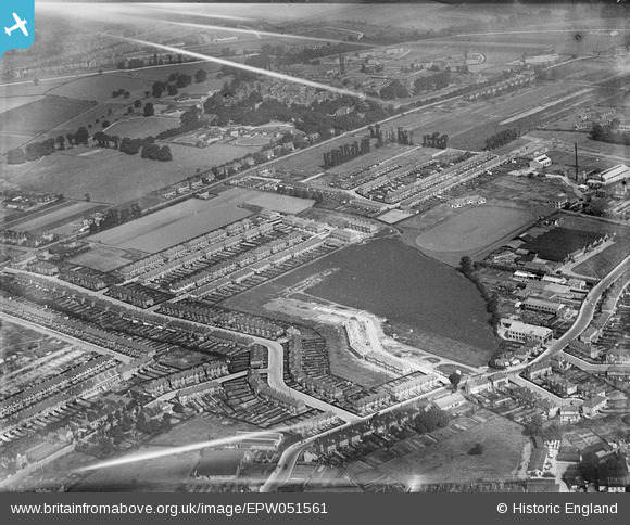
EPW051561 ENGLAND (1936). Housing under contruction at Christie Gardens and environs, Seven Kings, 1936
© Copyright OpenStreetMap contributors and licensed by the OpenStreetMap Foundation. 2025. Cartography is licensed as CC BY-SA.
Nearby Images (15)
Details
| Title | [EPW051561] Housing under contruction at Christie Gardens and environs, Seven Kings, 1936 |
| Reference | EPW051561 |
| Date | August-1936 |
| Link | |
| Place name | SEVEN KINGS |
| Parish | |
| District | |
| Country | ENGLAND |
| Easting / Northing | 546741, 188080 |
| Longitude / Latitude | 0.11768567296545, 51.571990398762 |
| National Grid Reference | TQ467881 |
Pins
Be the first to add a comment to this image!


![[EPW051561] Housing under contruction at Christie Gardens and environs, Seven Kings, 1936](http://britainfromabove.org.uk/sites/all/libraries/aerofilms-images/public/100x100/EPW/051/EPW051561.jpg)
![[EPW051557] Housing development off Primrose Avenue and environs, Seven Kings, 1936](http://britainfromabove.org.uk/sites/all/libraries/aerofilms-images/public/100x100/EPW/051/EPW051557.jpg)
![[EPW051560] Housing development off Primrose Avenue, Mannin Road and environs, Seven Kings, 1936](http://britainfromabove.org.uk/sites/all/libraries/aerofilms-images/public/100x100/EPW/051/EPW051560.jpg)
![[EPW051564] Housing under contruction at Christie Gardens and environs, Seven Kings, 1936](http://britainfromabove.org.uk/sites/all/libraries/aerofilms-images/public/100x100/EPW/051/EPW051564.jpg)
![[EPW051558] Housing development off Primrose Avenue and environs, Seven Kings, 1936](http://britainfromabove.org.uk/sites/all/libraries/aerofilms-images/public/100x100/EPW/051/EPW051558.jpg)
![[EPW051559] Housing development off Primrose Avenue and environs, Seven Kings, 1936](http://britainfromabove.org.uk/sites/all/libraries/aerofilms-images/public/100x100/EPW/051/EPW051559.jpg)
![[EAW020746] Stationery Works on Grove Road, Little Heath, 1949. This image was marked by Aerofilms Ltd for photo editing.](http://britainfromabove.org.uk/sites/all/libraries/aerofilms-images/public/100x100/EAW/020/EAW020746.jpg)
![[EAW020748] Stationery Works on Grove Road, Little Heath, 1949. This image was marked by Aerofilms Ltd for photo editing.](http://britainfromabove.org.uk/sites/all/libraries/aerofilms-images/public/100x100/EAW/020/EAW020748.jpg)
![[EAW020749] Stationery Works on Grove Road and environs, Little Heath, 1949. This image was marked by Aerofilms Ltd for photo editing.](http://britainfromabove.org.uk/sites/all/libraries/aerofilms-images/public/100x100/EAW/020/EAW020749.jpg)
![[EAW020750] Stationery Works on Grove Road, Little Heath, 1949. This image was marked by Aerofilms Ltd for photo editing.](http://britainfromabove.org.uk/sites/all/libraries/aerofilms-images/public/100x100/EAW/020/EAW020750.jpg)
![[EPW046796] The Ship Carbon Co Works, Goodmayes Hospital and the surrounding area, Little Heath, 1935](http://britainfromabove.org.uk/sites/all/libraries/aerofilms-images/public/100x100/EPW/046/EPW046796.jpg)
![[EAW020752] Stationery Works on Grove Road, Little Heath, 1949](http://britainfromabove.org.uk/sites/all/libraries/aerofilms-images/public/100x100/EAW/020/EAW020752.jpg)
![[EPW046777] The Ship Carbon Co Works, Little Heath, 1935](http://britainfromabove.org.uk/sites/all/libraries/aerofilms-images/public/100x100/EPW/046/EPW046777.jpg)
![[EPW046778] The Ship Carbon Co Works, Little Heath, 1935](http://britainfromabove.org.uk/sites/all/libraries/aerofilms-images/public/100x100/EPW/046/EPW046778.jpg)
![[EPW046779] The Ship Carbon Co Works and the Ilford Isolation Hospital, Little Heath, 1935](http://britainfromabove.org.uk/sites/all/libraries/aerofilms-images/public/100x100/EPW/046/EPW046779.jpg)