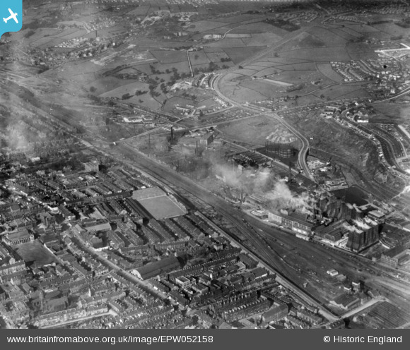
EPW052158 ENGLAND (1936). Valley Parade Football Ground, Valley Road Gas Works and environs, Bradford, 1936. This image has been produced from a print.
© Copyright OpenStreetMap contributors and licensed by the OpenStreetMap Foundation. 2025. Cartography is licensed as CC BY-SA.
Details
| Title | [EPW052158] Valley Parade Football Ground, Valley Road Gas Works and environs, Bradford, 1936. This image has been produced from a print. |
| Reference | EPW052158 |
| Date | October-1936 |
| Link | |
| Place name | BRADFORD |
| Parish | |
| District | |
| Country | ENGLAND |
| Easting / Northing | 416103, 434508 |
| Longitude / Latitude | -1.7554478377762, 53.806403136785 |
| National Grid Reference | SE161345 |
Pins
 david |
Friday 5th of January 2024 04:31:38 AM | |
 david |
Friday 5th of January 2024 04:29:45 AM | |
 david |
Friday 5th of January 2024 04:24:51 AM | |
 david |
Friday 5th of January 2024 04:22:33 AM | |
 david |
Friday 5th of January 2024 04:21:19 AM | |
 david |
Friday 5th of January 2024 04:20:20 AM | |
 david |
Friday 5th of January 2024 04:18:16 AM | |
 david |
Friday 5th of January 2024 04:15:45 AM | |
 david |
Friday 5th of January 2024 04:14:50 AM | |
 david |
Friday 5th of January 2024 04:13:42 AM | |
 david |
Friday 5th of January 2024 04:13:01 AM | |
 H.J.Hill |
Thursday 13th of November 2014 05:25:15 PM | |
 H.J.Hill |
Thursday 13th of November 2014 05:24:27 PM |


![[EPW052158] Valley Parade Football Ground, Valley Road Gas Works and environs, Bradford, 1936. This image has been produced from a print.](http://britainfromabove.org.uk/sites/all/libraries/aerofilms-images/public/100x100/EPW/052/EPW052158.jpg)
![[EPW054322] The Valley Road Gas Works, Bradford, 1937](http://britainfromabove.org.uk/sites/all/libraries/aerofilms-images/public/100x100/EPW/054/EPW054322.jpg)
![[EPW057187] The Valley Road Gas Works and the surrounding industrial area, Manningham, 1938](http://britainfromabove.org.uk/sites/all/libraries/aerofilms-images/public/100x100/EPW/057/EPW057187.jpg)
