
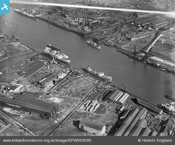
EPW053695 ENGLAND (1937). The River Tyne between the Wallsend Slipway and Engineering Works and Jarrow Staith, Wallsend, 1937
© Copyright OpenStreetMap contributors and licensed by the OpenStreetMap Foundation. 2025. Cartography is licensed as CC BY-SA.
Nearby Images (6)
EPW053695

EPW050744

EAW017411

EAW017405

EPW054562

EAW017404

Details
| Title | [EPW053695] The River Tyne between the Wallsend Slipway and Engineering Works and Jarrow Staith, Wallsend, 1937 |
| Reference | EPW053695 |
| Date | 15-June-1937 |
| Link | |
| Place name | WALLSEND |
| Parish | |
| District | |
| Country | ENGLAND |
| Easting / Northing | 431712, 566073 |
| Longitude / Latitude | -1.504352089793, 54.988164195133 |
| National Grid Reference | NZ317661 |
Pins
 RupertHughes |
Tuesday 2nd of March 2021 09:13:11 PM | |
Florencio |
Friday 26th of February 2021 06:30:33 PM | |
Yes it is :) |
SamAslan |
Thursday 11th of November 2021 05:23:41 PM |
N Dunn |
Saturday 3rd of May 2014 11:26:20 AM | |
Eric Hollerton |
Saturday 21st of September 2013 08:41:54 PM | |
N Dunn |
Wednesday 7th of August 2013 08:20:18 PM | |
N Dunn |
Wednesday 7th of August 2013 08:18:59 PM | |
N Dunn |
Wednesday 7th of August 2013 08:14:25 PM | |
N Dunn |
Wednesday 7th of August 2013 08:13:21 PM |
User Comment Contributions
If you look carefully in the top left corner you can see the remains of the RMS Olympic. This image is taken shortly before she is removed to Inverkeithing for final demolition and Wards began work on dismantling the old Palmers Works and the Aerial Cranes. |
.jpg) ThosWWardLtdResearch |
Wednesday 16th of April 2014 08:03:26 PM |