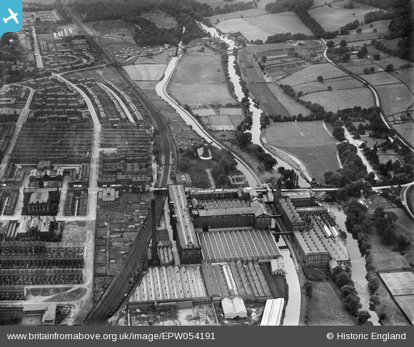
EPW054191 ENGLAND (1937). Salt's Mill, Saltaire, 1937
© Copyright OpenStreetMap contributors and licensed by the OpenStreetMap Foundation. 2025. Cartography is licensed as CC BY-SA.
Nearby Images (9)
Details
| Title | [EPW054191] Salt's Mill, Saltaire, 1937 |
| Reference | EPW054191 |
| Date | 13-July-1937 |
| Link | |
| Place name | SALTAIRE |
| Parish | |
| District | |
| Country | ENGLAND |
| Easting / Northing | 413879, 438109 |
| Longitude / Latitude | -1.7890603701838, 53.838836327028 |
| National Grid Reference | SE139381 |
Pins
 Shipley Flyer |
Wednesday 8th of March 2017 05:57:14 PM | |
 John W |
Monday 8th of August 2016 03:51:46 PM | |
 John W |
Monday 8th of August 2016 03:48:55 PM | |
 John W |
Monday 8th of August 2016 03:48:29 PM |


![[EPW054191] Salt's Mill, Saltaire, 1937](http://britainfromabove.org.uk/sites/all/libraries/aerofilms-images/public/100x100/EPW/054/EPW054191.jpg)
![[EPW054192] Salt's Mill, Saltaire, 1937](http://britainfromabove.org.uk/sites/all/libraries/aerofilms-images/public/100x100/EPW/054/EPW054192.jpg)
![[EPW054197] Salt's Mill and the Congregational Church, Saltaire, 1937](http://britainfromabove.org.uk/sites/all/libraries/aerofilms-images/public/100x100/EPW/054/EPW054197.jpg)
![[EPW054199] The Congregational Church and Roberts Park, Saltaire, 1937](http://britainfromabove.org.uk/sites/all/libraries/aerofilms-images/public/100x100/EPW/054/EPW054199.jpg)
![[EPW024515] The Saltaire Mills, Saltaire, 1928. This image has been produced from a copy-negative.](http://britainfromabove.org.uk/sites/all/libraries/aerofilms-images/public/100x100/EPW/024/EPW024515.jpg)
![[EPW054202] The playing fields in-between the River Aire and the Leeds and Liverpool Canal and Roberts Park, Saltaire, 1937](http://britainfromabove.org.uk/sites/all/libraries/aerofilms-images/public/100x100/EPW/054/EPW054202.jpg)
![[EPW054206] Salt's Mill, Saltaire, 1937](http://britainfromabove.org.uk/sites/all/libraries/aerofilms-images/public/100x100/EPW/054/EPW054206.jpg)
![[EPW054203] Salt's Mill, Saltaire, 1937](http://britainfromabove.org.uk/sites/all/libraries/aerofilms-images/public/100x100/EPW/054/EPW054203.jpg)
![[EPW054207] The playing fields in-between the River Aire and the Leeds and Liverpool Canal, Saltaire, from the east, 1937](http://britainfromabove.org.uk/sites/all/libraries/aerofilms-images/public/100x100/EPW/054/EPW054207.jpg)