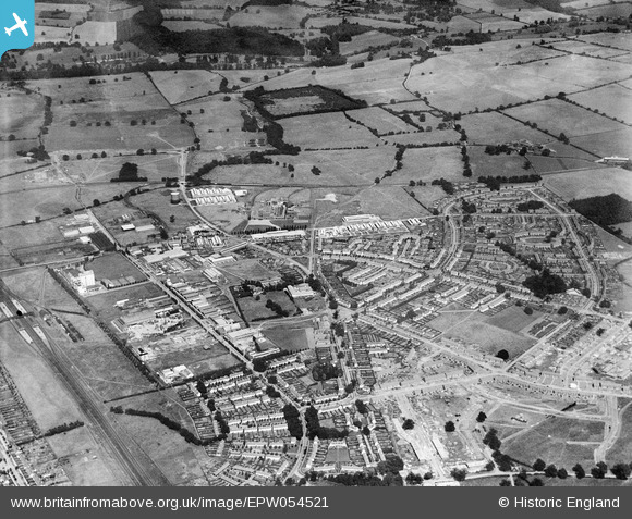
EPW054521 ENGLAND (1937). The residential and industrial area at Peartree, Welwyn Garden City, 1937
© Copyright OpenStreetMap contributors and licensed by the OpenStreetMap Foundation. 2025. Cartography is licensed as CC BY-SA.
Nearby Images (24)
Details
| Title | [EPW054521] The residential and industrial area at Peartree, Welwyn Garden City, 1937 |
| Reference | EPW054521 |
| Date | 30-July-1937 |
| Link | |
| Place name | WELWYN GARDEN CITY |
| Parish | |
| District | |
| Country | ENGLAND |
| Easting / Northing | 524623, 212731 |
| Longitude / Latitude | -0.19251992177663, 51.798872004635 |
| National Grid Reference | TL246127 |
Pins
Be the first to add a comment to this image!


![[EPW054521] The residential and industrial area at Peartree, Welwyn Garden City, 1937](http://britainfromabove.org.uk/sites/all/libraries/aerofilms-images/public/100x100/EPW/054/EPW054521.jpg)
![[EAW040872] Factories off Bridge Road East including the Barcleys Corset Factory, Welwyn Garden City, 1951. This image has been produced from a print marked by Aerofilms Ltd for photo editing.](http://britainfromabove.org.uk/sites/all/libraries/aerofilms-images/public/100x100/EAW/040/EAW040872.jpg)
![[EAW040874] Factories off Bridge Road East, Welwyn Garden City, 1951. This image has been produced from a print marked by Aerofilms Ltd for photo editing.](http://britainfromabove.org.uk/sites/all/libraries/aerofilms-images/public/100x100/EAW/040/EAW040874.jpg)
![[EAW040876] Factories off Bridge Road East including the Barcleys Corset Factory, Welwyn Garden City, 1951. This image has been produced from a print marked by Aerofilms Ltd for photo editing.](http://britainfromabove.org.uk/sites/all/libraries/aerofilms-images/public/100x100/EAW/040/EAW040876.jpg)
![[EAW040871] Factories off Bridge Road East including the Barcleys Corset Factory, Welwyn Garden City, 1951. This image was marked by Aerofilms Ltd for photo editing.](http://britainfromabove.org.uk/sites/all/libraries/aerofilms-images/public/100x100/EAW/040/EAW040871.jpg)
![[EAW016534] The Norton Grinding Wheel Co Ltd Works (site of), Welwyn Garden City, 1948. This image has been produced from a damaged negative.](http://britainfromabove.org.uk/sites/all/libraries/aerofilms-images/public/100x100/EAW/016/EAW016534.jpg)
![[EPW054520] The residential and industrial area at Peartree, Welwyn Garden City, 1937](http://britainfromabove.org.uk/sites/all/libraries/aerofilms-images/public/100x100/EPW/054/EPW054520.jpg)
![[EAW040873] Factories off Bridge Road East, Welwyn Garden City, 1951. This image has been produced from a print marked by Aerofilms Ltd for photo editing.](http://britainfromabove.org.uk/sites/all/libraries/aerofilms-images/public/100x100/EAW/040/EAW040873.jpg)
![[EAW040875] Factories off Bridge Road East including the Barcleys Corset Factory, Welwyn Garden City, 1951. This image has been produced from a print marked by Aerofilms Ltd for photo editing.](http://britainfromabove.org.uk/sites/all/libraries/aerofilms-images/public/100x100/EAW/040/EAW040875.jpg)
![[EAW016525] The Norton Grinding Wheel Co Ltd Works, Welwyn Garden City, 1948. This image has been produced from a print.](http://britainfromabove.org.uk/sites/all/libraries/aerofilms-images/public/100x100/EAW/016/EAW016525.jpg)
![[EAW040877] Factories off Bridge Road East, Welwyn Garden City, 1951. This image has been produced from a print.](http://britainfromabove.org.uk/sites/all/libraries/aerofilms-images/public/100x100/EAW/040/EAW040877.jpg)
![[EPW054492] The Norton Grinding Wheel Co Manufactory, Welwyn Garden City, 1937](http://britainfromabove.org.uk/sites/all/libraries/aerofilms-images/public/100x100/EPW/054/EPW054492.jpg)
![[EAW016536] Tewin Road and the Norton Grinding Wheel Co Ltd Works (site of), Welwyn Garden City, 1948. This image has been produced from a damaged negative.](http://britainfromabove.org.uk/sites/all/libraries/aerofilms-images/public/100x100/EAW/016/EAW016536.jpg)
![[EAW053106] The Norton Grinding Wheel Co Manufactory, Welwyn Garden City, 1954](http://britainfromabove.org.uk/sites/all/libraries/aerofilms-images/public/100x100/EAW/053/EAW053106.jpg)
![[EPW054499] The residential area at Peartree, Welwyn Garden City, 1937](http://britainfromabove.org.uk/sites/all/libraries/aerofilms-images/public/100x100/EPW/054/EPW054499.jpg)
![[EAW016523] The Norton Grinding Wheel Co Ltd Works, Welwyn Garden City, 1948. This image has been produced from a print.](http://britainfromabove.org.uk/sites/all/libraries/aerofilms-images/public/100x100/EAW/016/EAW016523.jpg)
![[EPW047352] The Shredded Wheat Factory and other industrial works near Broadwater Road, Welwyn Garden City, 1935](http://britainfromabove.org.uk/sites/all/libraries/aerofilms-images/public/100x100/EPW/047/EPW047352.jpg)
![[EAW016530] Bridge Road and the Norton Grinding Wheel Co Ltd Works (site of), Welwyn Garden City, 1948. This image has been produced from a damaged negative.](http://britainfromabove.org.uk/sites/all/libraries/aerofilms-images/public/100x100/EAW/016/EAW016530.jpg)
![[EAW016529] Bridge Road and the Norton Grinding Wheel Co Ltd Works (site of), Welwyn Garden City, 1948. This image has been produced from a damaged negative.](http://britainfromabove.org.uk/sites/all/libraries/aerofilms-images/public/100x100/EAW/016/EAW016529.jpg)
![[EAW016533] The Norton Grinding Wheel Co Ltd Works, Welwyn Garden City, 1948. This image has been produced from a damaged negative.](http://britainfromabove.org.uk/sites/all/libraries/aerofilms-images/public/100x100/EAW/016/EAW016533.jpg)
![[EPW047354] The Shredded Wheat Factory and other industrial works, Welwyn Garden City, 1935](http://britainfromabove.org.uk/sites/all/libraries/aerofilms-images/public/100x100/EPW/047/EPW047354.jpg)
![[EPW054541] The residential area surrounding Verulam Close, Cranborne Gardens and Shortlands Green, Peartree, 1937](http://britainfromabove.org.uk/sites/all/libraries/aerofilms-images/public/100x100/EPW/054/EPW054541.jpg)
![[EAW016531] The Norton Grinding Wheel Co Ltd Works (site of), Welwyn Garden City, 1948. This image has been produced from a damaged negative.](http://britainfromabove.org.uk/sites/all/libraries/aerofilms-images/public/100x100/EAW/016/EAW016531.jpg)
![[EPW054500] The Murphy Radio Ltd Manufactory, the Sectional Factory Units and the Norton Grinding Wheel Co Manufactory, Welwyn Garden City, 1937](http://britainfromabove.org.uk/sites/all/libraries/aerofilms-images/public/100x100/EPW/054/EPW054500.jpg)