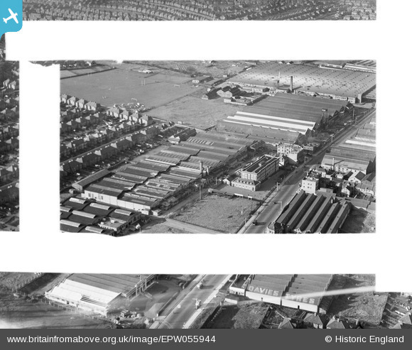
EPW055944 ENGLAND (1937). The Phoenix Telephone and Electric Co Works, Kingsbury, 1937. This image was marked by Aerofilms Ltd for photo editing.
© Copyright OpenStreetMap contributors and licensed by the OpenStreetMap Foundation. 2025. Cartography is licensed as CC BY-SA.
Nearby Images (40)
Details
| Title | [EPW055944] The Phoenix Telephone and Electric Co Works, Kingsbury, 1937. This image was marked by Aerofilms Ltd for photo editing. |
| Reference | EPW055944 |
| Date | 9-November-1937 |
| Link | |
| Place name | KINGSBURY |
| Parish | |
| District | |
| Country | ENGLAND |
| Easting / Northing | 520759, 189499 |
| Longitude / Latitude | -0.25657728700184, 51.590910173267 |
| National Grid Reference | TQ208895 |
Pins
 Class31 |
Tuesday 28th of April 2015 08:51:44 AM |


![[EPW055944] The Phoenix Telephone and Electric Co Works, Kingsbury, 1937. This image was marked by Aerofilms Ltd for photo editing.](http://britainfromabove.org.uk/sites/all/libraries/aerofilms-images/public/100x100/EPW/055/EPW055944.jpg)
![[EPW055950] Works off the Edgware Road including the Phoenix Telephone and Electric Co Works, Kingsbury, 1937](http://britainfromabove.org.uk/sites/all/libraries/aerofilms-images/public/100x100/EPW/055/EPW055950.jpg)
![[EPW055947] Works off the Edgware Road including the Phoenix Telephone and Electric Co Works, Kingsbury, 1937](http://britainfromabove.org.uk/sites/all/libraries/aerofilms-images/public/100x100/EPW/055/EPW055947.jpg)
![[EPW055943] Works off the Edgware Road including the Phoenix Telephone and Electric Co Works, Kingsbury, 1937](http://britainfromabove.org.uk/sites/all/libraries/aerofilms-images/public/100x100/EPW/055/EPW055943.jpg)
![[EPW055952] Works off the Edgware Road including the Phoenix Telephone and Electric Co Works and Davies Tyres Works, Kingsbury, 1937](http://britainfromabove.org.uk/sites/all/libraries/aerofilms-images/public/100x100/EPW/055/EPW055952.jpg)
![[EPW055949] The Phoenix Telephone and Electric Co Works and environs, Kingsbury, 1937](http://britainfromabove.org.uk/sites/all/libraries/aerofilms-images/public/100x100/EPW/055/EPW055949.jpg)
![[EPW013752] Factories and school building (former AIRCO offices) on the Hyde (Edgware Road), Kingsbury, 1928. This image has been produced from a print.](http://britainfromabove.org.uk/sites/all/libraries/aerofilms-images/public/100x100/EPW/013/EPW013752.jpg)
![[EPW055951] The Phoenix Telephone and Electric Co Works and environs, Kingsbury, 1937](http://britainfromabove.org.uk/sites/all/libraries/aerofilms-images/public/100x100/EPW/055/EPW055951.jpg)
![[EPW055946] The Phoenix Telephone and Electric Co Works and environs, Kingsbury, 1937](http://britainfromabove.org.uk/sites/all/libraries/aerofilms-images/public/100x100/EPW/055/EPW055946.jpg)
![[EPW012748] Factories on the Edgware Road, Colindale, 1925](http://britainfromabove.org.uk/sites/all/libraries/aerofilms-images/public/100x100/EPW/012/EPW012748.jpg)
![[EPW055948] The Daimler Co Repair and Hiring Depot and the Phoenix Telephone and Electric Co Works, Queensbury, 1937](http://britainfromabove.org.uk/sites/all/libraries/aerofilms-images/public/100x100/EPW/055/EPW055948.jpg)
![[EPW032156] Davies Tyre Works and Edgware Road, Colindale, 1930](http://britainfromabove.org.uk/sites/all/libraries/aerofilms-images/public/100x100/EPW/032/EPW032156.jpg)
![[EPW032159] Davies Tyre Works and environs, Colindale, 1930](http://britainfromabove.org.uk/sites/all/libraries/aerofilms-images/public/100x100/EPW/032/EPW032159.jpg)
![[EPW055945] The Daimler Co Repair and Hiring Depot and surrounding works on Edgware Road, Queensbury, 1937](http://britainfromabove.org.uk/sites/all/libraries/aerofilms-images/public/100x100/EPW/055/EPW055945.jpg)
![[EPW020810] Desoutter Brothers Ltd Electrical Tool Works, Colindale, 1928](http://britainfromabove.org.uk/sites/all/libraries/aerofilms-images/public/100x100/EPW/020/EPW020810.jpg)
![[EPW024932] The Safetex Glass Works, Colindale, 1928](http://britainfromabove.org.uk/sites/all/libraries/aerofilms-images/public/100x100/EPW/024/EPW024932.jpg)
![[EPW032157] Davies Tyre Works, Colindale, 1930](http://britainfromabove.org.uk/sites/all/libraries/aerofilms-images/public/100x100/EPW/032/EPW032157.jpg)
![[EPW032158] Davies Tyre Works and Edgware Road, Colindale, 1930](http://britainfromabove.org.uk/sites/all/libraries/aerofilms-images/public/100x100/EPW/032/EPW032158.jpg)
![[EPW024931] Aerofilms Ltd on Colindale Avenue, Colindale, 1928](http://britainfromabove.org.uk/sites/all/libraries/aerofilms-images/public/100x100/EPW/024/EPW024931.jpg)
![[EPW021145] Desoutter Brothers Electrical Tool Works, The Hyde, 1928](http://britainfromabove.org.uk/sites/all/libraries/aerofilms-images/public/100x100/EPW/021/EPW021145.jpg)
![[EPW021147] Desoutter Brothers Electrical Tool Works, The Hyde, 1928](http://britainfromabove.org.uk/sites/all/libraries/aerofilms-images/public/100x100/EPW/021/EPW021147.jpg)
![[EPW021144] Desoutter Brothers Electrical Tool Works and Beardmore Motor Works, The Hyde, 1928](http://britainfromabove.org.uk/sites/all/libraries/aerofilms-images/public/100x100/EPW/021/EPW021144.jpg)
![[EPW021146] Desoutter Brothers Electrical Tool Works and Beardmore Motor Works, The Hyde, 1928](http://britainfromabove.org.uk/sites/all/libraries/aerofilms-images/public/100x100/EPW/021/EPW021146.jpg)
![[EPW020686] Desoutter Brothers Ltd and the Beardmore Motor Works, The Hyde, 1928](http://britainfromabove.org.uk/sites/all/libraries/aerofilms-images/public/100x100/EPW/020/EPW020686.jpg)
![[EPW020689] Desoutter Brothers Ltd, The Hyde, 1928](http://britainfromabove.org.uk/sites/all/libraries/aerofilms-images/public/100x100/EPW/020/EPW020689.jpg)
![[EPW020812] Desoutter Brothers Ltd Electrical Tool Works, Colindale, 1928](http://britainfromabove.org.uk/sites/all/libraries/aerofilms-images/public/100x100/EPW/020/EPW020812.jpg)
![[EPW034540] Aerofilms Ltd on Colindale Avenue, Colindale, 1930](http://britainfromabove.org.uk/sites/all/libraries/aerofilms-images/public/100x100/EPW/034/EPW034540.jpg)
![[EPR000505] The Desoutter Bros Ltd Electrical Tool Works, The Hyde, 1935. This image was marked by Aero Pictorial Ltd for photo editing.](http://britainfromabove.org.uk/sites/all/libraries/aerofilms-images/public/100x100/EPR/000/EPR000505.jpg)
![[EPW020683] Desoutter Brothers Ltd, The Hyde, 1928](http://britainfromabove.org.uk/sites/all/libraries/aerofilms-images/public/100x100/EPW/020/EPW020683.jpg)
![[EPW020811] Desoutter Brothers Ltd Electrical Tool Works, Colindale, 1928](http://britainfromabove.org.uk/sites/all/libraries/aerofilms-images/public/100x100/EPW/020/EPW020811.jpg)
![[EPW031584] Davies Tyre Works and environs, Colindale, 1930](http://britainfromabove.org.uk/sites/all/libraries/aerofilms-images/public/100x100/EPW/031/EPW031584.jpg)
![[EPW013751] Desoutter Brothers Ltd Electrical Tool Works, Kingsbury, 1928. This image has been produced from a print.](http://britainfromabove.org.uk/sites/all/libraries/aerofilms-images/public/100x100/EPW/013/EPW013751.jpg)
![[EPW020688] Desoutter Brothers Ltd and the Beardmore Motor Works, The Hyde, 1928](http://britainfromabove.org.uk/sites/all/libraries/aerofilms-images/public/100x100/EPW/020/EPW020688.jpg)
![[EPW020685] Desoutter Brothers Ltd and the Beardmore Motor Works, The Hyde, 1928](http://britainfromabove.org.uk/sites/all/libraries/aerofilms-images/public/100x100/EPW/020/EPW020685.jpg)
![[EPW020844] Aerofilms Ltd offices on Colindale Avenue, Hendon, 1928](http://britainfromabove.org.uk/sites/all/libraries/aerofilms-images/public/100x100/EPW/020/EPW020844.jpg)
![[EPW020690] Desoutter Brothers Ltd and the Beardmore Motor Works, The Hyde, 1928](http://britainfromabove.org.uk/sites/all/libraries/aerofilms-images/public/100x100/EPW/020/EPW020690.jpg)
![[EPW020684] Desoutter Brothers Ltd, The Hyde, 1928](http://britainfromabove.org.uk/sites/all/libraries/aerofilms-images/public/100x100/EPW/020/EPW020684.jpg)
![[EPW020687] Desoutter Brothers Ltd and the Beardmore Motor Works, The Hyde, 1928](http://britainfromabove.org.uk/sites/all/libraries/aerofilms-images/public/100x100/EPW/020/EPW020687.jpg)
![[EPW025885] Everett, Edgcumbe and Co Electrical Instrument Works, Colindale, 1929. This image has been produced from a print.](http://britainfromabove.org.uk/sites/all/libraries/aerofilms-images/public/100x100/EPW/025/EPW025885.jpg)
![[EPW015610] Motor Works, hospital and Hendon Aerodrome, Colindale, 1926](http://britainfromabove.org.uk/sites/all/libraries/aerofilms-images/public/100x100/EPW/015/EPW015610.jpg)