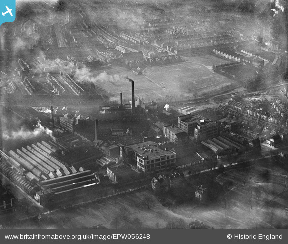
EPW056248 ENGLAND (1938). Eastman's Dyeing and environs, Acton, 1938
© Copyright OpenStreetMap contributors and licensed by the OpenStreetMap Foundation. 2025. Cartography is licensed as CC BY-SA.
Nearby Images (28)
Details
| Title | [EPW056248] Eastman's Dyeing and environs, Acton, 1938 |
| Reference | EPW056248 |
| Date | 17-January-1938 |
| Link | |
| Place name | ACTON |
| Parish | |
| District | |
| Country | ENGLAND |
| Easting / Northing | 520856, 179918 |
| Longitude / Latitude | -0.25846952386233, 51.504772775497 |
| National Grid Reference | TQ209799 |
Pins
Be the first to add a comment to this image!


![[EPW056248] Eastman's Dyeing and environs, Acton, 1938](http://britainfromabove.org.uk/sites/all/libraries/aerofilms-images/public/100x100/EPW/056/EPW056248.jpg)
![[EPW056296] The Eastman and Son Cleaning and Dyeing Works and environs, Acton, 1938](http://britainfromabove.org.uk/sites/all/libraries/aerofilms-images/public/100x100/EPW/056/EPW056296.jpg)
![[EPW056293] The Eastman and Son Cleaning and Dyeing Works and environs, Acton, 1938](http://britainfromabove.org.uk/sites/all/libraries/aerofilms-images/public/100x100/EPW/056/EPW056293.jpg)
![[EPW056297] The Eastman and Son Cleaning and Dyeing Works, Acton, 1938](http://britainfromabove.org.uk/sites/all/libraries/aerofilms-images/public/100x100/EPW/056/EPW056297.jpg)
![[EPW056299] The Eastman and Son Cleaning and Dyeing Works and environs, Acton, 1938](http://britainfromabove.org.uk/sites/all/libraries/aerofilms-images/public/100x100/EPW/056/EPW056299.jpg)
![[EPW056244] Eastman's Dyeing and Cleaning Works and environs, Acton, 1938](http://britainfromabove.org.uk/sites/all/libraries/aerofilms-images/public/100x100/EPW/056/EPW056244.jpg)
![[EPW056295] The Eastman and Son Cleaning and Dyeing Works and environs, Acton, 1938](http://britainfromabove.org.uk/sites/all/libraries/aerofilms-images/public/100x100/EPW/056/EPW056295.jpg)
![[EPW056245] Eastman's Dyeing and Cleaning Works and environs, Acton, 1938](http://britainfromabove.org.uk/sites/all/libraries/aerofilms-images/public/100x100/EPW/056/EPW056245.jpg)
![[EPW056294] The Eastman and Son Cleaning and Dyeing Works and environs, Acton, 1938](http://britainfromabove.org.uk/sites/all/libraries/aerofilms-images/public/100x100/EPW/056/EPW056294.jpg)
![[EPW056292] The Eastman and Son Cleaning and Dyeing Works, Acton, 1938](http://britainfromabove.org.uk/sites/all/libraries/aerofilms-images/public/100x100/EPW/056/EPW056292.jpg)
![[EPW056249] Eastman's Dyeing and Cleaning Works and environs, Acton, 1938](http://britainfromabove.org.uk/sites/all/libraries/aerofilms-images/public/100x100/EPW/056/EPW056249.jpg)
![[EPW056298] The Eastman and Son Cleaning and Dyeing Works and environs, Acton, 1938](http://britainfromabove.org.uk/sites/all/libraries/aerofilms-images/public/100x100/EPW/056/EPW056298.jpg)
![[EPW056291] The Eastman and Son Cleaning and Dyeing Works and environs, Acton, 1938](http://britainfromabove.org.uk/sites/all/libraries/aerofilms-images/public/100x100/EPW/056/EPW056291.jpg)
![[EPW056300] The Eastman and Son Cleaning and Dyeing Works and environs, Acton, 1938](http://britainfromabove.org.uk/sites/all/libraries/aerofilms-images/public/100x100/EPW/056/EPW056300.jpg)
![[EPW056250] Eastman's Dyeing and Cleaning Works and environs, Acton, 1938](http://britainfromabove.org.uk/sites/all/libraries/aerofilms-images/public/100x100/EPW/056/EPW056250.jpg)
![[EPW056246] Eastman's Dyeing and Cleaning Works, Acton, 1938](http://britainfromabove.org.uk/sites/all/libraries/aerofilms-images/public/100x100/EPW/056/EPW056246.jpg)
![[EPW056247] Eastman's Dyeing and Cleaning Works, Acton Park and environs, Acton, 1938](http://britainfromabove.org.uk/sites/all/libraries/aerofilms-images/public/100x100/EPW/056/EPW056247.jpg)
![[EPW007147] Factories including Eastmans Cleaning and Dyeing Works and environs, Acton, 1921](http://britainfromabove.org.uk/sites/all/libraries/aerofilms-images/public/100x100/EPW/007/EPW007147.jpg)
![[EPW044577] The D. Napier & Son Ltd Engineering Works and the Eastman and Son Dyeing and Cleaning Works, Acton, 1934](http://britainfromabove.org.uk/sites/all/libraries/aerofilms-images/public/100x100/EPW/044/EPW044577.jpg)
![[EPW006169] Engineering Works beside Action Park, Acton, from the south-west, 1921](http://britainfromabove.org.uk/sites/all/libraries/aerofilms-images/public/100x100/EPW/006/EPW006169.jpg)
![[EPW044640] The D. Napier & Son Ltd Engineering Works and the Eastman and Son Dyeing and Cleaning Works, Acton, 1934](http://britainfromabove.org.uk/sites/all/libraries/aerofilms-images/public/100x100/EPW/044/EPW044640.jpg)
![[EPW044639] The D. Napier & Son Ltd Engineering Works and the Eastman and Son Dyeing and Cleaning Works, Acton, 1934](http://britainfromabove.org.uk/sites/all/libraries/aerofilms-images/public/100x100/EPW/044/EPW044639.jpg)
![[EPW006184] Napier Motor Car Engineering Works and Eastmans Dyeing and Cleaning Works, Acton, 1921](http://britainfromabove.org.uk/sites/all/libraries/aerofilms-images/public/100x100/EPW/006/EPW006184.jpg)
![[EPW044643] The D. Napier & Son Ltd Engineering Works and the Eastman and Son Dyeing and Cleaning Works, Acton, 1934](http://britainfromabove.org.uk/sites/all/libraries/aerofilms-images/public/100x100/EPW/044/EPW044643.jpg)
![[EPW044578] The D. Napier & Son Ltd Engineering Works and the Eastman and Son Dyeing and Cleaning Works, Acton, 1934](http://britainfromabove.org.uk/sites/all/libraries/aerofilms-images/public/100x100/EPW/044/EPW044578.jpg)
![[EPW044642] The D. Napier & Son Ltd Engineering Works and the Eastman and Son Dyeing and Cleaning Works, Acton, 1934](http://britainfromabove.org.uk/sites/all/libraries/aerofilms-images/public/100x100/EPW/044/EPW044642.jpg)
![[EPW044641] The D. Napier & Son Ltd Engineering Works and the Eastman and Son Dyeing and Cleaning Works, Acton, 1934](http://britainfromabove.org.uk/sites/all/libraries/aerofilms-images/public/100x100/EPW/044/EPW044641.jpg)
![[EPW010694] Acton Park and The Ministry of Pensions Building, Acton, from the west, 1924](http://britainfromabove.org.uk/sites/all/libraries/aerofilms-images/public/100x100/EPW/010/EPW010694.jpg)