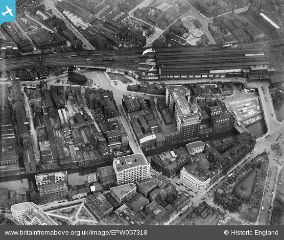
EPW057318 ENGLAND (1938). Blackfriars Street, the Telephone Exchange (Dial House), Exchange Station and environs, Salford, 1938
© Copyright OpenStreetMap contributors and licensed by the OpenStreetMap Foundation. 2024. Cartography is licensed as CC BY-SA.
Nearby Images (14)
Details
| Title | [EPW057318] Blackfriars Street, the Telephone Exchange (Dial House), Exchange Station and environs, Salford, 1938 |
| Reference | EPW057318 |
| Date | 3-June-1938 |
| Link | |
| Place name | SALFORD |
| Parish | |
| District | |
| Country | ENGLAND |
| Easting / Northing | 383616, 398663 |
| Longitude / Latitude | -2.2469301505591, 53.484177969484 |
| National Grid Reference | SJ836987 |
Pins
 Industrygeek |
Monday 18th of April 2016 10:09:15 PM | |
 Industrygeek |
Monday 18th of April 2016 10:01:34 PM | |
 Industrygeek |
Monday 18th of April 2016 09:56:54 PM | |
 totoro |
Wednesday 14th of August 2013 07:01:57 PM | |
 totoro |
Wednesday 14th of August 2013 06:55:58 PM | |
 totoro |
Wednesday 14th of August 2013 06:40:40 PM | |
 totoro |
Wednesday 14th of August 2013 06:35:57 PM | |
 totoro |
Wednesday 14th of August 2013 06:27:18 PM | |
 totoro |
Wednesday 14th of August 2013 06:19:42 PM | |
 totoro |
Wednesday 14th of August 2013 06:12:02 PM | |
 totoro |
Wednesday 14th of August 2013 06:11:34 PM | |
 totoro |
Wednesday 14th of August 2013 06:10:09 PM | |
 totoro |
Wednesday 14th of August 2013 06:09:30 PM | |
 totoro |
Wednesday 14th of August 2013 06:08:42 PM | |
 totoro |
Wednesday 14th of August 2013 06:07:59 PM | |
 totoro |
Wednesday 14th of August 2013 06:07:23 PM | |
 totoro |
Wednesday 14th of August 2013 06:06:01 PM | |
 totoro |
Wednesday 14th of August 2013 06:05:21 PM | |
 totoro |
Wednesday 14th of August 2013 06:04:51 PM | |
 totoro |
Wednesday 14th of August 2013 06:03:09 PM | |
 totoro |
Wednesday 14th of August 2013 06:02:37 PM | |
 totoro |
Wednesday 14th of August 2013 05:59:49 PM | |
 totoro |
Wednesday 14th of August 2013 05:58:26 PM | |
 totoro |
Wednesday 14th of August 2013 05:57:00 PM |


![[EPW057318] Blackfriars Street, the Telephone Exchange (Dial House), Exchange Station and environs, Salford, 1938](http://britainfromabove.org.uk/sites/all/libraries/aerofilms-images/public/100x100/EPW/057/EPW057318.jpg)
![[EPW057317] The Telephone Exchange (Dial House), Exchange Station and environs, Salford, 1938](http://britainfromabove.org.uk/sites/all/libraries/aerofilms-images/public/100x100/EPW/057/EPW057317.jpg)
![[EPW057315] Blackfriars Street and environs, Salford, 1938. This image has been affected by flare.](http://britainfromabove.org.uk/sites/all/libraries/aerofilms-images/public/100x100/EPW/057/EPW057315.jpg)
![[EPW057694] Chapel Street, Blackfriars Street, the Telephone Exchange (Dial House) and environs, Salford, 1938](http://britainfromabove.org.uk/sites/all/libraries/aerofilms-images/public/100x100/EPW/057/EPW057694.jpg)
![[EPW057695] Blackfriars Street and environs, Salford, 1938](http://britainfromabove.org.uk/sites/all/libraries/aerofilms-images/public/100x100/EPW/057/EPW057695.jpg)
![[EPW057314] The River Irwell, the Telephone Exchange (Dial House) and environs, Salford, 1938](http://britainfromabove.org.uk/sites/all/libraries/aerofilms-images/public/100x100/EPW/057/EPW057314.jpg)
![[EPW057692] Chapel Street, Blackfriars Street, the Telephone Exchange (Dial House) and environs, Salford, 1938](http://britainfromabove.org.uk/sites/all/libraries/aerofilms-images/public/100x100/EPW/057/EPW057692.jpg)
![[EPW057693] Blackfriars Street and environs, Salford, 1938](http://britainfromabove.org.uk/sites/all/libraries/aerofilms-images/public/100x100/EPW/057/EPW057693.jpg)
![[EPW057316] Blackfriars Street, the Telephone Exchange (Dial House) and environs, Manchester, 1938](http://britainfromabove.org.uk/sites/all/libraries/aerofilms-images/public/100x100/EPW/057/EPW057316.jpg)
![[EPW019091] Victoria Buildings on St Mary's Gate, Manchester, 1927. This image has been produced from a copy-negative.](http://britainfromabove.org.uk/sites/all/libraries/aerofilms-images/public/100x100/EPW/019/EPW019091.jpg)
![[EAW030343] The D. C. Thomson and Co Printing and Publishing Works, Salford, 1950. This image was marked by Aerofilms Ltd for photo editing.](http://britainfromabove.org.uk/sites/all/libraries/aerofilms-images/public/100x100/EAW/030/EAW030343.jpg)
![[EAW030345] The D. C. Thomson and Co Printing and Publishing Works, Salford, 1950. This image was marked by Aerofilms Ltd for photo editing.](http://britainfromabove.org.uk/sites/all/libraries/aerofilms-images/public/100x100/EAW/030/EAW030345.jpg)
![[EAW030341] The D. C. Thomson and Co Printing and Publishing Works, Salford, 1950. This image was marked by Aerofilms Ltd for photo editing.](http://britainfromabove.org.uk/sites/all/libraries/aerofilms-images/public/100x100/EAW/030/EAW030341.jpg)
![[EAW016004] The Royal Exchange, St Ann Street and environs, Manchester, 1948. This image has been produced from a print.](http://britainfromabove.org.uk/sites/all/libraries/aerofilms-images/public/100x100/EAW/016/EAW016004.jpg)
