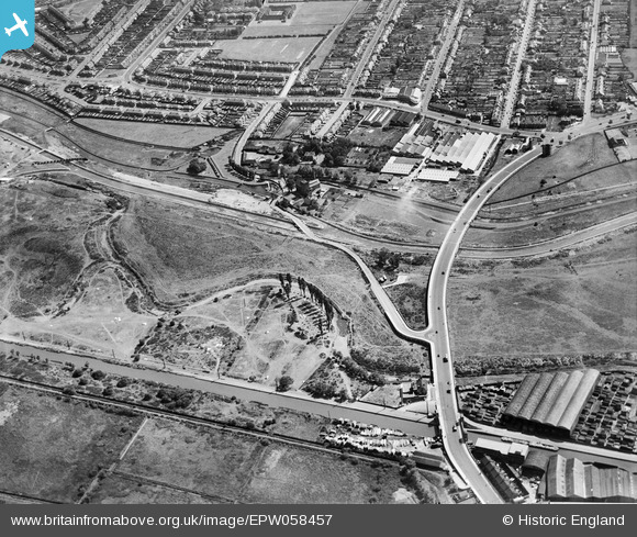
EPW058457 ENGLAND (1938). The North Circular Road Crossing the River Lea, Edmonton, 1938
© Copyright OpenStreetMap contributors and licensed by the OpenStreetMap Foundation. 2025. Cartography is licensed as CC BY-SA.
Nearby Images (28)
Details
| Title | [EPW058457] The North Circular Road Crossing the River Lea, Edmonton, 1938 |
| Reference | EPW058457 |
| Date | 3-August-1938 |
| Link | |
| Place name | EDMONTON |
| Parish | |
| District | |
| Country | ENGLAND |
| Easting / Northing | 536153, 192425 |
| Longitude / Latitude | -0.033327742223933, 51.613696097956 |
| National Grid Reference | TQ362924 |
Pins
Be the first to add a comment to this image!


![[EPW058457] The North Circular Road Crossing the River Lea, Edmonton, 1938](http://britainfromabove.org.uk/sites/all/libraries/aerofilms-images/public/100x100/EPW/058/EPW058457.jpg)
![[EPW058467] The River Lea, Chingford Mill Pumping Station and environs, Edmonton, 1938](http://britainfromabove.org.uk/sites/all/libraries/aerofilms-images/public/100x100/EPW/058/EPW058467.jpg)
![[EPW052271] The junction of Lower Hall Lane and the North Circular Road, Edmonton, 1936. This image has been produced from a damaged negative.](http://britainfromabove.org.uk/sites/all/libraries/aerofilms-images/public/100x100/EPW/052/EPW052271.jpg)
![[EPW056816] The junction of the North Circular Road and Lower Hall Lane, Edmonton, 1938](http://britainfromabove.org.uk/sites/all/libraries/aerofilms-images/public/100x100/EPW/056/EPW056816.jpg)
![[EPW053836] The North Circular Road and the River Lea, Edmonton, 1937](http://britainfromabove.org.uk/sites/all/libraries/aerofilms-images/public/100x100/EPW/053/EPW053836.jpg)
![[EPW056823] The junction of Lower Hall Lane and the North Circular Road, Edmonton, 1938](http://britainfromabove.org.uk/sites/all/libraries/aerofilms-images/public/100x100/EPW/056/EPW056823.jpg)
![[EPW056320] The River Lea at the southern end of the site of the William Girling Reservoir, Edmonton, 1938](http://britainfromabove.org.uk/sites/all/libraries/aerofilms-images/public/100x100/EPW/056/EPW056320.jpg)
![[EPW055981] The William Girling Reservoir under construction at Chingford Mill Pumping Station, Edmonton, 1937](http://britainfromabove.org.uk/sites/all/libraries/aerofilms-images/public/100x100/EPW/055/EPW055981.jpg)
![[EPW050859] The River Lea at Lower Hall Lane, Edmonton, 1936](http://britainfromabove.org.uk/sites/all/libraries/aerofilms-images/public/100x100/EPW/050/EPW050859.jpg)
![[EPW056321] The junction of the North Circular Road and Lower Hall Lane, Edmonton, 1938](http://britainfromabove.org.uk/sites/all/libraries/aerofilms-images/public/100x100/EPW/056/EPW056321.jpg)
![[EPW052287] The site of the southern end of the William Girling Reservoir showing preliminary construction works, Edmonton, 1936. This image has been produced from a damaged negative.](http://britainfromabove.org.uk/sites/all/libraries/aerofilms-images/public/100x100/EPW/052/EPW052287.jpg)
![[EPW052282] The junction of Lower Hall Lane and the North Circular Road, Edmonton, 1936. This image has been produced from a damaged negative.](http://britainfromabove.org.uk/sites/all/libraries/aerofilms-images/public/100x100/EPW/052/EPW052282.jpg)
![[EPW055980] The William Girling Reservoir under construction at Chingford Mill Pumping Station, Edmonton, 1937](http://britainfromabove.org.uk/sites/all/libraries/aerofilms-images/public/100x100/EPW/055/EPW055980.jpg)
![[EPW056818] The junction of Lower Hall Lane and the North Circular Road, Edmonton, 1938](http://britainfromabove.org.uk/sites/all/libraries/aerofilms-images/public/100x100/EPW/056/EPW056818.jpg)
![[EPW053837] The North Circular Road and the River Lea, Edmonton, 1937](http://britainfromabove.org.uk/sites/all/libraries/aerofilms-images/public/100x100/EPW/053/EPW053837.jpg)
![[EPW018656] The Lea Valley Viaduct and environs, Chingford, 1927](http://britainfromabove.org.uk/sites/all/libraries/aerofilms-images/public/100x100/EPW/018/EPW018656.jpg)
![[EAW037672] The London Rubber Company (British Latex Products) Factory and the Cork Manufacturing Co Ltd Langite Works off Hall Lane, Chingford, 1951. This image has been produced from a print marked by Aerofilms Ltd for photo editing.](http://britainfromabove.org.uk/sites/all/libraries/aerofilms-images/public/100x100/EAW/037/EAW037672.jpg)
![[EAW037671] The London Rubber Company (British Latex Products) Factory, Flexo Plywood Works and the Cork Manufacturing Co Ltd Langite Works off Hall Lane, Chingford, 1951. This image has been produced from a print marked by Aerofilms Ltd for photo editing](http://britainfromabove.org.uk/sites/all/libraries/aerofilms-images/public/100x100/EAW/037/EAW037671.jpg)
![[EAW037675] The London Rubber Company (British Latex Products) Factory and the Cork Manufacturing Co Ltd Langite Works off Hall Lane, Chingford, 1951. This image has been produced from a print marked by Aerofilms Ltd for photo editing.](http://britainfromabove.org.uk/sites/all/libraries/aerofilms-images/public/100x100/EAW/037/EAW037675.jpg)
![[EPW049529] The Sparklet Works and other industrial buildings along the North Circular Road , Upper Edmonton, 1935](http://britainfromabove.org.uk/sites/all/libraries/aerofilms-images/public/100x100/EPW/049/EPW049529.jpg)
![[EAW037670] The London Rubber Company (British Latex Products) Factory, Flexo Plywood Works and the Cork Manufacturing Co Ltd Langite Works off Hall Lane, Chingford, 1951. This image has been produced from a print marked by Aerofilms Ltd for photo editing](http://britainfromabove.org.uk/sites/all/libraries/aerofilms-images/public/100x100/EAW/037/EAW037670.jpg)
![[EPW049703] The junction of Lower Hall Lane and the North Circular Road and environs, Edmonton, 1936](http://britainfromabove.org.uk/sites/all/libraries/aerofilms-images/public/100x100/EPW/049/EPW049703.jpg)
![[EPW060635] Chingford Mill Pumping Station and the William Girling Reservoir under construction, Edmonton, 1939](http://britainfromabove.org.uk/sites/all/libraries/aerofilms-images/public/100x100/EPW/060/EPW060635.jpg)
![[EAW037673] The London Rubber Company (British Latex Products) Factory and the Cork Manufacturing Co Ltd Langite Works off Hall Lane, Chingford, 1951. This image has been produced from a print marked by Aerofilms Ltd for photo editing.](http://britainfromabove.org.uk/sites/all/libraries/aerofilms-images/public/100x100/EAW/037/EAW037673.jpg)
![[EPW018565] Cook's Ferry Public House and the Lea Valley Viaduct and environs, Edmonton, 1927](http://britainfromabove.org.uk/sites/all/libraries/aerofilms-images/public/100x100/EPW/018/EPW018565.jpg)
![[EPW018561] The Lea Valley Viaduct, Chingford, 1927](http://britainfromabove.org.uk/sites/all/libraries/aerofilms-images/public/100x100/EPW/018/EPW018561.jpg)
![[EPW018567] Cook's Ferry Public House and the Lea Valley Viaduct and environs, Edmonton, 1927](http://britainfromabove.org.uk/sites/all/libraries/aerofilms-images/public/100x100/EPW/018/EPW018567.jpg)
![[EPW018563] The Lea Valley Viaduct, Chingford, 1927](http://britainfromabove.org.uk/sites/all/libraries/aerofilms-images/public/100x100/EPW/018/EPW018563.jpg)