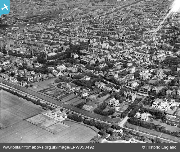
EPW058492 ENGLAND (1938). Rotten Row and the town, Southport, from the west, 1938
© Copyright OpenStreetMap contributors and licensed by the OpenStreetMap Foundation. 2025. Cartography is licensed as CC BY-SA.
Nearby Images (10)
Details
| Title | [EPW058492] Rotten Row and the town, Southport, from the west, 1938 |
| Reference | EPW058492 |
| Date | 26-July-1938 |
| Link | |
| Place name | SOUTHPORT |
| Parish | |
| District | |
| Country | ENGLAND |
| Easting / Northing | 332843, 416713 |
| Longitude / Latitude | -3.0159499179776, 53.642380531787 |
| National Grid Reference | SD328167 |
Pins
 Mark Farrar |
Sunday 7th of August 2016 07:11:19 AM | |
 Chris Willis |
Thursday 25th of February 2016 05:04:44 PM | |
 Chris Willis |
Thursday 25th of February 2016 04:59:05 PM | |
 Chris Willis |
Thursday 25th of February 2016 04:53:01 PM | |
 wadey |
Saturday 6th of December 2014 10:27:22 PM | |
 wadey |
Saturday 6th of December 2014 10:26:16 PM | |
 wadey |
Saturday 6th of December 2014 10:23:47 PM | |
 wadey |
Saturday 6th of December 2014 10:23:13 PM | |
 wadey |
Saturday 6th of December 2014 10:22:13 PM | |
 wadey |
Saturday 6th of December 2014 10:21:21 PM | |
 wadey |
Saturday 6th of December 2014 10:13:04 PM |


![[EPW058492] Rotten Row and the town, Southport, from the west, 1938](http://britainfromabove.org.uk/sites/all/libraries/aerofilms-images/public/100x100/EPW/058/EPW058492.jpg)
![[EAW010143] Southport, the Flower Show in Victoria Park, 1947. This image was marked by Aerofilms Ltd for photo editing.](http://britainfromabove.org.uk/sites/all/libraries/aerofilms-images/public/100x100/EAW/010/EAW010143.jpg)
![[EAW010145] Southport, the Flower Show in Victoria Park, 1947. This image was marked by Aerofilms Ltd for photo editing.](http://britainfromabove.org.uk/sites/all/libraries/aerofilms-images/public/100x100/EAW/010/EAW010145.jpg)
![[EAW010141] Southport, the Flower Show in Victoria Park, 1947. This image was marked by Aerofilms Ltd for photo editing.](http://britainfromabove.org.uk/sites/all/libraries/aerofilms-images/public/100x100/EAW/010/EAW010141.jpg)
![[EPW016820] The Southport Flower Show at Victoria Park, Southport, 1926](http://britainfromabove.org.uk/sites/all/libraries/aerofilms-images/public/100x100/EPW/016/EPW016820.jpg)
![[EAW010146] Southport, the Flower Show in Victoria Park, 1947. This image was marked by Aerofilms Ltd for photo editing.](http://britainfromabove.org.uk/sites/all/libraries/aerofilms-images/public/100x100/EAW/010/EAW010146.jpg)
![[EPW058489] Victoria Park and environs, Southport, 1938](http://britainfromabove.org.uk/sites/all/libraries/aerofilms-images/public/100x100/EPW/058/EPW058489.jpg)
![[EPW016824] The Southport Flower Show at Victoria Park, Southport, 1926](http://britainfromabove.org.uk/sites/all/libraries/aerofilms-images/public/100x100/EPW/016/EPW016824.jpg)
![[EAW010140] Southport, the Flower Show in Victoria Park, from the south-west, 1947. This image was marked by Aerofilms Ltd for photo editing.](http://britainfromabove.org.uk/sites/all/libraries/aerofilms-images/public/100x100/EAW/010/EAW010140.jpg)
![[EAW010139] Southport, the Flower Show in Victoria Park, 1947](http://britainfromabove.org.uk/sites/all/libraries/aerofilms-images/public/100x100/EAW/010/EAW010139.jpg)