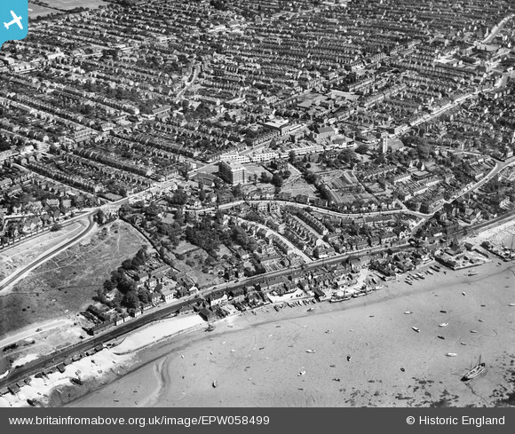
EPW058499 ENGLAND (1938). Leigh Park Road and environs, Leigh-on-Sea, 1938
© Copyright OpenStreetMap contributors and licensed by the OpenStreetMap Foundation. 2024. Cartography is licensed as CC BY-SA.
Nearby Images (14)
Details
| Title | [EPW058499] Leigh Park Road and environs, Leigh-on-Sea, 1938 |
| Reference | EPW058499 |
| Date | 3-August-1938 |
| Link | |
| Place name | LEIGH-ON-SEA |
| Parish | LEIGH-ON-SEA |
| District | |
| Country | ENGLAND |
| Easting / Northing | 583895, 185846 |
| Longitude / Latitude | 0.65214750159629, 51.541029502306 |
| National Grid Reference | TQ839858 |
Pins
 JonB |
Sunday 18th of August 2013 09:05:13 PM | |
 JonB |
Sunday 18th of August 2013 08:59:23 PM |


![[EPW058499] Leigh Park Road and environs, Leigh-on-Sea, 1938](http://britainfromabove.org.uk/sites/all/libraries/aerofilms-images/public/100x100/EPW/058/EPW058499.jpg)
![[EPW037013] Wharfage off High Street and Hadleigh Road, Leigh-on-Sea, 1931](http://britainfromabove.org.uk/sites/all/libraries/aerofilms-images/public/100x100/EPW/037/EPW037013.jpg)
![[EAW041992] Bell Wharf and Leigh Park Road, Leigh-on-Sea, 1952](http://britainfromabove.org.uk/sites/all/libraries/aerofilms-images/public/100x100/EAW/041/EAW041992.jpg)
![[EAW041994] Theobald's Wharf and Hadleigh Road, Leigh-on-Sea, 1952](http://britainfromabove.org.uk/sites/all/libraries/aerofilms-images/public/100x100/EAW/041/EAW041994.jpg)
![[EPW036707] Housing surrounding New Road, Leigh Park Road and environs, Leigh-on-Sea, 1931](http://britainfromabove.org.uk/sites/all/libraries/aerofilms-images/public/100x100/EPW/036/EPW036707.jpg)
![[EPW036988] Leigh Park Road and environs, Leigh-on-Sea, 1931](http://britainfromabove.org.uk/sites/all/libraries/aerofilms-images/public/100x100/EPW/036/EPW036988.jpg)
![[EPW036735] Victoria Wharf, Leigh Park Road and St Clement's Church, Leigh-on-Sea, 1931](http://britainfromabove.org.uk/sites/all/libraries/aerofilms-images/public/100x100/EPW/036/EPW036735.jpg)
![[EAW041993] Leigh Park Road and wharfage off the High Street, Leigh-on-Sea, 1952](http://britainfromabove.org.uk/sites/all/libraries/aerofilms-images/public/100x100/EAW/041/EAW041993.jpg)
![[EPW036987] Leigh Park Road and environs, Leigh-on-Sea, 1931](http://britainfromabove.org.uk/sites/all/libraries/aerofilms-images/public/100x100/EPW/036/EPW036987.jpg)
![[EPW032900] Wharfage at Leigh Creek, Leigh-on-Sea, 1930](http://britainfromabove.org.uk/sites/all/libraries/aerofilms-images/public/100x100/EPW/032/EPW032900.jpg)
![[EPW036990] High Street, Billet Lane and environs, Leigh-on-Sea, from the south-west, 1931](http://britainfromabove.org.uk/sites/all/libraries/aerofilms-images/public/100x100/EPW/036/EPW036990.jpg)
![[EAW024658] The waterfront at Leigh Creek and the town, Leigh-on-Sea, from the south, 1949](http://britainfromabove.org.uk/sites/all/libraries/aerofilms-images/public/100x100/EAW/024/EAW024658.jpg)
![[EPW000547] Leigh-on-Sea, Southend-on-Sea, from the south-east, 1920](http://britainfromabove.org.uk/sites/all/libraries/aerofilms-images/public/100x100/EPW/000/EPW000547.jpg)
![[EPW037009] St Clement's Church, Leigh Hill and environs, Leigh-on-Sea, from the south, 1931](http://britainfromabove.org.uk/sites/all/libraries/aerofilms-images/public/100x100/EPW/037/EPW037009.jpg)

