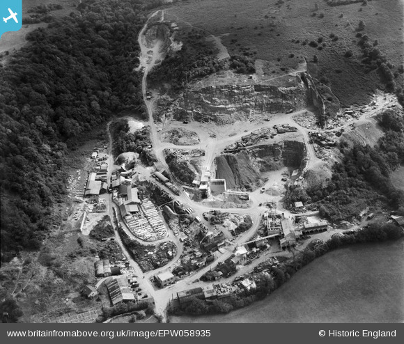
EPW058935 ENGLAND (1938). Backwell Quarry, Backwell Hill, 1938
© Copyright OpenStreetMap contributors and licensed by the OpenStreetMap Foundation. 2024. Cartography is licensed as CC BY-SA.
Nearby Images (21)
Details
| Title | [EPW058935] Backwell Quarry, Backwell Hill, 1938 |
| Reference | EPW058935 |
| Date | 17-August-1938 |
| Link | |
| Place name | BACKWELL HILL |
| Parish | BACKWELL |
| District | |
| Country | ENGLAND |
| Easting / Northing | 349141, 167924 |
| Longitude / Latitude | -2.7313004104285, 51.407563444442 |
| National Grid Reference | ST491679 |
Pins
 oldjets |
Sunday 24th of October 2021 09:59:35 PM |


![[EPW058935] Backwell Quarry, Backwell Hill, 1938](http://britainfromabove.org.uk/sites/all/libraries/aerofilms-images/public/100x100/EPW/058/EPW058935.jpg)
![[EPW058932] Backwell Quarry, Backwell Hill, from the north-east, 1938](http://britainfromabove.org.uk/sites/all/libraries/aerofilms-images/public/100x100/EPW/058/EPW058932.jpg)
![[EPW058930] Backwell Quarry, Backwell Hill, 1938](http://britainfromabove.org.uk/sites/all/libraries/aerofilms-images/public/100x100/EPW/058/EPW058930.jpg)
![[EPW058929] Backwell Quarry, Backwell Hill, 1938](http://britainfromabove.org.uk/sites/all/libraries/aerofilms-images/public/100x100/EPW/058/EPW058929.jpg)
![[EPW058931] Backwell Quarry, Backwell Hill, 1938](http://britainfromabove.org.uk/sites/all/libraries/aerofilms-images/public/100x100/EPW/058/EPW058931.jpg)
![[EAW023895] Coles Stone Quarry, Backwell, from the north, 1949. This image has been produced from a print marked by Aerofilms Ltd for photo editing.](http://britainfromabove.org.uk/sites/all/libraries/aerofilms-images/public/100x100/EAW/023/EAW023895.jpg)
![[EPW058933] Backwell Quarry, Backwell Hill, 1938](http://britainfromabove.org.uk/sites/all/libraries/aerofilms-images/public/100x100/EPW/058/EPW058933.jpg)
![[EPW058934] Backwell Quarry, Backwell Hill, 1938](http://britainfromabove.org.uk/sites/all/libraries/aerofilms-images/public/100x100/EPW/058/EPW058934.jpg)
![[EAW023894] Coles Stone Quarry, Backwell, 1949. This image has been produced from a print marked by Aerofilms Ltd for photo editing.](http://britainfromabove.org.uk/sites/all/libraries/aerofilms-images/public/100x100/EAW/023/EAW023894.jpg)
![[EAW023890] Coles Stone Quarry, Backwell, 1949. This image has been produced from a print.](http://britainfromabove.org.uk/sites/all/libraries/aerofilms-images/public/100x100/EAW/023/EAW023890.jpg)
![[EAW023898] Part of the Coles Stone Quarry, Backwell, 1949. This image has been produced from a print marked by Aerofilms Ltd for photo editing.](http://britainfromabove.org.uk/sites/all/libraries/aerofilms-images/public/100x100/EAW/023/EAW023898.jpg)
![[EAW023896] Coles Stone Quarry, Backwell, from the north, 1949. This image has been produced from a print marked by Aerofilms Ltd for photo editing.](http://britainfromabove.org.uk/sites/all/libraries/aerofilms-images/public/100x100/EAW/023/EAW023896.jpg)
![[EAW023893] Coles Stone Quarry, Backwell, from the north-west, 1949. This image has been produced from a print marked by Aerofilms Ltd for photo editing.](http://britainfromabove.org.uk/sites/all/libraries/aerofilms-images/public/100x100/EAW/023/EAW023893.jpg)
![[EAW015777] Coles Stone Quarry, Backwell, 1948. This image has been produced from a print marked by Aerofilms Ltd for photo editing.](http://britainfromabove.org.uk/sites/all/libraries/aerofilms-images/public/100x100/EAW/015/EAW015777.jpg)
![[EAW023897] Part of the Coles Stone Quarry, Backwell, 1949. This image has been produced from a print.](http://britainfromabove.org.uk/sites/all/libraries/aerofilms-images/public/100x100/EAW/023/EAW023897.jpg)
![[EAW015775] Coles Stone Quarry and Church Town, Backwell, 1948. This image has been produced from a print.](http://britainfromabove.org.uk/sites/all/libraries/aerofilms-images/public/100x100/EAW/015/EAW015775.jpg)
![[EAW038216] Backwell Quarry, Backwell Hill, 1951. This image has been produced from a print.](http://britainfromabove.org.uk/sites/all/libraries/aerofilms-images/public/100x100/EAW/038/EAW038216.jpg)
![[EAW015771] Coles Stone Quarry and Cheston Combe, Backwell, 1948. This image has been produced from a print marked by Aerofilms Ltd for photo editing.](http://britainfromabove.org.uk/sites/all/libraries/aerofilms-images/public/100x100/EAW/015/EAW015771.jpg)
![[EAW015778] Coles Stone Quarry and Cheston Combe, Backwell, from the west, 1948. This image has been produced from a print marked by Aerofilms Ltd for photo editing.](http://britainfromabove.org.uk/sites/all/libraries/aerofilms-images/public/100x100/EAW/015/EAW015778.jpg)
![[EAW015774] Coles Stone Quarry and the village, Backwell, 1948. This image has been produced from a print marked by Aerofilms Ltd for photo editing.](http://britainfromabove.org.uk/sites/all/libraries/aerofilms-images/public/100x100/EAW/015/EAW015774.jpg)
![[EAW015772] Coles Stone Quarry and Cheston Combe, Backwell, 1948. This image has been produced from a print marked by Aerofilms Ltd for photo editing.](http://britainfromabove.org.uk/sites/all/libraries/aerofilms-images/public/100x100/EAW/015/EAW015772.jpg)