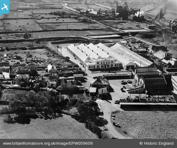
EPW059609 ENGLAND (1938). The Climax Rock Drill and Engineering Works and environs, Carn Brea, 1938
© Copyright OpenStreetMap contributors and licensed by the OpenStreetMap Foundation. 2025. Cartography is licensed as CC BY-SA.
Nearby Images (28)
Details
| Title | [EPW059609] The Climax Rock Drill and Engineering Works and environs, Carn Brea, 1938 |
| Reference | EPW059609 |
| Date | September-1938 |
| Link | |
| Place name | CARN BREA |
| Parish | CARN BREA |
| District | |
| Country | ENGLAND |
| Easting / Northing | 166441, 41315 |
| Longitude / Latitude | -5.2748877322215, 50.225019098008 |
| National Grid Reference | SW664413 |
Pins
Be the first to add a comment to this image!


![[EPW059609] The Climax Rock Drill and Engineering Works and environs, Carn Brea, 1938](http://britainfromabove.org.uk/sites/all/libraries/aerofilms-images/public/100x100/EPW/059/EPW059609.jpg)
![[EPW059611] The Climax Rock Drill and Engineering Works and environs, Carn Brea, 1938](http://britainfromabove.org.uk/sites/all/libraries/aerofilms-images/public/100x100/EPW/059/EPW059611.jpg)
![[EAW033746] The Climax Rock Drill and Engineering Works, Carn Brea, 1950. This image was marked by Aerofilms Ltd for photo editing.](http://britainfromabove.org.uk/sites/all/libraries/aerofilms-images/public/100x100/EAW/033/EAW033746.jpg)
![[EAW033742] The Climax Rock Drill and Engineering Works, Carn Brea, 1950. This image was marked by Aerofilms Ltd for photo editing.](http://britainfromabove.org.uk/sites/all/libraries/aerofilms-images/public/100x100/EAW/033/EAW033742.jpg)
![[EAW033744] The Climax Rock Drill and Engineering Works, Carn Brea, 1950](http://britainfromabove.org.uk/sites/all/libraries/aerofilms-images/public/100x100/EAW/033/EAW033744.jpg)
![[EAW033751] The Climax Rock Drill and Engineering Works, Carn Brea, 1950. This image was marked by Aerofilms Ltd for photo editing.](http://britainfromabove.org.uk/sites/all/libraries/aerofilms-images/public/100x100/EAW/033/EAW033751.jpg)
![[EPW059618] The Climax Rock Drill and Engineering Works and environs, Carn Brea, 1938](http://britainfromabove.org.uk/sites/all/libraries/aerofilms-images/public/100x100/EPW/059/EPW059618.jpg)
![[EAW033745] The Climax Rock Drill and Engineering Works, Carn Brea, 1950. This image was marked by Aerofilms Ltd for photo editing.](http://britainfromabove.org.uk/sites/all/libraries/aerofilms-images/public/100x100/EAW/033/EAW033745.jpg)
![[EAW033743] The Climax Rock Drill and Engineering Works, Carn Brea, 1950](http://britainfromabove.org.uk/sites/all/libraries/aerofilms-images/public/100x100/EAW/033/EAW033743.jpg)
![[EAW033750] The Climax Rock Drill and Engineering Works, Carn Brea, 1950. This image was marked by Aerofilms Ltd for photo editing.](http://britainfromabove.org.uk/sites/all/libraries/aerofilms-images/public/100x100/EAW/033/EAW033750.jpg)
![[EAW033752] The Climax Rock Drill and Engineering Works, Carn Brea, 1950. This image was marked by Aerofilms Ltd for photo editing.](http://britainfromabove.org.uk/sites/all/libraries/aerofilms-images/public/100x100/EAW/033/EAW033752.jpg)
![[EPW059616] The Climax Rock Drill and Engineering Works and environs, Carn Brea, 1938](http://britainfromabove.org.uk/sites/all/libraries/aerofilms-images/public/100x100/EPW/059/EPW059616.jpg)
![[EPW059612] The Climax Rock Drill and Engineering Works and environs, Carn Brea, 1938](http://britainfromabove.org.uk/sites/all/libraries/aerofilms-images/public/100x100/EPW/059/EPW059612.jpg)
![[EPW059613] The Climax Rock Drill and Engineering Works and environs, Carn Brea, 1938. This image has been produced from a copy-negative.](http://britainfromabove.org.uk/sites/all/libraries/aerofilms-images/public/100x100/EPW/059/EPW059613.jpg)
![[EPW059614] The Climax Rock Drill and Engineering Works and environs, Carn Brea, 1938](http://britainfromabove.org.uk/sites/all/libraries/aerofilms-images/public/100x100/EPW/059/EPW059614.jpg)
![[EAW033747] The Climax Rock Drill and Engineering Works, Carn Brea, 1950. This image was marked by Aerofilms Ltd for photo editing.](http://britainfromabove.org.uk/sites/all/libraries/aerofilms-images/public/100x100/EAW/033/EAW033747.jpg)
![[EAW033749] The Climax Rock Drill and Engineering Works, Carn Brea, 1950. This image was marked by Aerofilms Ltd for photo editing.](http://britainfromabove.org.uk/sites/all/libraries/aerofilms-images/public/100x100/EAW/033/EAW033749.jpg)
![[EPW059610] The Climax Rock Drill and Engineering Works and environs, Carn Brea, 1938](http://britainfromabove.org.uk/sites/all/libraries/aerofilms-images/public/100x100/EPW/059/EPW059610.jpg)
![[EAW033748] The Climax Rock Drill and Engineering Works, Carn Brea, 1950. This image was marked by Aerofilms Ltd for photo editing.](http://britainfromabove.org.uk/sites/all/libraries/aerofilms-images/public/100x100/EAW/033/EAW033748.jpg)
![[EPW009925] Rock Drill Works and the Tramway Depot, Redruth, 1924](http://britainfromabove.org.uk/sites/all/libraries/aerofilms-images/public/100x100/EPW/009/EPW009925.jpg)
![[EPW009918] Rock Drill Works, Redruth, 1924](http://britainfromabove.org.uk/sites/all/libraries/aerofilms-images/public/100x100/EPW/009/EPW009918.jpg)
![[EPW059615] The Climax Rock Drill and Engineering Works and environs, Carn Brea, 1938](http://britainfromabove.org.uk/sites/all/libraries/aerofilms-images/public/100x100/EPW/059/EPW059615.jpg)
![[EPW009919] Rock Drill Works and the Tramway Depot, Redruth, 1924](http://britainfromabove.org.uk/sites/all/libraries/aerofilms-images/public/100x100/EPW/009/EPW009919.jpg)
![[EPW009920] Rock Drill Works and the Tramway Depot, Redruth, 1924](http://britainfromabove.org.uk/sites/all/libraries/aerofilms-images/public/100x100/EPW/009/EPW009920.jpg)
![[EPW009924] Rock Drill Works and the Tramway Depot, Redruth, 1924](http://britainfromabove.org.uk/sites/all/libraries/aerofilms-images/public/100x100/EPW/009/EPW009924.jpg)
![[EPW009921] Rock Drill Works, Redruth, 1924](http://britainfromabove.org.uk/sites/all/libraries/aerofilms-images/public/100x100/EPW/009/EPW009921.jpg)
![[EPW009923] Rock Drill Works, Redruth, 1924](http://britainfromabove.org.uk/sites/all/libraries/aerofilms-images/public/100x100/EPW/009/EPW009923.jpg)
![[EPW009922] Rock Drill Works and the Tramway Depot, Redruth, 1924](http://britainfromabove.org.uk/sites/all/libraries/aerofilms-images/public/100x100/EPW/009/EPW009922.jpg)